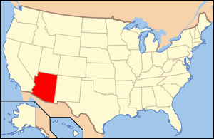
National Register of Historic Places listings in Prescott, Arizona

This is a list of the National Register of Historic Places listings in Prescott, Arizona. It is intended to be a complete list of the properties and districts on the National Register of Historic Places in Prescott, Arizona, United States. The locations of National Register properties and districts for which the latitude and longitude coordinates are included below, may be seen in an online map.[1]
There are 130 properties and districts listed on the National Register in Yavapai County, including 1 that is also a National Historic Landmark. 71 of these properties and districts are located in the city of Prescott, and are listed here, while the remaining 59 properties and districts are located elsewhere in the county, and are |listed separately under National Register of Historic Places listings in Yavapai County, Arizona.
- This National Park Service list is complete through NPS recent listings posted December 16, 2016.[2]
Current listings
| [3] | Name on the Register[4] | Image | Date listed[5] | Location | City or town | Description |
|---|---|---|---|---|---|---|
| 1 | Arizona Pioneers' Home | 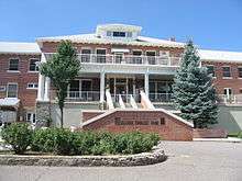 |
(#95001363) |
300 S. McCormick St. 34°32′15″N 112°28′25″W / 34.5375°N 112.473611°W |
Retirement home complex overlooking Prescott | |
| 2 | Blumberg House |  |
(#78003217) |
143 N. Mt. Vernon 34°32′36″N 112°27′47″W / 34.543425°N 112.463189°W |
||
| 3 | Brinkmeyer House |  |
(#78003218) |
605 W. Gurley 34°32′31″N 112°28′39″W / 34.541942°N 112.477543°W |
||
| 4 | Burmister/Timerhoff House | 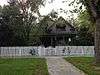 |
(#78003219) |
116 S. Mt. Vernon 34°32′28″N 112°27′49″W / 34.54118°N 112.463611°W |
||
| 5 | Clark House | 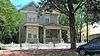 |
(#78003220) |
109 N. Pleasant 34°32′32″N 112°27′51″W / 34.542243°N 112.464197°W |
||
| 6 | Courthouse Plaza Historic District | 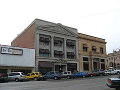 |
(#78003583) |
Roughly bounded by Gurley, Montezuma, Cortez, and Goodwin Sts. Coordinates missing |
||
| 7 | Curtis Cottage |  |
(#93000344) |
125 S. McCormick 34°32′33″N 112°28′22″W / 34.5425°N 112.472778°W |
||
| 8 | Day House |  |
(#78003222) |
212 E. Gurley 34°32′32″N 112°28′00″W / 34.542125°N 112.466709°W |
||
| 9 | Detwiler House |  |
(#78003223) |
310 N. Alarcon Coordinates missing |
||
| 10 | Drake House |  |
(#78003224) |
137 N. Mt. Vernon 34°32′25″N 112°27′46″W / 34.540387°N 112.462772°W |
||
| 11 | Charles H. Dunning Log Cabin | 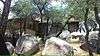 |
(#93000870) |
811 Boulder Dr. 34°31′40″N 112°28′59″W / 34.527778°N 112.483056°W |
||
| 12 | East Prescott Historic District |  |
(#89000165) |
Roughly bounded by Atchison, Topeka, and Santa Fe railroad tracks, N. Mt. Vernon St., Carleton St., and N. Alarcon St. 34°32′35″N 112°27′49″W / 34.543056°N 112.463611°W |
||
| 13 | Elks Building and Theater | 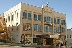 |
(#78003226) |
117 E. Gurley 34°32′30″N 112°28′04″W / 34.541694°N 112.467752°W |
||
| 14 | First Congregational Church and Parsonage | 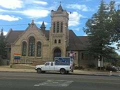 |
(#78003227) |
216-220 E. Gurley Coordinates missing |
||
| 15 | Fisher/Goldwater House | 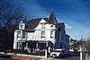 |
(#78003228) |
240 S. Cortez Coordinates missing |
||
| 16 | Fleury's Addition Historic District | Upload image | (#94001488) |
Roughly Western and Gurley from Willow to Grove, and Willow, Garden, and Grove from Western to Gurley 34°33′26″N 112°27′55″W / 34.557222°N 112.465278°W |
||
| 17 | Fort Whipple-Department of Veterans Affairs Medical Center Historic District |  |
(#99001274) |
500 State Route 89 N. 34°32′58″N 112°27′04″W / 34.549444°N 112.451111°W |
Fort Whipple, Arizona | |
| 18 | Fredericks House | Upload image | (#78003229) |
202 S. Pleasant Coordinates missing |
||
| 19 | Gage/Murphy House | 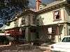 |
(#78003230) |
105 S. Alarcon Coordinates missing |
||
| 20 | James I. Gardner Store |  |
(#85000056) |
201 N. Cortez 34°32′43″N 112°28′16″W / 34.545278°N 112.471111°W |
||
| 21 | Henry Goldwater House | 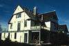 |
(#82002091) |
217 E. Union St. 34°32′27″N 112°27′55″W / 34.540833°N 112.465278°W |
||
| 22 | Groom Creek School | Upload image | (#92001568) |
Senator Highway southeast of Prescott in the Prescott National Forest 34°28′15″N 112°26′02″W / 34.470833°N 112.433889°W |
||
| 23 | Hassayampa Historic District | 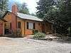 |
(#03000469) |
1089-1112 Old Hassayampa Ln. and 1106 Country Club Dr. 34°32′08″N 112°29′24″W / 34.535556°N 112.49°W |
||
| 24 | Hassayampa Hotel | 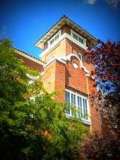 |
(#79000429) |
122 E. Gurley St 34°32′32″N 112°28′01″W / 34.542222°N 112.466944°W |
Spanish Colonial Revival design by Henry Trost, architect, 1927 | |
| 25 | Hawkins House | 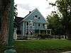 |
(#78003232) |
122 S. Mt. Vernon 34°32′28″N 112°27′47″W / 34.541025°N 112.463192°W |
||
| 26 | Hazeltine House |  |
(#78003233) |
202 S. Mt. Vernon 34°32′23″N 112°27′49″W / 34.539615°N 112.463596°W |
||
| 27 | Head House | 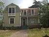 |
(#78003234) |
309 E. Gurley 34°32′31″N 112°27′55″W / 34.541969°N 112.465147°W |
||
| 28 | Hill House |  |
(#78003235) |
144 S. Park Coordinates missing |
||
| 29 | Sam Hill Hardware | 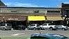 |
(#78003252) |
154 S. Montezuma Coordinates missing |
Three retail businesses; currently numbered as 156 S. Montezuma | |
| 30 | Samuel Hill Hardware Company Warehouse |  |
(#84000772) |
232 N. McCormick St. 34°32′44″N 112°28′16″W / 34.545556°N 112.471111°W |
||
| 31 | Hotel Vendome | 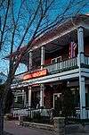 |
(#83003495) |
230 S. Cortez 34°32′20″N 112°28′06″W / 34.538889°N 112.468333°W |
Operating hotel | |
| 32 | Indian Peak Ruin (AR-03-09-06-116) | Upload image | (#88003185) |
Address Restricted |
Sinagua ruin | |
| 33 | Iron Turbine Windmill | 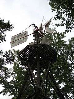 |
(#81000139) |
415 W. Gurley St. 34°32′30″N 112°28′27″W / 34.541667°N 112.474167°W |
Part of Sharlot Hall Museum | |
| 34 | Joslin and Whipple Historic District | Upload image | (#00001387) |
S. Mt. Vernon, Virginia, Washington, and Arizona Sts. 34°32′19″N 112°27′42″W / 34.538611°N 112.461667°W |
||
| 35 | Kenwill Apartments |  |
(#87002494) |
119-127 E. Goodwin St. 34°32′23″N 112°28′01″W / 34.539722°N 112.466944°W |
||
| 36 | Lawler-Hetherington Double House |  |
(#78003237) |
223 E. Union Coordinates missing |
||
| 37 | Lynx Creek Bridge | Upload image | (#88001641) |
5.9 mi (9.5 km) east of Prescott on the Old Black Canyon Highway 34°33′08″N 112°22′21″W / 34.552222°N 112.3725°W |
||
| 38 | Lynx Creek District | Upload image | (#78000571) |
East of Prescott 34°34′28″N 112°20′50″W / 34.574444°N 112.347222°W |
||
| 39 | Marks House |  |
(#78003239) |
203 E. Union Coordinates missing |
||
| 40 | Martin/Ling House |  |
(#78003240) |
125 N. Pleasant Coordinates missing |
||
| 41 | Mile High Park Historic District | Upload image | (#99001069) |
Roughly along Oregon Ave. and Josephine St. from Gail Gardner Way and Lindberg Dr. 34°32′49″N 112°29′36″W / 34.546944°N 112.493333°W |
||
| 42 | Morin House |  |
(#78003242) |
134 N. Mt. Vernon 34°32′26″N 112°27′47″W / 34.54057°N 112.463188°W |
||
| 43 | Former LDS Church |  |
(#83003496) |
126 N. Marina St. 34°32′35″N 112°28′01″W / 34.543056°N 112.466944°W |
Converted to commercial use in 1982. | |
| 44 | Morrison House |  |
(#78003243) |
300 S. Marina Coordinates missing |
||
| 45 | Mountain States Telephone and Telegraph Exchange Building (Prescott, Arizona) | Upload image | (#04000512) |
116 N. Marina St. 34°32′38″N 112°28′05″W / 34.543889°N 112.468056°W |
||
| 46 | Mulvenon Building |  |
(#93000287) |
230 W. Gurley St. 34°32′32″N 112°28′17″W / 34.542222°N 112.471389°W |
||
| 47 | North Prescott Townsite Historic District | Upload image | (#08001188) |
Between Gurley, Sheldon, Alarcon and Summit Sts. 34°32′38″N 112°28′11″W / 34.543808°N 112.46965°W |
||
| 48 | Old Governor's Mansion |  |
(#71000121) |
415 W. Gurley[6] 34°32′29″N 112°28′23″W / 34.5414°N 112.4731°W |
Now part of the Sharlot Hall Museum [6] | |
| 49 | Otis House |  |
(#78003245) |
113 N. Pleasant Coordinates missing |
||
| 50 | Palace Station District | Upload image | (#76000382) |
23 mi (37 km) south of Prescott in the Prescott National Forest 34°22′35″N 112°24′32″W / 34.376389°N 112.408889°W |
Stagecoach station, built 1874 | |
| 51 | Peter House |  |
(#78003247) |
211 E. Union Coordinates missing |
||
| 52 | Pine Crest Historic District | Upload image | (#89001074) |
Roughly bounded by San Carlos St., Coronado Ave., and Yavapai, Apache, and Mohave Drs. 34°32′19″N 112°29′03″W / 34.538611°N 112.484167°W |
||
| 53 | Prescott Armory Historic District |  |
(#94000829) |
Roughly bounded by E. Gurley, E. Willis, N. Arizona, E. Sheldon, and N. Rush Sts. 34°33′26″N 112°26′26″W / 34.557222°N 112.440556°W |
||
| 54 | Prescott Public Library | 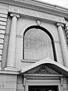 |
(#75000365) |
125 E. Gurley St. 34°32′28″N 112°28′02″W / 34.541111°N 112.467222°W |
Old Carnegie library, now an office building | |
| 55 | Roberts House |  |
(#78003249) |
136 N. Pleasant Coordinates missing |
||
| 56 | A. W. Robinson Building |  |
(#78003250) |
115 N. Grove Coordinates missing |
||
| 57 | Sacred Heart Catholic Church and Rectory | 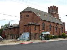 |
(#78003251) |
208 N. Marina Coordinates missing |
Now used as the Prescott Fine Arts Association gallery | |
| 58 | Santa Fe, Prescott and Phoenix Railroad Depot | 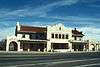 |
(#82004978) |
Cortez St. 34°32′43″N 112°28′05″W / 34.545278°N 112.468056°W |
||
| 59 | Sewall House |  |
(#78003253) |
220 N. Mt. Vernon Coordinates missing |
||
| 60 | Shekels House | 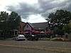 |
(#78003254) |
226 S. Cortez 34°32′21″N 112°27′49″W / 34.539161°N 112.463592°W |
||
| 61 | Sloan House | 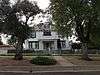 |
(#78003255) |
128 N. Mt. Vernon 34°32′27″N 112°27′49″W / 34.540724°N 112.463606°W |
||
| 62 | South Prescott Townsite | Upload image | (#97000859) |
Roughly bounded by Alarcon, Montezuma, Union, and Leroux Sts. 34°32′11″N 112°28′04″W / 34.536389°N 112.467778°W |
||
| 63 | Toltec Lodge | 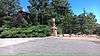 |
(#00000812) |
228 High St. 34°32′23″N 112°28′47″W / 34.539722°N 112.479722°W |
||
| 64 | US Post Office and Courthouse-Prescott Main |  |
(#85003108) |
101 W. Goodwin Ave. 34°32′24″N 112°28′09″W / 34.54°N 112.469167°W |
||
| 65 | Walker Charcoal Kiln | 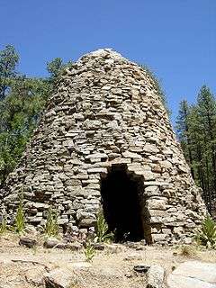 |
(#76000383) |
Southeast of Prescott in the Prescott National Forest 34°27′30″N 112°22′31″W / 34.458333°N 112.375278°W |
||
| 66 | Walnut Creek Ranger Station | Upload image | (#93000524) |
Northwest of Prescott in the Prescott National Forest 34°55′28″N 112°50′24″W / 34.924444°N 112.84°W |
||
| 67 | Wells House | 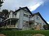 |
(#78003257) |
303 S. Cortez Coordinates missing |
||
| 68 | West Prescott Historic District | Upload image | (#89001075) |
Roughly bounded by Gurley Dr., Park Ave., Country Club Dr., Vista Dr., and Coronado Ave.; also 617-621 Glenwood Ave. and 330, 334, 340, 344, and 348 Moreland Circle 34°32′15″N 112°28′41″W / 34.5375°N 112.478056°W |
Second set of addresses represents a boundary increase | |
| 69 | Whipple Heights Historic District | Upload image | (#00001388) |
E. Gurley, N. Virginia, Washington, and E. Moeller Sts. 34°32′36″N 112°27′40″W / 34.543333°N 112.461111°W |
||
| 70 | Wilder House | 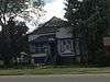 |
(#78003259) |
346 S. Montezuma 34°32′11″N 112°28′14″W / 34.536332°N 112.470619°W |
||
| 71 | Yavapai County Courthouse |  |
(#77000241) |
Courthouse Plaza 34°32′27″N 112°28′06″W / 34.540833°N 112.468333°W |
1918 Greek Revival style building |
Former listing
| [3] | Name on the Register | Image | Date listed | Date removed | Location | City or town | Summary |
|---|---|---|---|---|---|---|---|
| 1 | Curtis Hall | Upload image | (#78003221) | 133 S. McCormick |
|||
| 2 | Goldwater Mercantile | Upload image | (#78003584) | 127 S. Cortez |
|||
| 3 | Mulvenon House | Upload image | (#78003244) | 233 S. Cortez |
See also
| Wikimedia Commons has media related to National Register of Historic Places in Prescott, Arizona. |
- List of National Historic Landmarks in Arizona
- National Register of Historic Places listings in Arizona
References
- ↑ The latitude and longitude information provided in this table was derived originally from the National Register Information System, which has been found to be fairly accurate for about 99% of listings. For about 1% of NRIS original coordinates, experience has shown that one or both coordinates are typos or otherwise extremely far off; some corrections may have been made. A more subtle problem causes many locations to be off by up to 150 yards, depending on location in the country: most NRIS coordinates were derived from tracing out latitude and longitudes off of USGS topographical quadrant maps created under the North American Datum of 1927, which differs from the current, highly accurate WGS84 GPS system used by most on-line maps. Chicago is about right, but NRIS longitudes in Washington are higher by about 4.5 seconds, and are lower by about 2.0 seconds in Maine. Latitudes differ by about 1.0 second in Florida. Some locations in this table may have been corrected to current GPS standards.
- ↑ "National Register of Historic Places: Weekly List Actions". National Park Service, United States Department of the Interior. Retrieved on December 16, 2016.
- 1 2 Numbers represent an ordering by significant words. Various colorings, defined here, differentiate National Historic Landmarks and historic districts from other NRHP buildings, structures, sites or objects.
- ↑ National Park Service (2008-04-24). "National Register Information System". National Register of Historic Places. National Park Service.
- ↑ The eight-digit number below each date is the number assigned to each location in the National Register Information System database, which can be viewed by clicking the number.
- 1 2 Address derived from this National Park Service website; the NRIS lists it at "400 block of W. Gurley".
 |  | ||
