National Register of Historic Places listings in La Paz County, Arizona

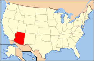
Location of La Paz County in Arizona
This is a list of the National Register of Historic Places listings in La Paz County, Arizona.
This is intended to be a complete list of the properties and districts on the National Register of Historic Places in La Paz County, Arizona, United States. The locations of National Register properties and districts for which the latitude and longitude coordinates are included below, may be seen in a map.[1]
There are 10 properties and districts listed on the National Register in the county.
- This National Park Service list is complete through NPS recent listings posted December 16, 2016.[2]
Current listings
| [3] | Name on the Register | Image | Date listed[4] | Location | City or town | Description |
|---|---|---|---|---|---|---|
| 1 | Eagletail Petroglyph Site | Upload image | (#88001570) |
Address Restricted |
Hyder | |
| 2 | Harquahala Mountain Smithsonian Solar Observatory Historic District | Upload image | (#97000346) |
Harquahala Mountain (Wilderness), southwest of Gladden Coordinates missing |
Gladden | |
| 3 | Harquahala Peak Observatory | Upload image | (#75000370) |
East of Wenden off U.S. Route 60 33°48′48″N 113°20′44″W / 33.813333°N 113.345556°W |
Wenden | |
| 4 | Hi Jolly Monument |  |
(#11000054) |
North end of Cemetery Rd. 33°39′52″N 114°14′11″W / 33.664444°N 114.236389°W |
Quartzsite | Pyramidal Monuments in Arizona MPS |
| 5 | Rhoda Nohlechek House | Upload image | (#96000529) |
Northwestern corner of the junction of 2nd St. and Date Ave. 33°49′24″N 113°32′27″W / 33.823333°N 113.540833°W |
Wenden | |
| 6 | Old La Paz | Upload image | (#70000117) |
Address Restricted |
Ehrenberg | |
| 7 | Old Presbyterian Church | Upload image | (#71000122) |
Southwest of Parker on 2nd Ave. 34°06′45″N 114°18′48″W / 34.1125°N 114.313333°W |
Parker | |
| 8 | Parker Jail | Upload image | (#75000369) |
Northern side of Agency Rd. in Pop Harvey Park 34°08′55″N 114°17′39″W / 34.148611°N 114.294167°W |
Parker | |
| 9 | Poston Elementary School, Unit 1, Colorado River Relocation Center | 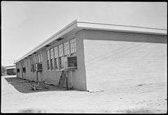 |
(#12001010) |
Poston Rd. 0.4 miles (0.64 km) west of Mohave Rd. 33°59′40″N 114°24′24″W / 33.994444°N 114.406667°W |
Parker | Elementary school at Poston War Relocation Center[5] |
| 10 | Ripley Intaglios | Upload image | (#75000368) |
Address Restricted |
Ehrenberg |
See also
| Wikimedia Commons has media related to National Register of Historic Places in La Paz County, Arizona. |
- List of National Historic Landmarks in Arizona
- National Register of Historic Places listings in Arizona
References
- ↑ The latitude and longitude information provided in this table was derived originally from the National Register Information System, which has been found to be fairly accurate for about 99% of listings. For about 1% of NRIS original coordinates, experience has shown that one or both coordinates are typos or otherwise extremely far off; some corrections may have been made. A more subtle problem causes many locations to be off by up to 150 yards, depending on location in the country: most NRIS coordinates were derived from tracing out latitude and longitudes off of USGS topographical quadrant maps created under the North American Datum of 1927, which differs from the current, highly accurate WGS84 GPS system used by most on-line maps. Chicago is about right, but NRIS longitudes in Washington are higher by about 4.5 seconds, and are lower by about 2.0 seconds in Maine. Latitudes differ by about 1.0 second in Florida. Some locations in this table may have been corrected to current GPS standards.
- ↑ "National Register of Historic Places: Weekly List Actions". National Park Service, United States Department of the Interior. Retrieved on December 16, 2016.
- ↑ Numbers represent an ordering by significant words. Various colorings, defined here, differentiate National Historic Landmarks and historic districts from other NRHP buildings, structures, sites or objects.
- ↑ The eight-digit number below each date is the number assigned to each location in the National Register Information System database, which can be viewed by clicking the number.
- ↑ Poston Relocation Center, National Park Service, 2000-09-01. Accessed 2014-01-02.
| Topics | |
|---|---|
| Lists by states |
|
| Lists by insular areas | |
| Lists by associated states | |
| Other areas | |
| |
 |  | ||
Municipalities and communities of La Paz County, Arizona, United States | ||
|---|---|---|
| Towns | | |
| CDPs | ||
| Unincorporated communities | ||
| Indian reservations | ||
| Ghost towns | ||
This article is issued from Wikipedia - version of the 8/2/2016. The text is available under the Creative Commons Attribution/Share Alike but additional terms may apply for the media files.