National Register of Historic Places listings in Klickitat County, Washington

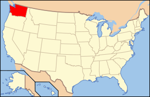
Location of Klickitat County in Washington
This list presents the full set of buildings, structures, objects, sites, or districts designated on the National Register of Historic Places in Klickitat County, Washington, and offers brief descriptive information about each of them. The National Register recognizes places of national, state, or local historic significance across the United States.[1] Out of over 90,000 National Register sites nationwide,[2] Washington is home to approximately 1,500,[3] and 11 of those are found in Klickitat County.
- This National Park Service list is complete through NPS recent listings posted December 2, 2016.[4]
Current listings
| [5] | Name on the Register | Image | Date listed[6] | Location | City or town | Description |
|---|---|---|---|---|---|---|
| 1 | Appleton Log Hall | 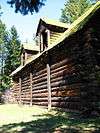 |
(#92001294) |
835 Appleton Rd. 45°48′36″N 121°16′30″W / 45.81°N 121.275°W |
Appleton | |
| 2 | First Day Advent Christian Church | 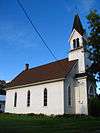 |
(#91001439) |
Jct. of Maryhill Hwy. and Stonehenge Ave. 45°41′14″N 120°48′47″W / 45.687222°N 120.813056°W |
Maryhill | |
| 3 | Goldendale Free Public Library |  |
(#82004259) |
131 W. Burgen 45°49′15″N 120°49′22″W / 45.820833°N 120.822778°W |
Goldendale | Carnegie Libraries of Washington TR |
| 4 | Klickitat County Courthouse | |
(#14000613) |
205 S. Columbus Ave. 45°49′17″N 120°49′22″W / 45.8213°N 120.8227°W |
Goldendale | |
| 5 | Maryhill |  |
(#74001966) |
SW of Goldendale on U.S. 197 45°40′40″N 120°51′48″W / 45.677778°N 120.863333°W |
Goldendale | |
| 6 | Charles Newell House |  |
(#77001344) |
114 Sentinel St. 45°49′02″N 120°49′22″W / 45.817222°N 120.822778°W |
Goldendale | |
| 7 | Rattlesnake Creek Site | 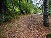 |
(#78002762) |
Address restricted[7] |
Husum | |
| 8 | Rowland Basin Site | Upload image | (#96000724) |
Address restricted[7] |
Lyle | |
| 9 | Trout Lake Tourist Club | 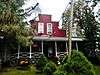 |
(#05001063) |
15 Guler Rd. 46°00′15″N 121°32′22″W / 46.004167°N 121.539444°W |
Trout Lake | |
| 10 | Whitcomb Cabin | .jpg) |
(#75001860) |
100 Wildlife Refuge Rd., 6 mi (9.7 km). W of Glenwood 45°57′48″N 121°20′34″W / 45.963333°N 121.342778°W |
Glenwood | |
| 11 | Wishram Indian Village Site |  |
(#72001278) |
Address restricted[7] |
The Dalles, Oregon, vicinity |
See also
- National Register of Historic Places listings in Washington state
- Listings in neighboring counties: Benton, Gilliam, Hood River, Morrow, Sherman, Skamania, Wasco, Yakima
- Historic preservation
- History of Washington (state)
- Index of Washington-related articles
References
- ↑ Andrus, Patrick W.; Shrimpton, Rebecca H.; et al. (2002), How to Apply the National Register Criteria for Evaluation, National Register Bulletin (15), National Park Service, U.S. Department of the Interior, retrieved June 20, 2014.
- ↑ National Park Service, National Register of Historic Places Program: Research, retrieved January 28, 2015.
- ↑ Department of Archaeology and Historic Preservation, Washington Information System for Architectural and Archaeological Records Data (WISAARD), retrieved February 14, 2015.
- ↑ "National Register of Historic Places: Weekly List Actions". National Park Service, United States Department of the Interior. Retrieved on December 2, 2016.
- ↑ Numbers represent an ordering by significant words. Various colorings, defined here, differentiate National Historic Landmarks and historic districts from other NRHP buildings, structures, sites or objects.
- ↑ The eight-digit number below each date is the number assigned to each location in the National Register Information System database, which can be viewed by clicking the number.
- 1 2 3 Federal and state laws and practices restrict general public access to information regarding the specific location of sensitive archeological sites in many instances. The main reasons for such restrictions include the potential for looting, vandalism, or trampling. See: Knoerl, John; Miller, Diane; Shrimpton, Rebecca H. (1990), Guidelines for Restricting Information about Historic and Prehistoric Resources, National Register Bulletin (29), National Park Service, U.S. Department of the Interior, OCLC 20706997.
External links
- Washington Department of Archaeology and Historic Preservation, Historic Register program
- National Park Service, National Register of Historic Places site
 Media related to National Register of Historic Places in Klickitat County, Washington at Wikimedia Commons

| Topics | |
|---|---|
| Lists by states |
|
| Lists by insular areas | |
| Lists by associated states | |
| Other areas | |
| |
Municipalities and communities of Klickitat County, Washington, United States | ||
|---|---|---|
| Cities | | |
| CDPs | ||
| Unincorporated communities | ||
| Ghost towns | ||
This article is issued from Wikipedia - version of the 1/18/2016. The text is available under the Creative Commons Attribution/Share Alike but additional terms may apply for the media files.