Naguanagua Municipality
| Naguanagua | |||
|---|---|---|---|
| Municipality | |||
| Municipio Naguanagua | |||
 | |||
| |||
 Naguanagua (City) in Carabobo State | |||
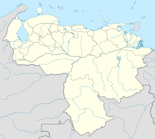 Naguanagua Location in Venezuela | |||
| Coordinates: 10°15′14.5″N 68°0′39.08″W / 10.254028°N 68.0108556°WCoordinates: 10°15′14.5″N 68°0′39.08″W / 10.254028°N 68.0108556°W | |||
| Country |
| ||
| State | Carabobo | ||
| Shiretown | Naguanagua | ||
| Government | |||
| • Mayor | Alejandro Feo la Cruz (PV) | ||
| Area | |||
| • Total | 188 km2 (73 sq mi) | ||
| Elevation | 497 m (1,631 ft) | ||
| Population (2011) | |||
| • Total | 157,437 | ||
| • Density | 840/km2 (2,200/sq mi) | ||
| Time zone | VST (UTC-4:30) | ||
| Area code(s) | 0241 | ||
| Website | Official website | ||
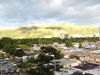
The Naguanagua (Spanish pronunciation: [naɣwaˈnaɣwa]) municipality is one of the 14 municipalities (municipios) that makes up the Venezuelan state of Carabobo and, according to the 2011 census by the National Institute of Statistics of Venezuela, the municipality has a population of 157,437. [1] The town of Naguanagua is the shire town of the Naguanagua Municipality.[2] It forms part of the greater Valencia Metropolitan Area in Venezuela. It is in the valley of the Cabriales River at the base of Cerro El Café and the El Trigal Mountain. Valencia and Naguanagua form a continuous urban area. The highway that runs from the centre of Valencia towards Puerto Cabello passes through this community; Bolivar Avenue in Valencia becomes University Avenue in Naguanagua on the northern side of a traffic roundabout, or redoma.
Demographics
The Naguanagua County, according to a 2007 population estimate by the National Institute of Statistics of Venezuela, has a population of 143,315 (up from 134,728 in 2000). This amounts to 6.4% of the state's population.[3] The municipality's population density is 762.31 inhabitants per square kilometre (1,974.4/sq mi).[4]
Government
The mayor of the Naguanagua County is Alejandro Feo la Cruz, elected on November 23, 2008 with 45% of the vote.[5] He replaced Julio Castillo shortly after the elections. The municipality is divided into one parish (Naguanagua).[2]
History
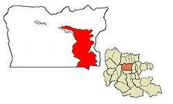
Naguanagua was originally founded as a parish district between Valencia and Puerto Cabello. The name of the district/municipio (similar to a county) is Naguanagua, and the main city in the district is Naguanagua. The map at top right shows the municipio in red and the other municipios of Carabobo in gray. Naguanagua was founded as a curacy on 14 May 1782 by the Bishop of Caracas Don Mariano Martí. The name Naguanagua means "Abundance of Waters".
Tourism and places of interest

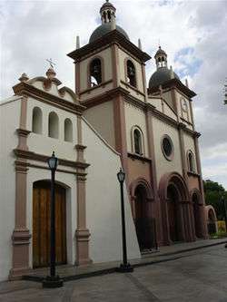
Downtown Naguanagua features the Parochial Church of Naguanagua, the Parochial House and Bolívar Square. Near the Carabobo Hospital is the Spaniards Road (Camino de Los Españoles), Colonial Way at the San Esteban National Park (Parque Nacional San Esteban), where one can to go down to San Esteban town near to Puerto Cabello. Also, you can visit La Entrada, a village near Naguanagua where there is the Atanasio Giradot Monument. Between the Sport Square are the "Don Bosco Field" (Campo Don Bosco) in the downtown, the "Simón Bolívar Bicentennial Sport Complex" in La Granja, the "Patinodrome of Capremco" and the "University City Sport Complex" in the Campus Bárbula. Naguanagua has the largest shopping centres Carabobo State including Sambil Centre in Ciudad Jardín Mañongo, La Granja Shopping Centre, Cristal Naguanagua Centre in Las Quintas III Stage and Vía Veneto Shopping Center in Ciudad Jardín Mañongo. Others places include the offices of El Carabobeño newspaper on University Avenue, Los Guayabitos Park, the Botanical Garden of Naguanagua (Salvador Feo La Cruz Avenue), Paseo La Granja Park (Venezuela Avenue), Liberty Park or the Peace Park (Liberty Corner, 10th Street Avenue of Las Quintas, La Granja), Park of Attractions "Dunas" near the first World Trade Centre of Venezuela, "Hesperia Río Convention Center" (Mañongo Road, Mañongo), and the Park of Attractions "Ditto Park" (Tazajal).
Universities
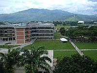
Naguanagua is the home of the main student campus of the University of Carabobo (Spanish:Universidad de Carabobo (UC). The administrative offices are in Valencia proper. The campus is quite large and operates as a separate community with its own security, transportation, and legislative body. Also, there are other universities such as University College of Administration and Trade (Colegio Universitario de Administración y Mercadeo CUAM) near Bárbula Bridge, the National "Open" University (Universidad Nacional Abierta UNA) in El Retobo, the National Polytechnic Research University of the Armed Forces (Universidad Nacional Experimental Politécnica de las Fuerzas Armadas UNEFA) in Las Quintas I stage, and the Bicentennial University of Aragua (Universidad Bicentenaria de Aragua UBA) in La Campiña.
Roads
Road transportation inside the city is provided by the Centre Regional Highway (Autopista Regional del Centro (ARC) and major arterials such as University Avenue, Salvador Feo La Cruz (North - South) Avenue(old Cemetery Avenue), Valencia Avenue, Naguanagua's Bolívar Avenue, Salvador Feo La Cruz (Easth-West) Avenue, 190 Avenue, Salvador Allende Avenue (University City Campus Bárbula Universidad de Carabobo).
Neighborhoods
190 | Agua Linda | Arturo Ramírez | Av. 181 Valencia | Barrio Unión | Barrio Oeste | Bella Vista | Brisas de Carabobo | Brisas del Café | Campus Bárbula - Ciudad Universitaria - | Capremco | Carialinda | Chaguaramal | Ciudad Jardín Mañongo | Centro Histórico de Naguanagua | Colinas de Girardot I | Colinas de Girardot II | Colón | Democracia | El Cafetal | El Naranjal I | El Naranjal II | El Pinar | El Piñal | El Retobo | El Rincón | Guayabal | Guaparo Naguanagüense | Güere | Gonzalez Plaza | La Begoña | La Campiña I | La Campiña II | La Campiña III | La Cidra | La Florida | La Granja I | La Granja II | La Llovizna | La Luz | La Querencia | La Sabana | La Coromoto | Las Palmeras | Las Quintas I | Las Quintas II | Las Quintas III (Quintas del Norte) | Lorenzo Fernández | Los Candiles | Los Caracaros | Los Guayabitos | Malagón | Mañongo | Monte Sión | Negra Matea | Nueva Esparta | Palma Real | Parque Naguanagua | Puente Bárbula | Rotafé | Santa Ana | Santa Eduviges (Vivienda Rural Bárbula) | Santa Marta | Tarapio | Tazajal | Terrazas de Naguanagua | Terrazas de Paramacay | Valle Verde
References
- ↑ http://www.geohive.com/cntry/venezuela_ext.aspx
- 1 2 http://www.ine.gob.ve/secciones/division/Carabobo.zip
- ↑ http://www.ine.gob.ve/sintesisestadistica/estados/carabobo/cuadros/Poblacion5.xls
- ↑ http://www.ine.gob.ve/sintesisestadistica/estados/carabobo/cuadros/Poblacion4.xls
- ↑ http://www.cne.gob.ve/divulgacion_regionales_2008/index.php?e=07&m=00&p=00&c=00&t=00&ca=00&v=02
External links
- naguanagua-carabobo.gob.ve (Spanish)
- Municipal Government of Naguanagua site (Spanish)
- Naguanagua Forest (Spanish)