Murray-Sunset National Park
| Murray-Sunset National Park Victoria | |
|---|---|
|
IUCN category II (national park) | |
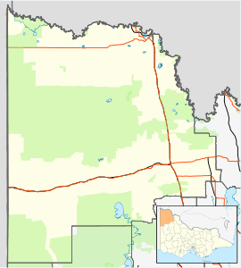
 Pink Lakes (salt lakes) in the national park. | |
 Murray-Sunset National Park | |
| Nearest town or city | Mildura |
| Coordinates | 34°46′06″S 141°51′15″E / 34.76833°S 141.85417°ECoordinates: 34°46′06″S 141°51′15″E / 34.76833°S 141.85417°E |
| Established | 26 April 1979[1] |
| Area | 6,330 km2 (2,444.0 sq mi)[1] |
| Managing authorities | Parks Victoria |
| Website | Murray-Sunset National Park |
| See also | Protected areas of Victoria |
| Murray-Sunset Victoria | |||||||||||||
|---|---|---|---|---|---|---|---|---|---|---|---|---|---|
 Murray-Sunset | |||||||||||||
| Coordinates | 34°46′35″S 141°29′04″E / 34.77639°S 141.48444°E | ||||||||||||
| Postcode(s) | 3596 | ||||||||||||
| LGA(s) | Rural City of Mildura | ||||||||||||
| State electorate(s) | Mildura | ||||||||||||
| Federal Division(s) | Mallee | ||||||||||||
| |||||||||||||
The Murray-Sunset National Park is the second largest national park in Victoria, Australia, located in the Mallee district in the northwestern corner of the state, bordering South Australia. The 633,000-hectare (1,560,000-acre) national park is situated approximately 440 kilometres (270 mi) northwest of Melbourne and was proclaimed on 26 April 1979.[1] It is in the northwestern corner of the state, bordering South Australia to the west and the Murray River to the north. The Sturt Highway passes through the northern part of the park, but most of the park is in the remote area between the Sturt Highway and the Mallee Highway, west of the Calder Highway.
Murray-Sunset is also a small rural location in the area of the national park.[2] The location has a postcode of 3596.
History
The park was created in 1991, and expanded to encompass Pink Lakes State Park in 1999. The lakes are dubbed "pink" after the beta-carotene pigment that colours it in late summer, caused by the algae Dunaliella salina. This area was the site of a major salt industry from 1916 to 1975. At its peak, ten thousand tons of salt was harvested and railed from Lake Crosbie, Lake Becking and Lake Kenyon to the nearby town of Linga. For management purposes, the Murray-Sunset National Park is managed with the Hattah-Kulkyne National Park, Wyperfeld National Park, Lake Albacutya Park and Murray-Kulkyne Park as part of the Victorian Mallee Parks.[1]
Another defunct railway, the Nowingi line, terminates at the remains of a gypsum mine hopper on the Raak Plain. Other historical relics include Shearer's Quarters and Mopoke Hut, built as grazier accommodation in the 1960s.
Flora and fauna
Over 600 species of plants have been recorded, and 300 species of birds. Notable plants include Murray lily, silvery emu-bush, saltbush, buloke, porcupine grass, blue-leaved mallee and other mallee eucalypts. In spring, wildflowers include spider orchids, azure sun orchids, desert heath-myrtles and poached-egg daisies.
Emus, wedge-tailed eagles, and both western grey and red kangaroos are present.
Important Bird Area
Most of the park lies within the Murray-Sunset, Hattah and Annuello Important Bird Area (IBA), so identified by BirdLife International because it contains mallee habitat supporting a suite of threatened mallee bird species, including the malleefowl, black-eared miner and mallee emu-wren.[3]
Attractions
The park is attractive to bushwalkers as the nearest semi-arid region to Melbourne. Walks include circuits of Lake Crosbie and Lake Kenyon, and the three-day Sunset walking track. Groundwater is scarce, and hikers generally rely on water tanks maintained by rangers.
The Pink Lakes are medium-sized salt lakes. In late summer a red pigment, carotene, is secreted from the alga Dunaliella salina and gives a distinct pink colour to the lakes.
See also
References
- 1 2 3 4 "Mallee Parks Management Plan" (PDF). Parks Victoria (PDF). Government of Victoria. September 1996. pp. 1–3. ISBN 0-7306-6174-1. Retrieved 16 August 2014.
- ↑ "Murray-Sunset". Vicnames. Government of Victoria. 2 May 1966. Retrieved 16 August 2014.
- ↑ "IBA: Murray-Sunset, Hattah and Annuello". Birdata. Birds Australia. Retrieved 2011-08-25.
External links
| Wikimedia Commons has media related to Murray Sunset National Park. |
- "Hattah Lakes". Environmental sites in the Basin. Murray-Darling Basin Authority.
- Daly, John and Lyn (2005). Take a walk in Victoria's national parks.
- Victoria's Deserts 4WD Map (Map). Meridian Publications. 2003.