Snowy River National Park
| Snowy River National Park Victoria | |
|---|---|
|
IUCN category II (national park) | |
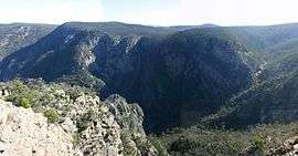 The Little River Gorge, located within the national park. | |
 Snowy River National Park | |
| Nearest town or city | Buchan |
| Coordinates | 37°16′30″S 148°33′12″E / 37.27500°S 148.55333°ECoordinates: 37°16′30″S 148°33′12″E / 37.27500°S 148.55333°E |
| Established | 26 April 1979[1] |
| Area | 987 km2 (381.1 sq mi)[1] |
| Managing authorities | Parks Victoria |
| Website | Snowy River National Park |
| See also | Protected areas of Victoria |
The Snowy River National Park is a national park located in the alpine and East Gippsland regions of Victoria, Australia. The 98,700-hectare (244,000-acre) national park is situated approximately 390 kilometres (240 mi) northeast of Melbourne and 350 kilometres (220 mi) southwest of Canberra, south of the Black-Allan Line that marks part of the border between Victoria and New South Wales.
On 7 November 2008, the park was added to the Australian National Heritage List as one of eleven areas constituting the Australian Alps National Parks and Reserves.[2]
Location and features
Declared on 26 April 1979, much of the park is classified as wilderness area, where vehicles are unable to visit.[1] Within the national park is the Little River Gorge, Victoria's deepest gorge, with the Little River descending 610 metres (2,000 ft) off the Wulgulmerang plateau over 14 kilometres (8.7 mi) to the Snowy River at an elevation of 122 metres (400 ft) above sea level.
The park provides one of the last natural habitats at the Little River Gorge for the endangered brush-tailed rock wallaby. Numbers for this species are estimated as extremely small, with the rugged terrain making it difficult to accurately monitor the species population. Over 250 native species have been recorded in the park, 29 of which are considered rare or threatened in Victoria, including the long-footed potoroo, spotted quoll (tiger quoll), giant burrowing frog and Cyclodomorphus michaeli.[3]
McKillops Road is the northern park boundary, with the Alpine National Park to the north of the road. The road is designated unsuitable for caravans, trailers and semi-trailers due to its long, narrow, and steep descent down to McKillops Bridge which crosses the Snowy River near its juncture with the Deddick River. A camping site near McKillops Bridge provides an excellent site for swimming, launching canoes and rafting through the rugged gorges downstream, or the start for the 18 km Silver Mine Walking Track and the short Snowy River Trail. The park is also located adjacent to the Errinundra National Park, the Coopracambra National Park, and the nearby Croajingolong National Park and Cape Conran Coastal Park.[1]
See also
- Australian Alps National Parks and Reserves
- Protected areas of Victoria (Australia)
- Snowy Mountains Scheme
References
- 1 2 3 4 "Snowy River National Park management plan" (PDF). Parks Victoria (PDF). Government of Victoria. May 1995. pp. 1–3. ISBN 0-7306-4099-X. Retrieved 26 August 2014.
- ↑ "Australian Alps National Parks information". Department of the Environment, Water, Heritage and the Arts. Retrieved 2010-06-10.
- ↑ "Snowy River National Park: park notes" (PDF). Parks Victoria. Government of Victoria. November 2013.
External links
| Wikimedia Commons has media related to Snowy River National Park. |
- "Snowy River National Park: Silver Mine Walking Track" (PDF). Parks Victoria. Government of Victoria.