Montbartier
| Montbartier | ||
|---|---|---|
 | ||
| ||
 Montbartier | ||
|
Location within Occitanie region  Montbartier | ||
| Coordinates: 43°54′49″N 1°16′24″E / 43.9136°N 1.2733°ECoordinates: 43°54′49″N 1°16′24″E / 43.9136°N 1.2733°E | ||
| Country | France | |
| Region | Occitanie | |
| Department | Tarn-et-Garonne | |
| Arrondissement | Montauban | |
| Canton | Montech | |
| Intercommunality | Garonne et Canal | |
| Government | ||
| • Mayor (2014–2020) | Jean-Claude Raynal | |
| Area1 | 15.01 km2 (5.80 sq mi) | |
| Population (2012)2 | 1,234 | |
| • Density | 82/km2 (210/sq mi) | |
| Time zone | CET (UTC+1) | |
| • Summer (DST) | CEST (UTC+2) | |
| INSEE/Postal code | 82123 / 82700 | |
| Elevation |
99–141 m (325–463 ft) (avg. 113 m or 371 ft) | |
|
1 French Land Register data, which excludes lakes, ponds, glaciers > 1 km² (0.386 sq mi or 247 acres) and river estuaries. 2 Population without double counting: residents of multiple communes (e.g., students and military personnel) only counted once. | ||
.svg.png)
Montbartier is a commune in the Tarn-et-Garonne department in the Occitanie region in southern France.
Monument
 The church
 War memorial
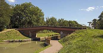 Bridge over the Canal Lateral à la Garonne, north exposure
See also
References
| Wikimedia Commons has media related to Montbartier. |
This article is issued from Wikipedia - version of the 11/12/2016. The text is available under the Creative Commons Attribution/Share Alike but additional terms may apply for the media files.