Verdun-sur-Garonne
| Verdun-sur-Garonne | ||
|---|---|---|
|
The clock tower in Verdun-sur-Garonne | ||
| ||
 Verdun-sur-Garonne | ||
|
Location within Occitanie region  Verdun-sur-Garonne | ||
| Coordinates: 43°51′14″N 1°14′11″E / 43.8539°N 1.2364°ECoordinates: 43°51′14″N 1°14′11″E / 43.8539°N 1.2364°E | ||
| Country | France | |
| Region | Occitanie | |
| Department | Tarn-et-Garonne | |
| Arrondissement | Montauban | |
| Canton | Verdun-sur-Garonne | |
| Intercommunality | Garonne et Gascogne | |
| Government | ||
| • Mayor | Aurélie Corbineau | |
| Area1 | 36.26 km2 (14.00 sq mi) | |
| Population (2010)2 | 4,112 | |
| • Density | 110/km2 (290/sq mi) | |
| Time zone | CET (UTC+1) | |
| • Summer (DST) | CEST (UTC+2) | |
| INSEE/Postal code | 82190 / 82600 | |
| Elevation |
90–166 m (295–545 ft) (avg. 110 m or 360 ft) | |
|
1 French Land Register data, which excludes lakes, ponds, glaciers > 1 km² (0.386 sq mi or 247 acres) and river estuaries. 2 Population without double counting: residents of multiple communes (e.g., students and military personnel) only counted once. | ||

.svg.png)
Verdun-sur-Garonne is a commune in the Tarn-et-Garonne department in the Occitanie region in southern France.
Monuments
 Town Hall
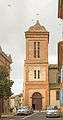 St. Michel Church
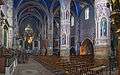 St. Michel Church
 The Market hall.
 War memorial
See also
References
| Wikimedia Commons has media related to Verdun-sur-Garonne. |
This article is issued from Wikipedia - version of the 11/12/2016. The text is available under the Creative Commons Attribution/Share Alike but additional terms may apply for the media files.