Mineville, New York
| Mineville, New York | |
|---|---|
| Census-designated place | |
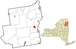 Location in Essex County and the state of New York | |
| Coordinates: 44°05′35″N 73°31′6″W / 44.09306°N 73.51833°WCoordinates: 44°05′35″N 73°31′6″W / 44.09306°N 73.51833°W | |
| Country | United States |
| State | New York |
| County | Essex |
| Town | Moriah |
| Area | |
| • Total | 3.71 sq mi (9.60 km2) |
| • Land | 3.70 sq mi (9.59 km2) |
| • Water | 0.008 sq mi (0.02 km2) |
| Elevation | 1,306 ft (398 m) |
| Population (2010) | |
| • Total | 1,269 |
| • Density | 343/sq mi (132.3/km2) |
| Time zone | Eastern (EST) (UTC-5) |
| • Summer (DST) | EDT (UTC-4) |
| ZIP code | 12956 |
| FIPS code | 36-47707 |
Mineville is a hamlet and census-designated place (CDP) in the town of Moriah in Essex County, New York, United States. The population was 1,269 at the 2010 census.[1] Prior to the 2010 census, it was part of the Mineville-Witherbee, New York census-designated place. Mineville and Witherbee are located in the northern part of Moriah, northwest of Port Henry. Mineville was named for the iron ore mines that used to operate here.
Geography
Mineville is located at 44°5′35″N 73°31′6″W / 44.09306°N 73.51833°W.[2] According to the United States Census Bureau, the CDP has a total area of 3.7 square miles (9.6 km2), of which 0.01 square miles (0.02 km2), or 0.17%, is water.[1]
The CDP is located along County Road 7 at the junction of County Road 6, 5 miles (8 km) northwest of Port Henry.
References
- 1 2 "Geographic Identifiers: 2010 Demographic Profile Data (G001): Mineville CDP, New York". U.S. Census Bureau, American Factfinder. Retrieved February 22, 2016.
- ↑ "US Gazetteer files: 2010, 2000, and 1990". United States Census Bureau. 2011-02-12. Retrieved 2011-04-23.
Municipalities and communities of Essex County, New York, United States | ||
|---|---|---|
| Towns | 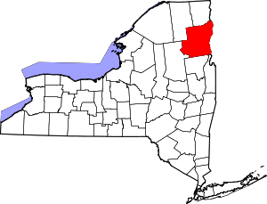 | |
| Villages | ||
| CDPs | ||
| Other hamlets | ||
| Footnotes | ‡This populated place also has portions in an adjacent county or counties | |