McLean Township, Shelby County, Ohio
| McLean Township, Shelby County, Ohio | |
|---|---|
| Township | |
|
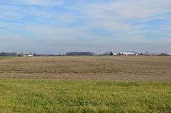
Farms west of Fort Loramie | |
 Location of McLean Township in Shelby County | |
| Coordinates: 40°21′47″N 84°22′11″W / 40.36306°N 84.36972°WCoordinates: 40°21′47″N 84°22′11″W / 40.36306°N 84.36972°W | |
| Country | United States |
| State | Ohio |
| County | Shelby |
| Area | |
| • Total | 33.5 sq mi (86.7 km2) |
| • Land | 32.3 sq mi (83.5 km2) |
| • Water | 1.2 sq mi (3.1 km2) |
| Elevation[1] | 958 ft (292 m) |
| Population (2000) | |
| • Total | 3,082 |
| • Density | 95.5/sq mi (36.9/km2) |
| Time zone | Eastern (EST) (UTC-5) |
| • Summer (DST) | EDT (UTC-4) |
| FIPS code | 39-46172[2] |
| GNIS feature ID | 1086965[1] |
McLean Township is one of the fourteen townships of Shelby County, Ohio, United States. The 2000 census found 3,082 people in the township, 1,738 of whom lived in the unincorporated portions of the township.[3]
Geography
Located in the western part of the county, it borders the following townships:
- Van Buren Township - northeast
- Turtle Creek Township - east
- Cynthian Township - south
- Patterson Township, Darke County - southwest
- Marion Township, Mercer County - west
- Jackson Township, Auglaize County - northwest, south of German Township
- German Township, Auglaize County - northwest corner, north of Jackson Township
The village of Fort Loramie is located in the center of the township.
Name and history
McLean Township was established in 1834.[4] It is the only McLean Township statewide.[5]
Government
The township is governed by a three-member board of trustees, who are elected in November of odd-numbered years to a four-year term beginning on the following January 1. Two are elected in the year after the presidential election and one is elected in the year before it. There is also an elected township fiscal officer,[6] who serves a four-year term beginning on April 1 of the year after the election, which is held in November of the year before the presidential election. Vacancies in the fiscal officership or on the board of trustees are filled by the remaining trustees.
References
- 1 2 "US Board on Geographic Names". United States Geological Survey. 2007-10-25. Retrieved 2008-01-31.
- ↑ "American FactFinder". United States Census Bureau. Archived from the original on September 11, 2013. Retrieved 2008-01-31.
- ↑ Shelby County, Ohio — Population by Places Estimates Ohio State University, 2007. Accessed 15 May 2007.
- ↑ Hitchcock, Almon Baldwin Carrington (1913). History of Shelby County, Ohio, and representative citizens. p. 84.
- ↑ "Detailed map of Ohio" (PDF). United States Census Bureau. 2000. Retrieved 2007-02-16.
- ↑ §503.24, §505.01, and §507.01 of the Ohio Revised Code. Accessed 4/30/2009.
External links
Municipalities and communities of Shelby County, Ohio, United States | ||
|---|---|---|
| City | 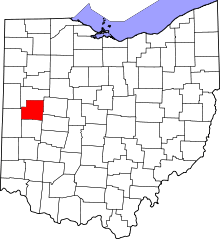 | |
| Villages | ||
| Townships | ||
| CDP | ||
| Unincorporated communities | ||