Lockington, Ohio
| Lockington, Ohio | |
|---|---|
| Village | |
|
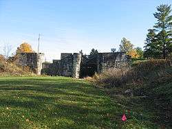
One of the Lockington Locks | |
 Location of Lockington, Ohio | |
 Location of Lockington in Shelby County | |
| Coordinates: 40°12′31″N 84°14′9″W / 40.20861°N 84.23583°WCoordinates: 40°12′31″N 84°14′9″W / 40.20861°N 84.23583°W | |
| Country | United States |
| State | Ohio |
| County | Shelby |
| Area[1] | |
| • Total | 0.08 sq mi (0.21 km2) |
| • Land | 0.08 sq mi (0.21 km2) |
| • Water | 0 sq mi (0 km2) |
| Elevation[2] | 948 ft (289 m) |
| Population (2010)[3] | |
| • Total | 141 |
| • Estimate (2012[4]) | 140 |
| • Density | 1,762.5/sq mi (680.5/km2) |
| Time zone | Eastern (EST) (UTC-5) |
| • Summer (DST) | EDT (UTC-4) |
| FIPS code | 39-44352[5] |
| GNIS feature ID | 1065016[2] |
Lockington is a village in Washington Township, Shelby County, Ohio, United States, along Loramie Creek. The population was 141 at the 2010 census.
History
Lockington was platted in 1837.[6] The village was incorporated in 1857.[6] A post office was established in Lockington on June 28, 1847, but it closed on August 30, 1914. Since that time, Lockington's mail has gone through the Piqua post office.[7]
Founded as "Locksport"[8] and located along the old Miami and Erie Canal, Lockington was named for its location by a series of canal locks.[9] It sat at the junction of the main canal with a feeder coming from Port Jefferson and Sidney.
Geography
Lockington is located at 40°12′31″N 84°14′9″W / 40.20861°N 84.23583°W (40.208681, -84.235779).[10] According to the United States Census Bureau, the village has a total area of 0.08 square miles (0.21 km2), all land.[1]
Demographics
| Historical population | |||
|---|---|---|---|
| Census | Pop. | %± | |
| 1870 | 214 | — | |
| 1880 | 219 | 2.3% | |
| 1890 | 170 | −22.4% | |
| 1900 | 210 | 23.5% | |
| 1910 | 166 | −21.0% | |
| 1920 | 181 | 9.0% | |
| 1930 | 174 | −3.9% | |
| 1940 | 192 | 10.3% | |
| 1950 | 245 | 27.6% | |
| 1960 | 263 | 7.3% | |
| 1970 | 242 | −8.0% | |
| 1980 | 203 | −16.1% | |
| 1990 | 214 | 5.4% | |
| 2000 | 208 | −2.8% | |
| 2010 | 141 | −32.2% | |
| Est. 2015 | 139 | [11] | −1.4% |
2010 census
As of the census[3] of 2010, there were 141 people, 56 households, and 42 families residing in the village. The population density was 1,762.5 inhabitants per square mile (680.5/km2). There were 64 housing units at an average density of 800.0 per square mile (308.9/km2). The racial makeup of the village was 97.9% White, 0.7% Asian, and 1.4% from two or more races. Hispanic or Latino of any race were 0.7% of the population.
There were 56 households of which 28.6% had children under the age of 18 living with them, 60.7% were married couples living together, 5.4% had a female householder with no husband present, 8.9% had a male householder with no wife present, and 25.0% were non-families. 21.4% of all households were made up of individuals and 5.4% had someone living alone who was 65 years of age or older. The average household size was 2.52 and the average family size was 2.81.
The median age in the village was 44.8 years. 22% of residents were under the age of 18; 5.7% were between the ages of 18 and 24; 22.8% were from 25 to 44; 38.3% were from 45 to 64; and 11.3% were 65 years of age or older. The gender makeup of the village was 53.9% male and 46.1% female.
2000 census
As of the census[5] of 2000, there were 208 people, 74 households, and 60 families residing in the village. The population density was 2,494.0 people per square mile (1,003.9/km²). There were 77 housing units at an average density of 923.3 per square mile (371.6/km²). The racial makeup of the village was 97.12% White, 2.40% African American and 0.48% Native American. Hispanic or Latino of any race were 1.44% of the population.
There were 74 households out of which 39.2% had children under the age of 18 living with them, 64.9% were married couples living together, 12.2% had a female householder with no husband present, and 17.6% were non-families. 16.2% of all households were made up of individuals and 5.4% had someone living alone who was 65 years of age or older. The average household size was 2.81 and the average family size was 3.11.
In the village the population was spread out with 26.9% under the age of 18, 12.0% from 18 to 24, 27.4% from 25 to 44, 24.0% from 45 to 64, and 9.6% who were 65 years of age or older. The median age was 36 years. For every 100 females there were 101.9 males. For every 100 females age 18 and over, there were 102.7 males.
The median income for a household in the village was $37,500, and the median income for a family was $39,500. Males had a median income of $25,694 versus $21,000 for females. The per capita income for the village was $15,374. About 9.4% of families and 7.5% of the population were below the poverty line, including 11.7% of those under the age of eighteen and none of those sixty-five or over.
References
| Wikimedia Commons has media related to Lockington, Ohio. |
- 1 2 "US Gazetteer files 2010". United States Census Bureau. Retrieved 2013-01-06.
- 1 2 "US Board on Geographic Names". United States Geological Survey. 2007-10-25. Retrieved 2008-01-31.
- 1 2 "American FactFinder". United States Census Bureau. Retrieved 2013-01-06.
- ↑ "Population Estimates". United States Census Bureau. Retrieved 2013-06-17.
- 1 2 "American FactFinder". United States Census Bureau. Retrieved 2008-01-31.
- 1 2 Hitchcock, Almon Baldwin Carrington (1913). History of Shelby County, Ohio, and representative citizens. p. 393.
- ↑ U.S. Geological Survey Geographic Names Information System: Lockington Post Office
- ↑ "Travel back in time: Discover Ohio's Miami and Erie Canal" (PDF). Ohio Department of Natural Resources, Division of Water. p. 22.
|chapter=ignored (help) - ↑ Overman, William Daniel (1958). Ohio Town Names. Akron, OH: Atlantic Press. p. 76.
- ↑ "US Gazetteer files: 2010, 2000, and 1990". United States Census Bureau. 2011-02-12. Retrieved 2011-04-23.
- ↑ "Annual Estimates of the Resident Population for Incorporated Places: April 1, 2010 to July 1, 2015". Retrieved July 2, 2016.
- ↑ "Census of Population and Housing". Census.gov. Retrieved June 4, 2015.
Municipalities and communities of Shelby County, Ohio, United States | ||
|---|---|---|
| City | 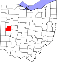 | |
| Villages | ||
| Townships | ||
| CDP | ||
| Unincorporated communities | ||