Marmaton Township, Bourbon County, Kansas
| Marmaton Township | |
|---|---|
| Township | |
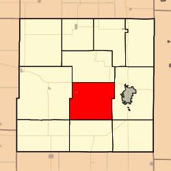 Location in Bourbon County | |
| Coordinates: 37°48′45″N 094°49′21″W / 37.81250°N 94.82250°WCoordinates: 37°48′45″N 094°49′21″W / 37.81250°N 94.82250°W | |
| Country | United States |
| State | Kansas |
| County | Bourbon |
| Area | |
| • Total | 56.11 sq mi (145.34 km2) |
| • Land | 56.04 sq mi (145.14 km2) |
| • Water | 0.08 sq mi (0.2 km2) 0.14% |
| Elevation | 820 ft (250 m) |
| Population (2000) | |
| • Total | 815 |
| • Density | 14.5/sq mi (5.6/km2) |
| GNIS feature ID | 0474758 |
Marmaton Township is a township in Bourbon County, Kansas, USA. As of the 2000 census, its population was 815.
History
Marmaton is a corruption of Marmiton, a French name given by fur traders meaning "scullion".[1]
Geography
Marmaton Township covers an area of 56.11 square miles (145.3 km2) and contains one incorporated settlement, Redfield. According to the USGS, it contains two cemeteries: Marmaton and Woods.
The streams of Bunion Creek, Cedar Creek, Chambers Branch, Elm Creek, Paint Creek, Pawnee Creek and Robinson Branch run through this township.
Transportation
Marmaton Township contains one airport or landing strip, Fort Scott Municipal Airport.
Further reading
References
- ↑ Robley, T. F. (1894). History of Bourbon County, Kansas: To the Close of 1865. Press of the Monitor book & printing Company. p. 98.
External links
- City-Data.com
- Bourbon County Maps: Current, Historic Collection
Municipalities and communities of Bourbon County, Kansas, United States | ||
|---|---|---|
| Cities |  | |
| Unincorporated communities | ||
| Townships | ||
This article is issued from Wikipedia - version of the 11/3/2016. The text is available under the Creative Commons Attribution/Share Alike but additional terms may apply for the media files.