Drywood Township, Bourbon County, Kansas
| Drywood Township | |
|---|---|
| Township | |
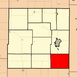 Location in Bourbon County | |
| Coordinates: 37°43′00″N 094°41′11″W / 37.71667°N 94.68639°WCoordinates: 37°43′00″N 094°41′11″W / 37.71667°N 94.68639°W | |
| Country | United States |
| State | Kansas |
| County | Bourbon |
| Area | |
| • Total | 46.59 sq mi (120.67 km2) |
| • Land | 46.5 sq mi (120.44 km2) |
| • Water | 0.09 sq mi (0.23 km2) 0.19% |
| Elevation | 922 ft (281 m) |
| Population (2000) | |
| • Total | 394 |
| • Density | 8.5/sq mi (3.3/km2) |
| GNIS feature ID | 0474803 |
Drywood Township is a township in Bourbon County, Kansas, USA. As of the 2000 census, its population was 394.
Geography
Drywood Township covers an area of 46.59 square miles (120.7 km2) and contains no incorporated settlements. According to the USGS, it contains five cemeteries: Howard, Mayfield, Pine Lawn, Pleasant View and Tweedy.
The streams of Cox Creek and Walnut Creek run through this township.
Further reading
References
External links
- City-Data.com
- Bourbon County Maps: Current, Historic Collection
Municipalities and communities of Bourbon County, Kansas, United States | ||
|---|---|---|
| Cities |  | |
| Unincorporated communities | ||
| Townships | ||
This article is issued from Wikipedia - version of the 6/5/2014. The text is available under the Creative Commons Attribution/Share Alike but additional terms may apply for the media files.