Marienthal, Kansas
| Marienthal, Kansas | |
|---|---|
| census-designated place | |
 Marienthal, Kansas Location within the state of Kansas | |
| Coordinates: 38°29′15″N 101°12′47″W / 38.48750°N 101.21306°WCoordinates: 38°29′15″N 101°12′47″W / 38.48750°N 101.21306°W[1] | |
| Country | United States |
| State | Kansas |
| County | Wichita |
| Elevation[1] | 3,215 ft (980 m) |
| Time zone | Central (CST) (UTC-6) |
| • Summer (DST) | CDT (UTC-5) |
| ZIP codes | 67863 |
| Area code(s) | 620 |
| FIPS code | 20-44600 [1] |
| GNIS feature ID | 471501 [1] |
Marienthal is an unincorporated community in Wichita County, Kansas, United States. It is also the locus of, and its name is used to identify, a census-designated place in Kansas.
History
In 1892, the community was founded by a group of immigrant Germans from Russia; they named it after their previous hometown of Marienthal, Russia, today Marienka, Ukraine. The post office was established March 18, 1902.[2] Marienthal now consists of roughly 100 people, a Catholic church,[3] a post office, a flour mill,[4] a substance abuse treatment center, a trucking company, a bar and a grain elevator.
References
- 1 2 3 4 GNIS for Marienthal, Kansas; USGS; October 13, 1978.
- ↑ "Kansas Post Offices, 1828-1961". Kansas Historical Society. Archived from the original on October 9, 2013. Retrieved 27 June 2014.
- ↑ St. Mary Church.
- ↑ Heartland Mill.
External links
Municipalities and communities of Wichita County, Kansas, United States | ||
|---|---|---|
| City | 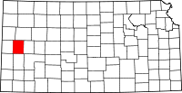 | |
| CDP | ||
| Unincorporated communities | ||
| Ghost towns | ||
This article is issued from Wikipedia - version of the 3/31/2016. The text is available under the Creative Commons Attribution/Share Alike but additional terms may apply for the media files.