Mapandan, Pangasinan
| Mapandan | ||
|---|---|---|
| Municipality | ||
|
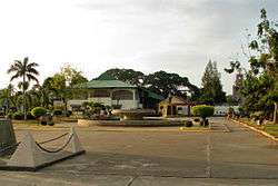
Poblacion and Municipal Hall | ||
| ||
| Nickname(s): Town of the Happy Faces | ||
| Motto: "aligwas Mapandan!" (Improving Mapandan!) | ||
 Map of Pangasinan showing the location of Mapandan | ||
.svg.png) Mapandan Location within the Philippines | ||
| Coordinates: 16°01′N 120°27′E / 16.017°N 120.450°ECoordinates: 16°01′N 120°27′E / 16.017°N 120.450°E | ||
| Country |
| |
| Region | Ilocos (Region I) | |
| Province | Pangasinan | |
| District | 3rd district of Pangasinan | |
| Barangays | 15 | |
| Government[1] | ||
| • Mayor | Maximo M. Calimlim Jr. | |
| Area[2] | ||
| • Total | 30.00 km2 (11.58 sq mi) | |
| Population (2010)[3] | ||
| • Total | 34,439 | |
| • Density | 1,100/km2 (3,000/sq mi) | |
| Time zone | PST (UTC+8) | |
| ZIP code | 2429 | |
| Dialing code | 75 | |
| Income class | 2nd class; rural | |

Mapandan is a second class municipality in the province of Pangasinan, Philippines. According to the 2010 census, it has a population of 34,439 people.[3]
Mapandan is a Hall of Famer for having the Pangasinan's cleanest, safest and greenest municipality (Category B). Mapandan was also awarded the Pangasinan's Healthiest Municipality for having the least number of malnourished children.
Mapandan is known for its yearly Pandan Festival.
Etymology
The municipality was formerly a barrio of Mangaldan. It was conceived into a municipality in 1909. Mapandan (meaning plenty of pandan) got its name from “pandan”, a native palm which grew in abundance in the place at that time. The leaves of the pandan add aroma to the cooked rice if cooked with it. The leaves are also stripped and woven into mats.
Geography
Mapandan is located in Eastern-Central part of Pangasinan.Bordered by Mangaldan to the north, Manaoag to the east, and Sta. Barbara to the west and southern part.
Mapandan is landlocked, however, it is not too far from nearby coastal areas of Dagupan City, Binmaley and Mangaldan.
Mapandan is located in central hilly area,having several mountains nearby.
It has a little part of Bued river in northern part and an irrigation project also known as Payas irrigation project, which aims for a standard irrigation for farming areas in the municipality.
History
Mapandan was a former mere Barrio. That was former part of Municipality of Mangaldan.
It is composed of farming areas and cattle ranch farms.
Mapandan is practically rural in terms of its area.
Barangays
Mapandan is politically subdivided into 15 barangays:[2]
- Amanoaoac
- Apaya
- Aserda
- Baloling
- Coral
- Golden
- Jimenez
- Lambayan
- Luyan
- Nilombot
- Pias
- Poblacion
- Primicias
- Santa Maria
- Torres
Demographics
| Population census of Mapandan | ||
|---|---|---|
| Year | Pop. | ±% p.a. |
| 1990 | 25,622 | — |
| 1995 | 27,439 | +1.29% |
| 2000 | 30,775 | +2.49% |
| 2007 | 32,905 | +0.93% |
| 2010 | 34,439 | +1.67% |
| 2015 | 37,059 | +1.41% |
| Source: National Statistics Office[3][4] | ||
Dialects
Pangasinan and Ilocano are the main dialects in the town, second is the Kapampangan dialect. Filipino-Tagalog based is also spoken in the town.
Religions
Major religions are in the town.With different branches of churches within.
- Iglesia ni Cristo (Nilombot)
- The Grand Mosque (Luyan)
- The Church of Jesus Christ of Latter Day Saints (Nilombot)
- Kingdom hall of Jehovas Witnesses (Coral)
- Roman Catholicism (Poblacion and Luyan)
- Good news to the Nations Outreach (Poblacion)
- Born Again Christianity (Poblacion)
Roman Catholicism is the major Religion in Mapandan,annexed by different religions around.
Climate
| Climate data for Mapandan, Pangasinan | |||||||||||||
|---|---|---|---|---|---|---|---|---|---|---|---|---|---|
| Month | Jan | Feb | Mar | Apr | May | Jun | Jul | Aug | Sep | Oct | Nov | Dec | Year |
| Average high °C (°F) | 29 (84) |
29 (84) |
30 (86) |
32 (90) |
33 (91) |
33 (91) |
33 (91) |
33 (91) |
33 (91) |
32 (90) |
31 (88) |
29 (84) |
31.4 (88.4) |
| Average low °C (°F) | 21 (70) |
21 (70) |
22 (72) |
23 (73) |
24 (75) |
24 (75) |
23 (73) |
24 (75) |
23 (73) |
23 (73) |
22 (72) |
21 (70) |
22.6 (72.6) |
| Average precipitation mm (inches) | 127.5 (5.02) |
115.8 (4.559) |
129.7 (5.106) |
141.1 (5.555) |
248.2 (9.772) |
165 (6.5) |
185.3 (7.295) |
161.9 (6.374) |
221.4 (8.717) |
299.5 (11.791) |
199 (7.83) |
188.7 (7.429) |
2,183.1 (85.948) |
| Average rainy days | 17 | 17 | 17 | 15 | 20 | 19 | 19 | 20 | 21 | 20 | 17 | 19 | 221 |
| Source: World Weather Online[5] | |||||||||||||
Partner Cities
These are cities Mapandan are associated with:
References
- ↑ "Municipalities". Quezon City, Philippines: Department of the Interior and Local Government. Retrieved 26 November 2012.
- 1 2 "Province: PANGASINAN". PSGC Interactive. Makati City, Philippines: National Statistical Coordination Board. Retrieved 26 November 2012.
- 1 2 3 "Total Population by Province, City, Municipality and Barangay: as of May 1, 2010" (PDF). 2010 Census of Population and Housing. National Statistics Office. Retrieved 26 November 2012.
- ↑ "Province of Pangasinan". Municipality Population Data. LWUA Research Division. Retrieved 5 September 2013.
- ↑ "Mapandan, Pangasinan: Average Temperatures and Rainfall". World Weather Online. Retrieved 12 October 2015.
External links
| Wikimedia Commons has media related to Mapandan, Pangasinan. |
- Philippine Standard Geographic Code
- Philippine Census Information
- Local Governance Performance Management System
 |
Mangaldan | San Jacinto | Manaoag | |
| |
||||
| ||||
| | ||||
| Santa Barbara | |
Urdaneta City |
Lingayen (capital) | |
| Municipalities |
|
| Component cities | |
| Independent component city |
|
| Barangays | |