Mandalay District
| Mandalay District မန္တလေး ခရိုင် | |
|---|---|
| District of Mandalay Division | |
| Mandalay District | |
 Mandalay District Location in Burma | |
| Coordinates: 21°58′0″N 96°05′0″E / 21.96667°N 96.08333°E | |
| Country | Myanmar |
| Division | Mandalay |
| Time zone | MST (UTC6:30) |
| Area code(s) | 2 (mobile: 69, 90)[1] |
Mandalay District (Burmese: မန္တလေး ခရိုင်) is a district of the Mandalay Division in central Myanmar. Though the district used to consist of two cities, Mandalay and Amarapura, today, with the urban sprawl of Mandalay capturing Amarapura and Patheingyi, the district and the city of Mandalay are one and the same.
Townships
The Mandalay District consists of the following townships.
- Amarapura Township
- Aungmyethazan Township
- Chanayethazan Township
- Chanmyathazi Township
- Mahaaungmye Township
- Patheingyi Township
- Pyigyidagun Township
References
Coordinates: 21°58′N 96°05′E / 21.967°N 96.083°E
Capital: Mandalay | ||
| Kyaukse District |  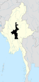 | |
| Mandalay District | ||
| Meiktila District | ||
| Myingyan District | ||
| Nyaung-U District |
| |
| Pyinoolwin District |
| |
| Yamethin District | ||
| Main cities and towns | ||
| States | ||
|---|---|---|
| Regions | ||
| Self-Administered Zones | ||
| Self-Administered Divisions | ||
| Union Territories | ||
This article is issued from Wikipedia - version of the 8/18/2015. The text is available under the Creative Commons Attribution/Share Alike but additional terms may apply for the media files.