Manaung Township
| Manaung Township မာန်အောင်မြို့နယ် | |
|---|---|
| Township | |
| Country |
|
| State | Rakhine State |
| District | Kyaukpyu District |
| Time zone | MST (UTC+6:30) |
Manaung Township (Burmese: မာန်အောင်မြို့နယ်) is a township of Kyaukpyu District in the Rakhine State of Western Myanmar. The principal town is Manaung. Manaung Township, situated on Manaung Island consists of three islands: Manaung Island, Ye Kyun Island and Taik Kyu Island. Manaung is not only a township of Kyaukpyu District but also the second biggest island of Rakhine State in Myanmar.
There are Bay of Bengal in the West and Northwest, Ramree Island in the Northeast, Ye Kyun Island in the South and Taungup in the East. Manaung Island, about 55 miles in circumference, is situated at 18'47 (898'N) and 93'98 (472'E) in the Rakhine Coast of Myanmar.
The highest mountain is 972 feet (296 m) high and the lowest level is 6 feet (1.8 m) above sea level. Manaung Township is 202.05 square mile (Area 120309) wide. The population was 95927 on October 31, 2007.
There are 5 wards and 138 villages in Manaung Township.
Manaung Township has 94724 of Rakhine, 937 of Chin, 3 of Myo, 2 of Kame, 236 of Bamar, 2 of Dinae, 1 of Thet, 24 of Kayin, 2 of Kayah and 6 of Shan. Religion has only Buddhist. There are 63 pagodas and 27 buddhist images. There are 180 monks, 178 novices and 22 nuns.
There is one township stadium.MrNN.
 Entry Point of Manaung
 Manaung Township Passenger Transportation
 Manaung Township Timber Business
 Manaung Township Goods Transportation
 Manaung Township Agriculture
.jpg) Manaung Township Communication
Manaung Township Communication Manaung Township Business
Education
There are 7 high schools, 11 middle schools and 106 elementary schools. There is one nusery school. There are 127 librarys.
List of Township Administrators
- U Tin Than 18-9-1988 to 19-11-1991
- U Mya Than 19-11-1991 to 7-11-1992
- U Maung Than 7-11-1992 to 12-8-1993
- U Oo tun Aung 12-8-1993 to 3-7-1998
- U Han Soe 3-7-1998 to 15-9-1998
- U Sai Maung Nyi 15-9-1998 to 14-1-1999
- U Pot (aka) Thar Moe 14-1-1999 to 7-11-2001
- U Tun San Win 7-11-2001 to 25-7-2002
- U Hla Thein 19-9-2001 to 9-12-2004
- U Naing Tun 9-12-2004 to 16-8-2007
- U Nyi Nyi Lwin 16-8-2007 to present
See also
- Manaung Township Association (Yangon)
Capital: Sittwe | ||
| Kyaukpyu District |  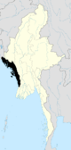 | |
| Maungdaw District | ||
| Sittwe District | ||
| Thandwe District |
| |
| Mrauk-U District | ||
| Main cities and towns | ||
Coordinates: 18°51′00″N 93°44′00″E / 18.8500°N 93.7333°E