Kyeintali
| Kyeintali ကျိန္တလီမြို့ | |
|---|---|
| Town | |
| Kyeintali | |
|
Sign seen upon entering Kyeintali from Yangon. The sign reads: "A warm welcome from Kyeintali." | |
 Kyeintali Location in Myanmar (Burma) | |
| Coordinates: 18°00′22″N 94°29′24″E / 18.00611°N 94.49000°E | |
| Country |
|
| State | Rakhine |
| Township | Gwa |
| Subtownship | Kyeintali |
| Population (2014) | |
| • Town | 23,581[1] |
| • Urban | 5,878 |
| Time zone | MMT (UTC6:30) |
| Postal code | 07182 |

Kyeintali (Burmese: ကျိန္တလီ) is a town located in Gwa Township of Rakhine State, Myanmar (Burma).
Travel Suggestion
Around Kyeintali you will find beaches, plains and mountains, charming villages and towns, delicious food, bustling markets, incredible biodiversity, and, best of all, friendly, hospitable Rakhine people. This area provides ample opportunities for Swimming, Hiking and Birdwatching.
A simple, family-run guesthouse in Kyeintali can accommodate a small number of visitors. Local guides can take you on a range of activities, including bird-watching, hiking, and exploring nearby fishing villages, learning about local life. You’ll also have the chance to soak up the sun on the beautiful and untouched nearby beaches.
Kyeintali is a 40 km bus or taxi ride south of Ngapali Beach, or a long bus ride from Yangon. More information including contacts for booking can be found on the Rakhine Coastal Region Conservation Association website.[2]
Natural Resources
Macrognathus pavo A species included in The IUCN Red List of Threatened Species, Macrognathus pavo ,is only known from Kyeintali Chaung (stream) in the Rakhine Yoma, Myanmar. It only known from the headwaters of the type locality stream, and is likely restricted to that basin. Macrognathus pavo was described in 2010 and further information is required on the species habitat and ecology, as well as population and distribution. It is currently assessed as Data Deficient.[3] [4]
Kyeintali River Bridge
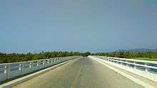
Jan. 1: The K 58.7 million Kyeintali River Bridge on the Thandwe-Gwa Road in Rakhine State was inaugurated by Minister for Progress of Border Areas and National Races and Development Affairs Lt-Gen. Maung Thint and SLORC Secretary-1 Lt-Gen. Khin Nyunt. (NLM 1/2)[5]
References
- ↑ "Population of Myanmar". Ministry of Immigration and Population (Myanmar) (in Burmese). 2014-03-29. Retrieved 9 April 2016.
- ↑ http://myanmar.travel/activity-myanmar/kyeintali/
- ↑ http://dx.doi.org/10.2305/IUCN.UK.2010-4.RLTS.T174506A7081279.en
- ↑ http://www.mmtimes.com/index.php/sports/5511-2013-06-07-07-53-57.html
- ↑ http://www.ibiblio.org/obl/docs3/95-01.txt
External links
Capital: Sittwe | ||
| Kyaukpyu District |  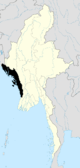 | |
| Maungdaw District | ||
| Sittwe District | ||
| Thandwe District |
| |
| Mrauk-U District | ||
| Main cities and towns | ||
Coordinates: 18°00′22″N 94°29′24″E / 18.00611°N 94.49000°E