Ménaka Cercle
| Ménaka | |
|---|---|
| Cercle | |
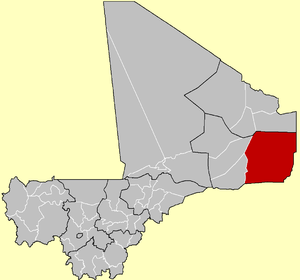 Ménaka Cercle in Mali | |
| Country |
|
| Region | Gao Region |
| Admin HQ (Chef-lieu) | Ménaka |
| Area | |
| • Total | 73,664 km2 (28,442 sq mi) |
| Population (2009 Census)[1] | |
| • Total | 56,104 |
| • Density | 0.76/km2 (2.0/sq mi) |
| Time zone | GMT (UTC+0) |
Ménaka Cercle is an administrative subdivision of the Gao Region of Mali. Its administrative center is the town of Ménaka. Ménaka Cercle's population as of 2009 was 56,104 people. Ménaka Cercle is a rural, isolated, and largely desert area, crisscrossed by seasonal wadis, part of an ancient dry river system of the Azawagh region (the Iullemmeden Basin). The area includes the rocky outcrops of the Ader Douchi hills. Most of the small population are nomadic are Tuareg tribal populations, as well as nomadic minorities, including the Wodaabe Fula and sedentary Songhai people. The area is a traditional center of the Kel Dinnik Tuareg confederation, with the town of Andéramboukane, near the Nigerien border, being one historic center for transhumance communities.[2] During the 2012 Tuareg rebellion, it was part of Azawad, the northern part of Mali that was separated and declared independent by the National Movement for the Liberation of Azawad (MNLA). In the course of the conflict, the MNLA lost their control of the territory to Islamist militias. On March 6, 2013, the Islamists lost control of the village of Tin Keraten, a village directly next to the Gao Cercle, and near the border of the Ansongo Cercle, to French and Malian troops in the Battle of Tin Keraten, becoming the first village in the Ménaka Cercle to come under allied control during the war.
The cercle is divided into five communes:[3]
2009 kidnappings
On 22 January, four foreign tourists were reported kidnapped in Ménaka Cercle, while traveling by auto from a festival at Anderamboukané on the main road to Ménaka, and on to Gao. One Briton, one German, and two Swiss citizens were reportedly kidnapped. One of their vehicles escaped the attack, and one which was seized was later found abandoned across the border near Bani-Bangou, Niger.[4][5][6][7] The German and one of the Swiss citizens were released in April 2009. The Briton was killed in May 2009. The other Swiss citizen was released in July 2009.[8]
On 25 November, a Frenchman called Pierre Camatte was taken hostage from a hotel in Ménaka city. A January 2010 statement issued by the north African branch of al-Qaeda, sets an ultimatum of 20 days for the exchange of four of al-Qaeda members by Pierre Camatte, after which, it says, the French and Malian governments "will be fully responsible for the French hostage's life". Camatte was released in exchange for the four prisoners in February 2010.[9]
References
- ↑ Resultats Provisoires RGPH 2009 (Région de Gao) (PDF) (in French), République de Mali: Institut National de la Statistique.
- ↑ Imperato, Pascal James (1986). Historical Dictionary of Mali. Metuchen NJ - London: Scarecrow Press. ISBN 0-8108-1369-6.:pp. 85, 144–145, 193
- ↑ Loi N°99-035/ du 10 Aout 1999 Portant Création des Collectivités Territoriales de Cercles et de Régions (PDF) (in French), Ministère de l'Administration Territoriales et des Collectivités Locales, République du Mali, 1999.
- ↑ Tourists 'kidnapped in Niger'. January 22, 2009. AFP.
- ↑ Mali - Niger. Des touristes européens enlevés au Niger. January 22, 2009. Afrik
- ↑ European tourists seized in Niger. 23 January 2009. Al Jazeera.
- ↑ Mali says Tuareg rebels abduct group of tourists. Thu Jan 22, 2009. Reuters.
- ↑ Swiss hostage released by al-Qaeda, Radio Netherlands Worldwide, 12 Jul 2009, retrieved 10 Feb 2011.
- ↑ Frenchman Pierre Camatte kidnapped in Mali, BBC News, 11 Jan 2010, retrieved 10 Feb 2011.
External links
- Synthèsis des Plans de Securité Alimentaire des Communes du Cercle de Ménaka 2005-2009 (PDF) (in French), Commissariat à la Sécurité Alimentaire, République du Mali, USAID-Mali, 2005.
- Schéma d'aménagement du territoire de Menaka (in French), Adere Nord, République du Mali, 2008.
| Kayes Region |  | |
|---|---|---|
| Koulikoro Region | ||
| Sikasso Region | ||
| Ségou Region | ||
| Mopti Region | ||
| Tombouctou Region | ||
| Gao Region | ||
| Kidal Region | ||
| Bamako Capital District | ||

Coordinates: 16°35′N 2°50′E / 16.583°N 2.833°E