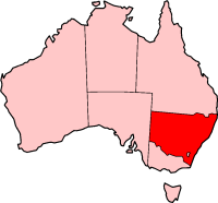
List of road routes in New South Wales
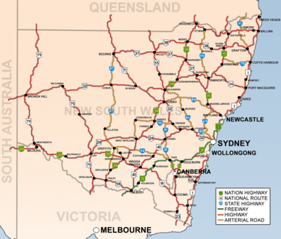
Road routes in New South Wales assist drivers navigating roads in urban, rural, and scenic areas of the state. Today, all numbered routes in the state are allocated a letter (M, A or B) in addition to a one- or -two digit number, with 'M' routes denoting motorways, 'A' routes denoting routes of national significance, and 'B' routes denoting routes of state significance. The route system includes the officially designated highways, urban and intercity motorways and arterial roads, and important cross-state roads that have not been declared highways.
History
Route numbers have been allocated to NSW roads since 1955. National Route 1 ('Highway 1') was one of the best known numbered national routes, likely because of its fame for circumnavigating the continent. The insignia of national routes was a five-sided black and white shield, chosen as it is the shape of the Australian national coat of arms.
To supplement the national route number system, three ring roads were introduced to Sydney in 1964.[1] These were numbered 1, 3 and 5, with relatively (but not proportionately) increasing radii. While they were officially decommissioned in 1974, some old ring road 3 signs remained posted into the 1980s, and ring road 1 signs into the 1990s.
In 1973, a system of freeway numbering was introduced to the state to complement the national routes and ring roads. The shields were replicas of the red, white and blue U.S. Interstate Highway shields, and were numbered F1 to F8. The F1 was the Warringah Freeway, the F2 reserved for the Castlereagh Freeway, a corridor similar to today's M2 Hills Motorway, the F3 is the Pacific Motorway (Sydney–Newcastle section), the F4 was the western part of today's M4 Western Motorway (formerly Western Freeway), the F5 was the freeway section of National Highway 31, the F6 is the Southern Freeway, the F7 was reserved for a corridor similar to today's Cahill Expressway, Eastern Distributor and Bondi Junction Bypass and the F8 was a section of Wollongong's Northern Distributor,[2] now part of State Route 60. Most of these routes were replaced with other numbers over the decades, and by the 1990s, only the F1, F3 and F6 were still marked as such, with simpler, green-on-white shields. None of these shields remain, but the F3 and F6 are still usually called by those names.
In 1974, the National Highway network was defined, which in New South Wales included the Hume Highway, Federal Highway, Barton Highway, Sydney-Newcastle Freeway (now Pacific Motorway) and New England Highway.[3] National highways were marked with the same shield as the national routes, except for their green and gold colour and the word 'national' added across the top.
Also in 1974, the three ring roads, 1, 3 and 5, were decommissioned and replaced by new State Routes, which had the same shields as the new freeways but without the red crest. Scores of other State Routes were also designated across New South Wales, marking out urban arterial routes and secondary rural highways. They were allocated as follows:
- 11, 33 and 55: Respectively replaced ring roads 1, 3 and 5. In 1988, state route 77 was commissioned as an additional primary circumferential route.
- 12-76: Greater Sydney. Even numbers were radial while odd numbers were circumferential, roughly increasing in value anticlockwise around the City. Exceptions were State Route 31 (which replaced Metroad 5 when the South Western Motorway was extended easterly; Metroad 5 was a replacement of the metropolitan part of National Highway 31) and state route 60 (which is in Wollongong). Routes 36, 40, 56, 68 and 69 extended beyond the bounds of Greater Sydney. While most State Routes still appear on maps and in street directories, they were haphazardly removed and covered up in Sydney in 1998 and 2004, leaving only routes 29, 31, 40, 44, 54, 56, 60 and 69.
- 78-99: Rural Areas. There was no discernible pattern with these routes. State route 83 was commissioned in 1979 and state route 89 was commissioned in 1980.
- 111, 121-124, 128, 131-133, 135: Greater Newcastle. 111 was added in 1988 following National Highway 1's relocation to the F3 Freeway.
- 151, 153, 155 and 157: Greater Wollongong, in addition to state routes 60, 68, 69 and 88.
- 2: In 2008, Queensland's state route 2 from the Gold Coast was extended a short distance into far northern NSW.
In 1993, Sydney's Metroad system was introduced, with its prominent, blue-on-white hexagonal shields. There were initially six metroads: Metroad 1 replaced National Route 1 within the metropolitan area, Metroad 2 replaced parts of State Routes 28 and 30 (and was subsequently absorbed by the M2 Hills Motorway), Metroad 3 replaced State Route 33 (once Ring Road 3), Metroad 4 replaced the F4 Freeway and the metropolitan part of National Route 32, Metroad 5 replaced part of the metropolitan part of National Highway 31 and Metroad 7 replaced State Route 77. Later, Metroad 6 replaced State Route 45, Metroad 9 replaced the metropolitan part of State Route 69 and Metroad 10 replaced State Route 14 south of Mona Vale. There was never a Metroad 8.
In 2013, the state replaced its entire system of State Routes, National Routes, National Highways and Metroads with an alphanumeric route numbering system. All numbered routes are allocated a letter (M, A or B) in addition to its number, with 'M' routes denoting motorways, 'A' routes denoting routes of national significance, and 'B' routes denoting routes of state significance. Instead of shields, the route numbers are displayed as yellow text on green rectangular background outlined in white. Unlike other Australian states, New South Wales's implementation of alphanumeric route numbers no longer uses National Highway shields on any route. The changeover to alphanumeric routes was announced from March 2013 and signs were updated throughout 2013, either by removing old "shield" coverplates installed on newer signs, or installing new alphanumeric coverplates on old shielded signs.
Motorways (M routes)
| Route | Component roads | From | Via | To | Length | Notes |
|---|---|---|---|---|---|---|
M1 |
Pacific Motorway | Queensland border | Ewingsdale | 56 km (35 mi) | ||
| Pacific Motorway | Newcastle | Wahroonga | 127 km (79 mi) | |||
| Gore Hill Freeway | Artarmon | Naremburn | 3 km (2 mi) | |||
| Warringah Freeway | Naremburn | North Sydney | 4 km (2 mi) | |||
| Sydney Harbour Tunnel | North Sydney | Sydney (City) | 2.8 km (2 mi) | |||
| Cahill Expressway | Sydney | Woolloomooloo | 900 m (984 yd) | |||
| Eastern Distributor | Woolloomooloo | Kensington | 6 km (4 mi) | |||
| Princes Motorway | Waterfall | Yallah | 53 km (33 mi) | |||
M2 |
Lane Cove Tunnel | Artarmon | North Ryde | 3.6 km (2 mi) | ||
| Hills Motorway | North Ryde |
|
Seven Hills | 21 km (13 mi) | ||
M4 |
Western Motorway | North Strathfield |
|
Lapstone | 46 km (29 mi) | |
M5 |
Southwestern Motorway | Prestons |
|
Kyeemagh | 26 km (16 mi) | |
M7 |
Westlink M7 | Prestons |
|
Seven Hills | 40 km (25 mi) | |
M15 |
Hunter Expressway | Cameron Park | Belford | 39 km (24 mi) | ||
M23 |
Federal Highway | Yarra | ACT border | 66 km (41 mi) | ||
M31 |
Hume Motorway/Hume Highway | Prestons (Sydney) |
|
Victoria border | 512 km (318 mi) |
Routes of national significance (A routes)
| Route | Component roads | From | Via | To | Length | Notes |
|---|---|---|---|---|---|---|
A1 |
Pacific Highway | Ewingsdale | Newcastle | 620 km (385 mi) | ||
| Pacific Highway | Wahroonga | Artarmon | 15 km (9 mi) | |||
| A1 (Sydney) | Kyeemagh | Waterfall | 31 km (19 mi) | |||
| Princes Highway | Yallah | Victoria border | 426 km (265 mi) | |||
A2 |
Old Windsor Road, Windsor Road | Seven Hills | Windsor | 21 km (13 mi) | ||
A3 |
A3 (Sydney) | Mona Vale | Blakehurst | 52 km (32 mi) | ||
A4 |
A4 (Sydney) | North Sydney | North Strathfield | 15 km (9 mi) | ||
A6 |
A6 (Sydney) | Carlingford | Heathcote | 34 km (21 mi) | ||
A8 |
A8 (Sydney) | Mona Vale | North Sydney | 23 km (14 mi) | ||
A9 |
A9 (Sydney) | Campbelltown | Windsor | 61 km (38 mi) | ||
A15 |
New England Highway | Branxton |
|
Queensland Border | 541 km (336 mi) | |
|
Cameron Park | Newcastle West | 15 km (9 mi) | |||
A20 |
Sturt Highway | Gundagai | Victoria Border | 597 km (371 mi) | ||
A22 |
Hume Highway, Parramatta Road | Sydney | Liverpool | 30 km (19 mi) | ||
A25 |
Barton Highway | ACT border | Yass | 40 km (25 mi) | ||
A28 |
Cumberland Highway | Wahroonga | Prestons | 42 km (26 mi) | ||
A32 |
Barrier Highway, Great Western Highway, and Mitchell Highway | Lapstone | Cockburn | 1,146 km (712 mi) | ||
A34 |
Milperra Road, Canterbury Road, New Canterbury Road | Liverpool | Newtown | 26 km (16 mi) | ||
A36 |
Princes Highway, King Street, City Road | Kogarah | Sydney | 11 km (7 mi) | ||
A37 |
Newcastle Inner City Bypass | Windale | Sandgate | 16 km (10 mi) | ||
A38 |
A38 (Sydney) | North Ryde | Dee Why | 18 km (11 mi) | ||
A39 |
Newell Highway | Victoria border |
|
Queensland border | 1,059 km (658 mi) | |
A40 |
Victoria Road | Rozelle | West Baulkham Hills | 29 km (18 mi) | ||
A41 |
Mid-Western Highway and Olympic Highway | Bathurst | Albury | 423 km (263 mi) | ||
A43 |
New England Highway, Pacific Highway and Motorway Link | Warnervale | Branxton | 115 km (71 mi) | ||
A44 |
Great Western Highway (Sydney) | Strathfield | Emu Plains | 45 km (28 mi) | ||
A48 |
Illawarra Highway | Sutton Forest | Wollongong | 62 km (39 mi) | ||
A49 |
Central Coast Highway | Doyalson | Kariong | 50 km (31 mi) |
Routes of state significance (B routes)
| Route | Component roads | From | Via | To | Length | Notes |
|---|---|---|---|---|---|---|
B23 |
Monaro Highway | ACT border | Cooma | Victoria border | ||
B51 |
Kamilaroi Highway | Willow Tree | Narrabri | |||
B52 |
Kings Highway | ACT border | Batemans Bay | |||
B53 |
Wallsend | Morisset | ||||
B55 |
Castlereagh Highway | Lithgow |
|
Queensland border | ||
B56 |
Oxley Highway | Port Macquarie | Coonabarabran | |||
B57 |
Speers Point | Charlestown | ||||
B58 |
Riverina Highway | Deniliquin | Albury | |||
B59 |
Bells Line of Road | Windsor | Lithgow | |||
B60 |
Bruxner Highway | Ballina | Boggabilla | |||
B62 |
Bangalow-Lismore Road | Bangalow | Lismore | |||
B63 |
Kotara | Nelson Bay | ||||
B64 |
Mid-Western Highway | Cowra | Hay | |||
B65 |
Bulli Tops | Wollongong | Shellharbour | |||
B68 |
Cessnock Road, John Renshaw Drive | Beresfield | Cessnock | |||
B69 |
Appin Road | Campbelltown | Bulli Tops | |||
B70 |
Sparks Road, Wallarah Road & Main Road | Warnervale | Noraville | |||
B71 |
Mitchell Highway | Nyngan | Queensland border | 338 km (210 mi) | ||
B72 |
Snowy Mountains Highway | Steeple Flat | Stony Creek | 287 km (178 mi) | ||
B73 |
Mittagong | Nowra | ||||
B74 |
Wyong Road | Tuggerah | Bateau Bay | |||
B75 |
Cobb Highway | Wilcannia | Deniliquin | Victoria border | 598 km (372 mi) | |
B76 |
Gwydir Highway and Kamilaroi Highway | South Grafton | Bourke | |||
B78 |
Waterfall Way | Urunga | Armindale | 165 km (103 mi) | ||
B79 |
Silver City Highway | Curlwaa | Broken Hill | |||
B81 |
Lachlan Valley Way | Yass | Molong | |||
B82 |
Freemans Drive and Wine Country Drive | Freemans Waterhole | Branxton | |||
B83 |
Pacific Highway | Wahroonga | Somersby | |||
B84 |
Golden Highway | Belford | Dubbo | 314 km (195 mi) | ||
B85 |
Goldfields Way | West Wylong | Junee | 113 km (70 mi) | ||
B87 |
Kidman Way | Jerilderie | Bourke | 644 km (400 mi) | ||
B88 |
Picton Road | Picton | Wollongong | 45 km (28 mi) | ||
B89 |
West Wallsend | Belmont | ||||
B91 |
Summerland Way | Grafton | Queensland border | 199 km (124 mi) | ||
B94 |
Burley Griffin Way | Bowning | Griffith | 289 km (180 mi) | ||
B95 |
Fossickers Way | Tamworth | Warialda |
Minor arterial roads
- Alpine Way
- Barry Way
- Bathurst-Ilford Road
- Bucketts Way
- Bylong Valley Way
- Escort Way
- Goulburn-Oberon Road
- Henry Lawson Way
- Irrigation Way
- O'Connell Road
- Putty Road
- Thunderbolts Way
- Wombeyan Caves Road
- Yass Valley Way
See also
- Highways in Australia for highways in other states and territories
- Highways in New South Wales for details about officially gazetted highways
References
- ↑ "Sydney Ring Roads". Ozroads. 1964-08-28. Retrieved 2013-09-28.
- ↑ "Northern Distributor". Ozroads. Retrieved 2013-09-28.
- ↑ "The National Highway System". Ozroads. 1974-09-20. Retrieved 2013-09-28.
- ↑ "NSW alpha-numeric routes". Ozroads. 2013-09-01. Retrieved 2013-09-28.