Parramatta Road
| Parramatta Road New South Wales | |
|---|---|
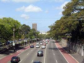 | |
| Parramatta Road, near its eastern end | |
| General information | |
| Type | Road |
| Length | 23 km (14 mi) |
| Opened | 1811 |
| Route number(s) |
|
| Former route number |
|
| Major junctions | |
| East end |
|
| West end |
|
| Location(s) | |
| Major suburbs | Ultimo, Chippendale, Glebe, Camperdown |
| |
Parramatta Road is the major historical east-west artery of metropolitan Sydney, Australia, connecting the Sydney CBD with Parramatta. It is the easternmost part of the Great Western Highway. Much of its traffic has been diverted to modern expressways such as the M4 and the City West Link Road.
The road begins in the east as a continuation of George Street and Broadway and skirts the southern contours of Sydney Harbour and the Parramatta River to Parramatta. On its 23 kilometres (14 mi) long strip, the road is filled with pubs, shops and car yards. Though, at the same time, it has over 100 abandoned and derelict stores.[1][2] Owing to this and its abrasively noisy traffic, it has rarely been considered beautiful.[3]
Opened in 1811, it is one of Sydney's oldest road and Australia's first highway between two cities. Today, over 3 million commuters every year drive Parramatta Road.[4] The road is the hub of Sydney's motor dealership industry - with 67% of the adjacent land use devoted to motor retailing and services.
History
1790s–1800s: Development
Parramatta was settled by Europeans in the same year (1788) as Sydney. The Parramatta River was used as navigation between them. Sometime between 1789 and 1791 an overland track was made to provide an official land route between the two settlements.[5]
Parramatta Road dates to the 1792 formation of a route linking Sydney to the settlement of Parramatta, formalised under the direction of Surveyor-General Augustus Alt in 1797. Parramatta Road became one of the colony's most important early roadways, and for many years remained one of Sydney's premier thoroughfares.[6]
The early track was poorly built and poorly maintained. In 1794, the governor reported that he had caused a very good road to be made, but there is no evidence that any bridges were built over the streams. On 9 June 1805, the Sydney Gazette reported that the road was impassable as the result of heavy rain. Attempts to improve the road continued over the years.
In the 1800s, the completion of several necessary extensions to the road was heavily reliant on the result of a sale between the Sisters of the Good Samaritan, Australia's first religious congregation, and the Government. The Burwood-Ashfield section of the road was previously a part of the Rosebank Estate, on which Rosebank College now stands. They agreed and sold the land to allow construction. The campus of the historic heritage-listed private school is now located adjactent to the road.
1810–1815
By 1811, Parramatta Road had officially open to traffic and was financed during a large portion of the 19th century by a toll, with toll booths located at what now is Sydney University and the Duck River. Governor Macquarie called tenders for the repair of the road raised a 3 shilling per gallon levy on spirits and levied a toll to pay for the work. The road was to be 10 metres wide. This turnpike road was opened on 10 April 1811. The toll barriers were at the present Railway Square and at Becket's Creek (near Parramatta).
In 1814, a stage cart service was established along Parramatta Road. Sydney's oldest road and Australia's first intercity highway, fares were 10 shillings for passengers and 3 pence for letters. Heavy rain again nearly destroyed this road, so in 1817 it was announced that all tree-stumps would be removed and the road paved with stone which would be covered with earth and gravel. This improvement was announced as finished on 15 January 1815.
In 1815 the "profit" from the Sydney toll reached £465. The growth of Sydney caused the toll barrier to be moved to Grose Farm (present University of Sydney) in April 1836. In 1839 it was moved further west to Annandale.[7]
1820s–1880s
The colony's first stage coach (valued at £300) was imported in 1821 but did not begin regular service until 1823. The stage left the city at 7am, arrived in Parramatta at 9:30am and left Parramatta for the return journey at 4pm. Inside passengers were charged 6 shillings. Hazards on the road included aborigines and bushrangers. Hotels and settlements sprang up along the road.[8]
In 1851, Parramatta Road was the scene of heavy traffic as a procession of drays, other vehicles and pedestrians made their way westward to the goldfields of Bathurst.
The importance of the road declined with the advent of the railway in 1855. In 1883, a steam tram line opened to Annandale along Parramatta Road, and was extended to Short Street, Leichhardt via Norton Street in 1884.
1900s–present: Motorisation
This line was electrified in 1901. Thereafter, the Sydney Municipal Council set about widening the major routes into the city. The Sydney end of Parramatta Road (which lies in a cutting) was widened and improved in 1910-1911. The 20th century also saw the advent of motorised traffic on the road.[9]
In the 1920s, the surface of the road was sealed and trams were removed from the road. Sheep and cattle were still crossing Parramatta Road at Homebush as late as the 1960s.
In 2012 it was announced that the road would be widened and lowered below street level in a "slot" as part of the WestConnex highway proposal of the NSW Government. From Parramatta to Penrith, a road along the 2013 alignment of the Great Western Highway (except at Prospect and Penrith) was constructed soon after completion of the Sydney-Parramatta Road.
Criticism
The road has been criticised by Sydneysiders for its traffic pollution, congestion, and for its hundreds of boarded-up shops and rundown buildings that lie on its strip (mainly in the suburbs between Concord and Leichhardt).[10]
A local mayor described it as a "varicose vein".[11] A NSW Business Chamber Executive Patricia Forsythe said that the road is "one of the least attractive commercial areas of Sydney". Former NSW premier Nick Greiner thought the road looked "like Beirut on a bad day". The Herald writer Elizabeth Farrelly dismissed it as a "filthy hole".[12]
On a lighter note, Tess De Quincey, an Australian performer/director said, "Every chapter of Sydney's history has been written on Parramatta Road."[13] A Sydney Morning Herald editor said that whilst the road is "ugly in parts, drab in others, and generally unpleasant", it is still "fundamental to the economic and social viability of the greater city".[14]
Location

The highway forms the boundaries of various suburbs along the way and ends at the junction of Church Street, Parramatta, where the Great Western Highway briefly turns to the north. Parramatta Road forms the southern boundary of the following suburbs:
Parramatta Road forms the northern boundary of the following suburbs:
West of Concord and Burwood, Parramatta Road passes through Strathfield, Homebush, Auburn and Granville before reaching Parramatta.
References
- ↑ "City's main artery a desolate wasteland". The Daily Telegraph, Mason McCann. April 18, 2011. Retrieved 14 January 2015.
- ↑ "AV Union". Time Out Sydney, Nicholas Adams. 16 Oct 2012. Retrieved 14 January 2015.
- ↑ "Renew project targets Forum". Alt Media, Mason McCann. September 26, 2013. Retrieved 14 January 2015.
- ↑ http://www.parramattaroad.com/html/history.html
- ↑ Broomham, Rosemary (2001), Vital connections: a history of NSW roads from 1788, Hale & Iremonger in association with the Roads and Traffic Authority NSW, p. 25, ISBN 978-0-86806-703-2
- ↑ "Sandstone Kerb - Parramatta Road". State Heritage Register. Office of Environment and Heritage, Government of New South Wales. 2005. Retrieved 7 October 2013.
- ↑ Francis Peron, 'Account of Port Jackson and Sydney Town, New South Wales', translation quoted in The literary panorama, vol 10, Charles Taylor, London, 1809, col 921
- ↑ The Roadmakers: A History of Main Roads in New South Wales, Department of Main Roads, Sydney, 1976, p 47
- ↑ The Roadmakers: A History of Main Roads in New South Wales, Department of Main Roads, Sydney, 1976, p 68
- ↑ "CAN PARRAMATTA RD ROCK ONCE MORE?". Ciao Magazine. July 12, 2013. Retrieved 14 January 2015.
- ↑ "200-year dream for renewal and free flow for 'varicose vein'". Sydney Morning Herald. 5 Oct 2012. Retrieved 16 January 2015.
- ↑ "Developers won't save Parramatta Road alone". Elizabeth Farrelly, Sydney Morning Herald. June 21, 2012. Retrieved 16 January 2015.
- ↑ https://books.google.com.au/books?isbn=9052010366
- ↑ "A chance to get Parramatta Road right". Sydney Morning Herald. 31 Oct 2014. Retrieved 16 January 2015.
External links
Coordinates: 33°52′05″S 151°05′57″E / 33.86814°S 151.09909°E