List of scheduled monuments in North Somerset

North Somerset is a unitary authority area in England. Its area covers part of the ceremonial county of Somerset but it is administered independently of the non-metropolitan county. Its administrative headquarters is in the town hall in Weston-super-Mare. North Somerset borders the local government areas of Bristol, Bath and North East Somerset, Mendip and Sedgemoor. North Somerset contains the parliamentary constituencies of Weston-super-Mare and North Somerset.
A scheduled monument is a nationally important archaeological site or monument which is given legal protection by being placed on a list (or "schedule") by the Secretary of State for Culture, Media and Sport; English Heritage takes the leading role in identifying such sites. The legislation governing this is the Ancient Monuments and Archaeological Areas Act 1979. The term "monument" can apply to the whole range of archaeological sites, and they are not always visible above ground. Such sites have to have been deliberately constructed by human activity. They range from prehistoric standing stones and burial sites, through Roman remains and medieval structures such as castles and monasteries, to later structures such as industrial sites and buildings constructed for the World Wars or the Cold War.[1]
There are 68 scheduled monuments in North Somerset. The oldest site Aveline's Hole, a cave in which bones from the Mesolithic have been identified maling it the earliest scientifically dated cemetery in Britain.[2] There are also multiple Neolithic tumuli. There are also several Iron Age hillforts, such as the one at Worlebury Camp. Dolebury Warren, another Iron Age hillfort, was reused as a medieval rabbit warren. The Romano-British period is represented with sites including villas. Sites from the Middle Ages include motte-and-bailey castles, such as Locking Castle, and church crosses. There are also several deserted medieval settlements. Woodspring Priory is a former Augustinian priory founded in the early 13th century.[3] More recent sites date from the Industrial Revolution and include the Elms colliery and glassworks in Nailsea. The most recent monuments are two Palmerstonian gun batteries, built in the 1860s, on the island of Steep Holm.[4] The monuments are listed below using the titles given in the English Heritage data sheets.
Monuments
| Name | Location | Type | Completed [note 1] | Grid ref.[note 2] Geo-coordinates | Notes | Entry number [note 3] | Image | Ref. |
|---|---|---|---|---|---|---|---|---|
| Aveline's Hole, Burrington Combe | Burrington Combe | Cave | Mesolithic | ST 47626 58676 51°19′29″N 2°45′12″W / 51.3247°N 2.7533°W |
Aveline's Hole is a limestone cave in Burrington Combe. The earliest scientifically dated cemetery in Britain was found at Aveline's Hole. The human bone fragments it contained, from over 50 different individuals, are thought to be between roughly 10,200 and 10,400 years old. | 1010297 |  | [2][5][6] |
| Banwell Camp: a large multivallate Hillfort on Banwell Plain | Banwell | Hillfort | Iron Age | ST 40939 59002 51°19′37″N 2°50′56″W / 51.3269°N 2.8489°W |
Banwell Camp is a multivallate Iron Age hillfort. The hillfort is situated approximately 1.6 miles (2.6 km) east from the town of Banwell. Some artefacts found on the site dates back to the Bronze Age and the Stone Age. | 1008031 |  | [7][8] [9][10] |
| Bell barrow 650 m south-west of Uphill Farm | Weston-super-Mare | Bell barrow | Bronze Age | ST 31612 57914 51°18′58″N 2°58′58″W / 51.3162°N 2.9827°W |
A Bell barrow with a diameter of 13 metres (43 ft). | 1011130 | | [11] |
| Bowl barrow 90 m south-west of Bicknell Farm | Nempnett Thrubwell | Bowl barrow | Neolithic to Bronze Age | ST 51641 62732 51°21′41″N 2°41′46″W / 51.3615°N 2.6960°W |
A Bell barrow with a diameter of approximately 26 metres (85 ft). | 1008294 | | [12] |
| Bowl barrow 170 m east of Poplar Farm | Winford | Bowl barrow | Neolithic to Bronze Age | ST 52388 65492 51°23′11″N 2°41′08″W / 51.3865°N 2.6856°W |
A Bell barrow with a diameter of 30 metres (98 ft). | 1008297 | 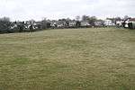 | [13] |
| Bowl barrow 230 m NNE of Quarry Farm: part of the Redhill round barrow cemetery | Wrington | Bowl barrow | Bronze Age | ST 50568 63860 51°22′18″N 2°42′41″W / 51.3716°N 2.7115°W |
A bowl barrow with a diameter of approximately 15 metres (49 ft). It is part of the Redhill round barrow cemetery. | 1011129 | | [14] |
| Bowl barrow 300 m NNE of Quarry Farm: part of the Redhill round barrow cemetery | Wrington | Bowl barrow | Bronze Age | ST 50613 63916 51°22′20″N 2°42′39″W / 51.3721°N 2.7109°W |
A Bowl barrow with a diameter of 12 metres (39 ft). It is part of the Redhill round barrow cemetery. | 1011128 | | [15] |
| Bowl barrow 420 m ENE of Quarry Farm: part of the Redhill round barrow cemetery | Wrington | Bowl barrow | Bronze Age | ST 50831 63833 51°22′17″N 2°42′28″W / 51.3714°N 2.7077°W |
A Bowl barrow with a diameter of 24 metres (79 ft). It is part of the Redhill round barrow cemetery. | 1011126 | | [16] |
| Bowl barrow on Shiplate Slait | Loxton | Bowl barrow | Neolithic to Bronze Age | ST 36558 57052 51°18′32″N 2°54′41″W / 51.3090°N 2.9115°W |
A Bowl barrow with a diameter of 24 metres (79 ft) and around 1.2 metres (3 ft 11 in) high. | 1009883 | | [17] |
| Cadbury Camp, a small multivalate hillfort on Cadbury Hill | Tickenham | Hillfort | Iron Age | ST 45406 72467 51°26′45″N 2°47′12″W / 51.4458°N 2.7867°W |
Cadbury Camp is a well-preserved Iron Age hillfort. It is managed by the National Trust through a Higher Level Stewardship agreement with Natural England which involves tree clearing and management of the scrub. Although primarily known as a fort during the Iron Age it is likely, from artefacts discovered at the site, that it was first used in the Bronze Age and still occupied through the Roman era into the Anglo-Saxon period. | 1008295 |  | [18][19] [20] |
| Chapel at Lower Court | Long Ashton | Chantry chapel | 13th century | ST 54891 70241 51°25′46″N 2°39′01″W / 51.4294°N 2.6502°W |
A disused stone chantry chapel with a tiled roof. | 1007015 | | [21][22] |
| Churchyard cross in St Andrew's churchyard | Backwell | Cross | 15th century | ST 49312 68323 51°24′41″N 2°43′50″W / 51.4114°N 2.7306°W |
A 3-metre (9.8 ft) high stone cross on a stepped base which dates from the 15th century. The lantern head of the cross was added in the 19th century replacing the original stone dial and ball. | 1016202 | .jpg) | [23] |
| Churchyard cross in St Bridget's churchyard, Chelvey | Chelvey, Brockley, Somerset | Cross | 14th century | ST 46619 68355 51°24′43″N 2°46′04″W / 51.4119°N 2.7678°W |
A 1.5-metre (4 ft 11 in) high stone cross on an octagonal stepped base which dates from the 14th century. The box and ball at the top of the shaft was added in 1877. | 1015507 | .jpg) | [24] |
| Churchyard cross in St Andrew's churchyard | Congresbury | Cross | 14th century | ST 43598 63744 51°22′12″N 2°48′42″W / 51.370°N 2.8116°W |
A 14th century stone cross on an octagonal stepped base. | 1015506 |  | [25] |
| Churchyard cross in All Saints churchyard | Kingston Seymour | Cross | 13th century | ST 40098 66846 51°23′51″N 2°51′45″W / 51.3975°N 2.8624°W |
The shaft of the churchyard cross is 1.5 metres (4 ft 11 in) high and stands on an octagonal base. The shaft was added in 1863. | 1015509 | .jpg) | [26] |
| Churchyard cross at St John's Church, Weston-super-Mare | Weston-super-Mare | Cross | 13th century | ST 31792 61933 51°21′09″N 2°58′51″W / 51.3524°N 2.9809°W |
A late 13th century stone cross. The upper part of the shaft is missing. | 1005420 | .jpg) | [27] |
| Churchyard cross in St John The Evangelist's churchyard | Kenn | Cross | 14th century | ST 41606 68969 51°25′00″N 2°50′28″W / 51.4167°N 2.8411°W |
The shaft of the churchyard cross is approximately 2.2 metres (7 ft 3 in) high and stands on a four-step octagonal base. The present cross head was added in 1920. | 1015515 | 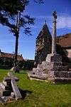 | [28] |
| Churchyard cross in St Mary and St Peter's churchyard | Winford | Cross | 15th century | ST 54293 65005 51°22′57″N 2°39′29″W / 51.3825°N 2.6581°W |
The base of a churchyard cross on a stepped octagonal base. | 1015875 | .jpg) | [29] |
| Churchyard cross in St Michael's churchyard | Dundry | Cross | 15th century | ST 55736 66869 51°23′56″N 2°38′14″W / 51.3990°N 2.6373°W |
The shaft of the churchyard cross is approximately 3 metres (9.8 ft) high and stands on a four-step octagonal base. The cross head was added in the 19th century replacing the original canopied head. | 1015512 | .jpg) | [30] |
| Cross in St Lawrence's churchyard | Wick St. Lawrence | Cross | 1480 | ST 36650 65433 51°23′04″N 2°54′42″W / 51.3844°N 2.9117°W |
The octagonal base of a churchyard cross which was erected around 1480. | 1016198 | | [31] |
| Congresbury village cross | Congresbury | Cross | Middle Ages | ST 43733 63816 51°22′14″N 2°48′35″W / 51.3706°N 2.8097°W |
A 2.5-metre (8 ft 2 in) high 15th century cross on an octagonal plinth. The head of the cross was replaced in the early 19th century. | 1015505 |  | [32] |
| Deserted medieval farmstead 420 m south of Gout House Farm | Banwell | Earthworks | Middle Ages | ST 40215 61071 51°20′44″N 2°51′35″W / 51.3456°N 2.8598°W |
Earthworks from farm buildings occupied from the 11th to 14th centuries; however archaeological remains suggest the site was first occupied in the Romano-British period. The raised area which was occupied by the Bower House was surrounded by a water filled ditch, part of which has since been incorporated into a rhyne. | 1011133 | | [33] |
| Deserted medieval farmstead and part of a Romano-British field system 400 m north of Fenswood Farm | Long Ashton | Earthworks | Middle Ages | ST 53285 70470 51°25′53″N 2°40′24″W / 51.4313°N 2.6734°W |
Three enclosures which are thought to be the foundations of buildings, each surrounded by a rubble banks. | 1011979 | | [34] |
| Deserted medieval settlement 300 m ESE of Wraxall House | Wraxall | Earthworks | Middle Ages | ST 48755 71368 51°26′20″N 2°44′19″W / 51.4390°N 2.7387°W |
Earthworks from houses, enclosures and possibly a watermill which were occupied in the Middle Ages. | 1011259 | | [35] |
| Dolebury Camp: a large univallate hillfort and associated and later earthworks on Dolebury Warren | Churchill | Hillfort | Iron Age and post Medieval | ST 45120 58958 51°19′39″N 2°47′01″W / 51.3275°N 2.7836°W |
Dolebury Warren is a 90.6 hectares (224 acres) biological Site of Special Scientific Interest (SSSI) and ancient monument. It is owned by the National Trust, who acquired the freehold in 1983, and managed by the Avon Wildlife Trust. Standing on a limestone ridge on the northern edge of the Mendip Hills, it was made into a hillfort during the Iron Age and was occupied into the Roman period. The extensive fort covers 9.1 hectares (22 acres) with single or double defensive ramparts around it. The name Dolebury Warren comes from its use during the medieval or post medieval periods as a rabbit warren. The topography and differing soil types provide a habitat for an unusually wide range of plants, attracting a variety of insects including butterflies. | 1008184 |  | [36][37] [38] |
| Duck decoy, 250 m south of Black Rock Villas | Weston-in-Gordano | Duck decoy | 18th century | ST 45672 74247 51°27′53″N 2°47′00″W / 51.4646°N 2.7834°W |
Earthworks of an 18th century six pipe duck decoy. | 1015949 | | [39] |
| Elms Colliery | Nailsea | Coal mine | 18th century | ST 48218 70558 51°25′54″N 2°44′47″W / 51.4316°N 2.7463°W |
Three buildings survive from the Elms Colliery, also known as Middle Engine Pit, which operated from the late 18th century until closure in the 1850s. The site has been placed on the Heritage at Risk register. | 1004533 | .jpg) | [40][41] [42] |
| Iron Age defended settlement 400 m south of Manor Farm | Wraxall | Earthworks | Iron Age | ST 52051 71927 51°26′39″N 2°41′29″W / 51.4443°N 2.6913°W |
Earthworks of an oval defended settlement surrounded by a bank and ditch. | 1018267 | | [43] |
| Large univallate hillfort on Cadbury Hill | Congresbury | Hillfort | Iron Age | ST 44153 64950 51°22′49″N 2°48′12″W / 51.3804°N 2.8032°W |
Cadbury Hill hillfort is known, in archaeological circles, as Cadbury-Congresbury in order to differentiate it from the Cadbury Castle hillfort in South Cadbury. It appears to have been constructed in the Iron Age when one or more ramparts, with walls and ditches, were built on the steep slopes of the hill to defend an area covering some 8.5 acres (3.4 ha). The remains of Iron Age round houses may still be seen inside. The hillfort was refortified between 430 and 480 AD and occupation extended into the sub-Roman period, from which much imported pottery has been recovered. | 1011258 |  | [44][45] |
| Littleton gunpowder works at Powdermill Farm | Winford | Powder mill | c. 1650 | ST 54981 64406 51°22′37″N 2°38′54″W / 51.3769°N 2.6482°W |
Littleton gunpowder works opened around 1650 and expanded to become the largest powder producing works in South West England by the middle of the 18th century. It closed in the 1820s after the end of the Napoleonic Wars. Some of the buildings remain intact, while others are ruined. | 1019452 |  | [46] |
| Long barrow on Redhill | Wrington | Long barrow | Neolithic | ST 49956 63603 51°22′09″N 2°43′13″W / 51.3693°N 2.7203°W |
A long barrow which is approximately 53 metres (174 ft) long, 11 metres (36 ft) wide and 0.6 metres (2 ft 0 in) high. | 1008289 | | [47] |
| Long barrow 350 m south-west of Cornerpool Farm | Wrington | Long barrow | Neolithic | ST 50057 64386 51°22′35″N 2°43′08″W / 51.3763°N 2.7189°W |
A collapsed chambered long barrow. The fallen portal stone and three supporting stones are still visible. | 1008291 |  | [48] |
| Moated site at Nye Farm | Winscombe | Earthworks | Middle Ages | ST 41376 61536 51°21′00″N 2°50′36″W / 51.3499°N 2.8432°W |
An area of raised ground surrounded by a 10-metre (33 ft) wide moat. It is known to have been occupied of the site is recorded in 1290 and 1332. | 1011132 | .jpg) | [49] |
| Manorial settlement at Weston Manor | Weston-in-Gordano | Earthworks | Middle Ages | ST 44461 74019 51°27′45″N 2°48′03″W / 51.4624°N 2.8008°W |
The remains of a manor house constructed around 1430, damaged in the English Civil War and occupied until 1692. Some of the masonry from the house has been used as part of a boundary wall. | 1007913 | | [50] |
| Minor Romano-British villa 650 m north-east of Hewish Farm | Yatton | Roman villa | Romano-British | ST 40509 65243 51°22′59″N 2°51′22″W / 51.3831°N 2.8562°W |
The site of a Romano-British villa with mosaic floors and hypocausts. Coins and pottery from 250 to 360 AD have been discovered at the site. Some of the walls can still be identified as low grass covered banks. | 1011262 | | [51] |
| Motte-and-bailey castle and associated earthworks south of Locking Head Farm | Locking | Motte-and-bailey castle | 12th century | ST 36373 60881 51°20′36″N 2°54′54″W / 51.3434°N 2.9149°W |
Locking Castle was a motte-and-bailey on Carberry Hill. Excavations in 1902 identified the remains of a small stone chamber surrounded by a ditch. Fragments of pottery and the remains of a sword were also found. The origin of the castle is unclear. It may have been part of the manor of Kewstoke or alternatively Hutton. The two manors were combined and given by Henry I to Geoffrey de Dun. In 1214 Locking was given to Woodspring Priory and would have ceased to have military significance. | 1008301 |  | [52][53] [54] |
| Motte-and-bailey castle 650 m NNW of Sandpoint Farm | Kewstoke | Motte-and-bailey castle | Middle Ages | ST 32641 66044 51°23′22″N 2°58′10″W / 51.3894°N 2.9694°W |
A motte-and-bailey castle was constructed on Sand Point and Middle Hope after the Norman Conquest. | 1008114 | | [55][56] |
| Motte at Castle Batch | Worle | Motte-and-bailey castle | Middle Ages | ST 36172 63707 51°22′08″N 2°55′06″W / 51.3688°N 2.9182°W |
Castle Batch was a motte constructed by the Norman lord Walter of Douai between the Norman conquest of England in 1066 and 1086. It was built on a ridge above the surrounding area, with a mound that is now 3 metres (9.8 ft) high and 42 metres (138 ft) across, surrounded by a ditch up to 10 metres (33 ft) wide. The entrance was probably on the north side of the motte. A possible bailey has been identified alongside the motte. Although typically characterised as a motte, the mound has a slight indentation in the centre and historian Stuart Prior considers the mound to have been a ringwork. | 1011131 |  | [57] [58] |
| Nailsea Glassworks | Nailsea | Glassworks | 1790 | ST 47677 70843 51°26′03″N 2°45′15″W / 51.4342°N 2.7541°W |
The remaining site and buildings of a glassworks which operated from 1788 until 1874. The visible remains include parts of kilns and ancillary buildings. The site was excavated in 1983 as part of the construction of a new ring road over part of the site. | 1021462 | .jpg) | [59][60] [61] |
| Oval barrow on Felton Hill 100 m east of The Round House | Winford | Oval barrow | Neolithic | ST 51624 64906 51°22′52″N 2°41′47″W / 51.3811°N 2.6965°W |
An oval barrow which is approximately 1 metre (3 ft 3 in) high, 16 metres (52 ft) long and 20 metres (66 ft) wide. | 1008300 | | [62] |
| Parts of a minor Romano-British villa and later medieval barn 545 m south east of St Mary's Well | Portishead and North Weston | Roman villa | Romano-British | ST 46604 75456 51°28′32″N 2°46′13″W / 51.4755°N 2.7702°W |
The buried remains of a Roman villa which had a barn built over it between the 13th and 15th centuries. | 1007001 | | [63] |
| Roman small town, part of an associated field system and earlier Iron Age settlement remains at Gatcombe, 250 m north of Cambridge Batch | Long Ashton | Earthworks | Iron Age and Romano-British | ST 52691 69975 51°25′32″N 2°40′56″W / 51.4256°N 2.6822°W |
This was an Iron Age settlement Romanised in the late first century. It grew to become a commercial agricultural centre which was abandoned by about 200 AD. Around 300 AD a defensive wall was constructed up to 5 metres (16 ft) thick enclosing an area of about 7 hectares (17 acres). Remains include both a mosaic pavement and evidence of industrial activities, and coins shows that the site was occupied throughout the Roman period. The site may have been finally abandoned during an outbreak of bubonic plague in the middle of the sixth century. | 1011978 | | [64][65] |
| Romano-British villa, Banwell | Banwell | Roman villa | Romano-British | ST 39822 59315 51°19′47″N 2°51′54″W / 51.3297°N 2.8651°W |
Building platforms from a Roman villa, which included a bath house, with a mosaic floor over a hypocaust, a courtyard and other buildings. | 1013434 | | [66] |
| Shrunken medieval village of Christon and associated field system 200 m north of Manor Farm | Loxton | Earthworks | Middle Ages | ST 37690 57574 51°18′50″N 2°53′43″W / 51.3138°N 2.8954°W |
Earthworks for a deserted village which covered around 2.5 hectares (6.2 acres). A surrounding field system includes strip lynchets. | 1008186 | | [67] |
| Slight univallate hillfort and associated earthworks on Burrington Ham | Burrington | Hillfort | Iron Age | ST 47803 58789 51°19′28″N 2°44′22″W / 51.3244°N 2.7394°W |
Burrington Camp, also known as Burrington Ham, is an Iron Age hillfort situated in the Mendip Hills approximately 0.6 miles (0.97 km) south from the village of Burrington. The camp overlooks Burrington Combe, where there have been archaeological discoveries of cemeteries, demonstrating a very long human occupation of the area. The hillfort has an oval shape and is univallate. | 1011261 |  | [68][69] |
| Slight univallate hillfort 150 m east of Cleeve Court | Cleeve | Hillfort | Late Bronze Age or Iron Age | ST 46257 65691 51°23′16″N 2°46′25″W / 51.3877°N 2.7737°W |
An oval hillfort approximately 125 metres (410 ft) from east to west and 90 metres (300 ft) from north to south, surrounded by a bank and ditch. | 1011263 | | [70] |
| Slight univallate hillfort 115 m east of Brockley Cottage | Brockley | Hillfort | Iron Age | ST 47789 67096 51°23′59″N 2°44′56″W / 51.3997°N 2.7489°W |
Taps Combe Camp (also known as Chelvey Batch Settlement) is an Iron Age hillfort situated approximately 1.8 miles (2.9 km) east from the village of Brockley. The hillfort is shaped like a "D", and is approximately 50 metres (160 ft) by 50 metres (160 ft) wide. | 1007909 | | [71][72] |
| Slight univallate hillfort at Wain's Hill | Clevedon | Hillfort | Iron Age | ST 39085 70655 51°25′54″N 2°52′41″W / 51.4317°N 2.8781°W |
Wain's Hill is an univallate Iron Age hillfort. The hillfort is defined by a steep, natural slope from the south and north with two ramparts to the east. | 1007908 |  | [73] |
| Slight univallate hillfort on Conygar Hill | Portbury | Hillfort | Iron Age | ST 49896 75094 51°28′21″N 2°43′22″W / 51.4726°N 2.7228°W |
Conygar Hillfort is a small multivallate Iron Age hillfort. The fort is triangular in shape and there are the remains of a 3 feet (0.91 m) high bank on the south-western side. | 1007918 | | [74] |
| Slight univallate hillfort, two avenues, saucer barrow, regular aggregate field system and associated earthworks on Walton Common | Walton Common | Hillfort | Bronze Age and Iron Age | ST 43027 73868 51°27′39″N 2°49′17″W / 51.4609°N 2.8215°W |
Earthworks form a hillfort surrounded by a bank and ditch and associated saucer shaped round barrow and field system. | 1007917 | | [75] |
| Slight univallate hillfort and associated settlement remains 300 m north-east of Cleeve Court | Cleeve | Hillfort | Late Bronze Age or Iron Age | ST 46298 65908 51°23′23″N 2°46′24″W / 51.3896°N 2.7732°W |
A sloping oval hillfort which is 50 metres (160 ft) from east to west and 45 metres (148 ft) from north to south, surrounded by a bank and ditch. | 1011264 | | [76] |
| Stokeleigh Camp: a promontory fort in Leigh Woods | Leigh Woods | Hillfort | Iron Age | ST 55901 73331 51°27′25″N 2°38′15″W / 51.4569°N 2.6375°W |
Stokeleigh Camp is one of three Iron Age fortifications overlooking the Avon Gorge, the others being Burwalls south of the Nightingale Valley, of which almost no trace remains, and the other being Clifton Camp on the opposite side of the gorge, on Clifton Down near the Observatory. Stokeleigh Camp is situated on a promontory, and occupies around 3.0 hectares (7.5 acres). | 1008113 |  | [77][78][79] [80][81] |
| The Fairy Toot long barrow 350 m SSW of Howgrove Farm | Nempnett Thrubwell | Long barrow | Neolithic | ST 52056 61808 51°21′11″N 2°41′24″W / 51.3531°N 2.6899°W |
The Fairy Toot is an extensive oval barrow. It is an example of the Severn-Cotswold tomb type which consist of precisely-built, long trapezoid earth mounds covering a burial chamber. Because of this they are a type of chambered long barrow. The Fairy Toot south-southwest of Howgrove Farm is a mound 60 m long, 25 m wide and now 2.5 m high, retained by a stone wall. Its summit is covered with ash trees and shrubs. Formerly it was considerably higher. On being opened and essentially destroyed between 1787 and 1835 it was found to contain two rows of cells, running from south to north, formed by immense stones set edgeways, and covered by others of larger dimensions. A human skull from the barrow is now in the Bristol Museum and Art Gallery. | 1008181 | | [82][83] |
| Two bowl barrows 400 m north-east of Quarry Farm: part of the Redhill round barrow cemetery | Wrington | Bowl barrow | Bronze Age | ST 50747 63897 51°22′19″N 2°42′32″W / 51.3720°N 2.7090°W |
Two bowl barrows, one 15 metres (49 ft) wide and the other 25 metres (82 ft). | 1011127 | | [84] |
| Two bowl barrows on Shiplate Slait | Loxton | Bowl barrows | Neolithic to Bronze Age | ST 36581 57090 51°18′34″N 2°54′40″W / 51.3094°N 2.9112°W |
Two bowl barrows, one 8 metres (26 ft) wide and the other 7 metres (23 ft). | 1008112 | | [85] |
| Two confluent bowl barrows on Felton Hill | Winford | Bowl barrow | Neolithic to Bronze Age | ST 51958 64820 51°22′49″N 2°41′30″W / 51.3804°N 2.6917°W |
Two confluent bowl barrows, one 22 metres (72 ft) in diameter and the other 21 metres (69 ft). | 1008361 | | [86] |
| Two Palmerstonian gun batteries on Steep Holm | Steep Holm | Palmerston Fort | 1860s | ST 22488 60683 51°20′24″N 3°06′51″W / 51.3399°N 3.1142°W |
Steep Holm is an English island lying in the Bristol Channel. It formed part of a line of defences, known as Palmerston Forts, built across the channel to protect the approaches to Bristol and Cardiff. Construction began in 1865 and was completed in 1869. These facilities were updated in both World War I and World War II. | 1005415 |  | [4] |
| Wick St. Lawrence village cross | Wick St Lawrence | Cross | 15th century | ST 36605 65388 51°23′02″N 2°54′45″W / 51.3840°N 2.9124°W |
A 15th century village cross standing on an area of grass opposite the parish church, raised up on five ascending octagonal stone platforms. | 1015513 | 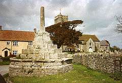 | [87] |
| Woodspring Priory and associated fishponds and field system | Kewstoke | Priory | 15th century | ST 34292 66105 51°23′27″N 2°56′42″W / 51.3908°N 2.9450°W |
Woodspring Priory is a former Augustinian priory. The priory was founded, by William de Courtney, in the early 13th century. It was dissolved in 1536 and then owned by local noblemen and leased to local farmers. In 1968 the priory and adjoining land of Middle Hope was purchased by the National Trust as part of Project Neptune. The following year the priory was taken over by the Landmark Trust who spent 20 years on restoration work, and now rent out the farmhouse as holiday accommodation. The surviving buildings include the priory church, which was a 15th century replacement for the earlier 13th century structure, infirmary, barn and 16th century prior's lodging which was converted into a farmhouse. The whole site was arranged around a central cloister from which only the east wall and west wall of the chapter house remain, the sacristy, refectory, chapter house, lady chapel and parlour having been demolished. | 1012722 |  | [88][89] |
| Worlebury Camp: a large multivallate hillfort on Worlebury Hill | Weston-super-Mare | Hillfort | Iron Age | ST 31282 62493 51°21′27″N 2°59′07″W / 51.3574°N 2.9852°W |
Worlebury Camp is an Iron Age hillfort once stood atop Worlebury Hill. This fort was designed for defence, as is evidenced the number of walls and ditches around the site. Archaeologists have found several large triangular platforms around the sides of the fort, lower down on the hillside. They have found nearly one hundred storage pits of various sizes cut into the bedrock, and many of these had human remains, coins, and other artefacts in them. | 1011260 |  | [90][91] [92][93] |
See also
- Scheduled Monuments in Somerset
- Grade I listed buildings in North Somerset
- Grade II* listed buildings in North Somerset
Notes
- ↑ The date given is the date used by Historic England as significant for the initial building or that of an important part in the structure's description.
- ↑ Sometimes known as OSGB36, the grid reference is based on the British national grid reference system used by the Ordnance Survey.
- ↑ The "List Entry Number" is a unique number assigned to each listed building and scheduled monument by Historic England.
References
- ↑ "Scheduled Monuments". English Heritage. Retrieved 9 September 2014.
- 1 2 "Earliest British cemetery dated". BBC. 23 September 2003. Retrieved 5 January 2010.
- ↑ William Page (editor) (1911). "Houses of Augustinian canons: The priory of Worspring". A History of the County of Somerset: Volume 2. Institute of Historical Research. Retrieved 15 October 2015.
- 1 2 Worrall, D. H.; Surtees, P. R. (1984). "Flat Holm – an account of its history and ecology". South Glamorgan County Council: 18–19.
- ↑ Witcombe, Richard (2009). Who was Aveline anyway?: Mendip's Cave Names Explained (2nd ed.). Priddy: Wessex Cave Club. pp. 10–11. ISBN 978-0-9500433-6-4.
- ↑ Cunliffe, Barry (2012). Britain Begins. Oxford, UK: Oxford University Press. p. 125. ISBN 978-0-19-960933-8.
- ↑ "Archaeological Aerial Survey in the Northern Mendip Hills: A Highlight Report for the National Mapping Programme" (PDF). English Heritage. p. 32. Retrieved 29 January 2011.
- ↑ "Banwell Camp". Pastscape. English Heritage. Retrieved 29 January 2011.
- ↑ "Mendip Hills". English Heritage. Retrieved 15 January 2011.
- ↑ "Mendip Hills". English Heritage. Retrieved 29 January 2011.
- ↑ "Bell barrow 650 m south-west of Uphill Farm". National Heritage List for England. English Heritage. Retrieved 6 December 2014.
- ↑ "Bowl barrow 90 m south-west of Bicknell Farm". National Heritage List for England. English Heritage. Retrieved 6 December 2014.
- ↑ "Bowl barrow 170 m east of Poplar Farm". National Heritage List for England. English Heritage. Retrieved 6 December 2014.
- ↑ "Bowl barrow 230 m NNE of Quarry Farm: part of the Redhill round barrow cemetery". National Heritage List for England. English Heritage. Retrieved 6 December 2014.
- ↑ "Bowl barrow 300 m NNE of Quarry Farm: part of the Redhill round barrow cemetery". National Heritage List for England. English Heritage. Retrieved 6 December 2014.
- ↑ "Bowl barrow 420 m ENE of Quarry Farm: part of the Redhill round barrow cemetery". National Heritage List for England. English Heritage. Retrieved 6 December 2014.
- ↑ "Bowl barrow on Shiplate Slait". National Heritage List for England. English Heritage. Retrieved 7 December 2014.
- ↑ "Cadbury Camp". National Monument Record. English Heritage. Retrieved 21 December 2013.
- ↑ "Cadbury Camp, a small multivalate hillfort on Cadbury Hill". National Heritage List for England. English Heritage. Retrieved 21 December 2013.
- ↑ "The Iron Age past of Cadbury Camp". National Trust. Retrieved 21 December 2013.
- ↑ "Long Ashton". Bath and Avon Family History Society. Retrieved 16 September 2014.
- ↑ "Chapel, Immediately South of Lower Court Farmhouse". National Heritage List for England. English Heritage. Retrieved 7 December 2014.
- ↑ "Churchyard cross in St Andrew's churchyard". National Heritage List for England. English Heritage. Retrieved 7 December 2014.
- ↑ "Churchyard cross in St Bridget's churchyard, Chelvey". National Heritage List for England. English Heritage. Retrieved 21 August 2014.
- ↑ "Churchyard cross in St Andrew's churchyard". National Heritage List for England. English Heritage. Retrieved 21 August 2014.
- ↑ "Churchyard cross in All Saints churchyard". National Heritage List for England. English Heritage. Retrieved 21 August 2014.
- ↑ "Monument No. 192733". Pastscape. English Heritage. Retrieved 7 December 2014.
- ↑ "Churchyard cross in St John The Evangelist's churchyard". National Heritage List for England. English Heritage. Retrieved 7 December 2014.
- ↑ "Churchyard cross in St Mary and St Peter's churchyard". National Heritage List for England. English Heritage. Retrieved 7 December 2014.
- ↑ "Churchyard cross in St Michael's churchyard". National Heritage List for England. English Heritage. Retrieved 22 August 2014.
- ↑ "Cross in St Lawrence's churchyard". National Heritage List for England. English Heritage. Retrieved 7 December 2014.
- ↑ "Congresbury village cross". National Heritage List for England. English Heritage. Retrieved 7 December 2014.
- ↑ "Deserted medieval farmstead 420 m south of Gout House Farm". National Heritage List for England. English Heritage. Retrieved 7 December 2014.
- ↑ "Deserted medieval farmstead and part of a Romano-British field system 400 m north of Fenswood Farm". National Heritage List for England. English Heritage. Retrieved 7 December 2014.
- ↑ "Deserted medieval settlement 300 m ESE of Wraxall House". National Heritage List for England. English Heritage. Retrieved 7 December 2014.
- ↑ "Acquisitions Up to December 2011" (PDF). National Trust. Retrieved 4 January 2015.
- ↑ "Mendip Hills. Things to see and do". National Trust. Retrieved 21 December 2013.
- ↑ "Dolebury Camp: a large univallate hillfort and associated and later earthworks on Dolebury Warren". National Heritage List for England. English Heritage. Retrieved 22 August 2014.
- ↑ "Duck decoy, 250 m south of Black Rock Villas". National Heritage List for England. English Heritage. Retrieved 7 December 2014.
- ↑ "Middle Engine Pit, Nailsea". Avon Industrial Buildings Trust. Retrieved 21 August 2014.
- ↑ "Heritage at Risk". Bristol Post. 11 July 2008. Retrieved 21 August 2014.
- ↑ "Elms Colliery, Nailsea - North Somerset (UA)". Heritage at Risk. English Heritage. Retrieved 28 October 2015.
- ↑ "Iron Age defended settlement 400 m south of Manor Farm". National Heritage List for England. English Heritage. Retrieved 7 December 2014.
- ↑ "Cadbury Hill Camp". National Monuments Record. English Heritage. Retrieved 22 March 2011.
- ↑ Rahtz, P (1992). Cadbury Congresbury 1968-73: a late Roman/Post-Roman Hilltop settlement in Somerset. BAR/BS 223
- ↑ "Littleton gunpowder works at Powdermill Farm". National Heritage List for England. English Heritage. Retrieved 7 December 2014.
- ↑ "Long barrow on Redhill". National Heritage List for England. English Heritage. Retrieved 7 December 2014.
- ↑ "Long barrow 350 m south-west of Cornerpool Farm". National Heritage List for England. English Heritage. Retrieved 7 December 2014.
- ↑ "Moated site at Nye Farm". National Heritage List for England. English Heritage. Retrieved 7 December 2014.
- ↑ "Manorial settlement at Weston Manor". National Heritage List for England. English Heritage. Retrieved 7 December 2014.
- ↑ "Minor Romano-British villa 650 m north-east of Hewish Farm". National Heritage List for England. English Heritage. Retrieved 7 December 2014.
- ↑ "Locking Castle". English Heritage. Retrieved 23 July 2011.
- ↑ "Locking Castle". Pastscape National Monument Record. English Heritage. Retrieved 22 July 2011.
- ↑ Dunning, Robert (1995). Somerset Castles. Tiverton: Somerset Books. pp. 39–40. ISBN 978-0-86183-278-1.
- ↑ "Motte and bailey castle 650 m NNW of Sandpoint Farm". National Heritage List for England. English Heritage. Retrieved 16 September 2014.
- ↑ "Castle Batch, Kewstoke". Gatehouse. Retrieved 8 January 2015.
- ↑ Prior, Stuart (2006). The Norman Art of War: a Few Well-Positioned Castles. Stroud, UK: Tempus. p. 71. ISBN 0752436511.
- ↑ "YCCCART 2011 / Y9: North Somerset HER 2011/205, Castle Batch, Worle" (PDF). Yatton, Congresbury, Claverham and Cleeve Archaeological Research Team. Retrieved 9 January 2013.
- ↑ "Nailsea Glass". Nailsea Parish Family History and OPC Page. Retrieved 1 July 2010.
- ↑ Smith, Andrew F. (2004). "The Nailsea Glassworks, Nailsea, North Somerset A Study of the History, Archaeology, Technology and the Human Story". Archaeology Data Service (ADS). Retrieved 1 July 2010.
- ↑ "Nailsea Glassworks". National Heritage List for England. English Heritage. Retrieved 10 December 2014.
- ↑ "Oval barrow on Felton Hill 100 m east of The Round House". National Heritage List for England. English Heritage. Retrieved 10 December 2014.
- ↑ "Parts of a minor Romano-British villa and later medieval barn 545 m south east of St Mary's Well". National Heritage List for England. English Heritage. Retrieved 10 December 2014.
- ↑ "Gatcombe Settlement". National Monuments Record. English Heritage. Retrieved 30 April 2011.
- ↑ Smisson; The Gatcombe Environs Research Team, RPM. "Extract from Gatcombe Roman Settlement Geophysical Surveys 2009/2010 Second Progress Report North of the Railway" (PDF). Yatton, Congresbury, Claverham and Cleeve Archaeological Research Team. Retrieved 5 January 2015.
- ↑ "Romano-British villa, Banwell". National Heritage List for England. English Heritage. Retrieved 21 August 2014.
- ↑ "Shrunken medieval village of Christon and associated field system 200 m north of Manor Farm". National Heritage List for England. English Heritage. Retrieved 10 December 2014.
- ↑ "Burrington Camp". National Monuments Record. English Heritage. Retrieved 16 March 2011.
- ↑ "Mendip Hills An Archaeological Survey of the Area of Outstanding Natural Beauty" (PDF). Somerset County Council Archaeological Projects. Retrieved 16 January 2011.
- ↑ "Slight univallate hillfort 150 m east of Cleeve Court". National Heritage List for England. English Heritage. Retrieved 3 January 2015.
- ↑ Everden, Shirley (August 2009). "Enclosure At Chelvey Batch, Broadfield Down Earthwork Survey" (PDF). Retrieved 4 January 2015.
- ↑ Russet, Vince, ed. (2007). "Four Enclosures on Broadfield Down, North Somerset" (PDF). Yatton, Congresbury, Claverham, and Cleeve Archaeological Research Team. YCCCART: 4. Retrieved 4 January 2015.
- ↑ "Wain's hillfort". National Monuments Record. English Heritage. Retrieved 6 March 2011.
- ↑ "Conygar". National Monuments Record. English Heritage. Retrieved 6 March 2011.
- ↑ "Slight univallate hillfort, two avenues, saucer barrow, regular aggregate field system and associated earthworks on Walton Common". National Heritage List for England. English Heritage. Retrieved 3 January 2015.
- ↑ "Slight univallate hillfort and associated settlement remains 300 m north-east of Cleeve Court". National Heritage List for England. English Heritage. Retrieved 3 January 2015.
- ↑ "Stokeleigh Camp Hillfort". Hillfort in England in Somerset. Megalithic Portal. Retrieved 26 December 2010.
- ↑ "Stokeleigh Camp". Roman-Britain.org. Retrieved 29 January 2011.
- ↑ Haldane, J.W. (1966). "Stokeleigh Camp, Somerset" (PDF). Proceedings of the University of Bristol Spelæological Society. Bristol: University of Bristol Spelæological Society. 11 (1): 31–19. Retrieved 30 January 2011.
- ↑ "Stokeleigh Camp". English Heritage. Retrieved 30 January 2011.
- ↑ "Where I Live: Bristol". BBC. October 2004. Retrieved 26 December 2010.
- ↑ "Fairy Toot". National Monuments Record. English Heritage. Retrieved 2 April 2011.
- ↑ Dunn, Richard (2004). Nempnett Thrubwell:Barrows, Names and Manors. Nempnett Books. pp. 33–62. ISBN 0-9548614-0-X.
- ↑ "Two bowl barrows 400 m north-east of Quarry Farm: part of the Redhill round barrow cemetery". National Heritage List for England. English Heritage. Retrieved 3 January 2015.
- ↑ "Two bowl barrows on Shiplate Slait". National Heritage List for England. English Heritage. Retrieved 3 January 2015.
- ↑ "Two confluent bowl barrows on Felton Hill". National Heritage List for England. English Heritage. Retrieved 3 January 2015.
- ↑ "Village cross". Images of England. English Heritage. Retrieved 18 January 2010.
- ↑ Russett, Vince. "Gradiometry & Resistivity Surveys at Woodspring Priory" (PDF). Yatton, Congresbury, Claverham and Cleeve Archaeological Research Team. Retrieved 15 July 2014.
- ↑ "Church of the Blessed Virgin Mary". Images of England. Retrieved 19 October 2007.
- ↑ "Worlebury Camp". Roman-Britain.org. Retrieved 5 October 2010.
- ↑ "Desk-Based Assessment of Land Adjacent to Numbers 2–10 Upper Kewstoke Road, Weston-Super-Mare, North Somerset" (PDF). Project: PJ 195. Mercian Archaeology. Retrieved 16 October 2010.
- ↑ "Advice on Potential Landscape/Seascape and Visual Impacts of a Severn Barrage" (PDF). Land Use Consultants. Retrieved 4 January 2015.
- ↑ "Weston woods LNR". Natural England. Retrieved 4 January 2015.