Lime City, Ohio
| Lime City, Ohio | |
|---|---|
| Unincorporated community | |
 Lime City, Ohio | |
| Coordinates: 41°32′07.3062″N 83°34′03.4716″W / 41.535362833°N 83.567631000°WCoordinates: 41°32′07.3062″N 83°34′03.4716″W / 41.535362833°N 83.567631000°W | |
| Country | United States |
| State | Ohio |
| County | Wood |
| Elevation | 646 ft (197 m) |
| Time zone | Eastern (EST) (UTC-5) |
| • Summer (DST) | EDT (UTC-4) |
| Area code(s) | 419 & 567 |
Lime City is an unincorporated community in Wood County, Ohio, United States.[1] It is part of Perrysburg Township and located at the intersection of Lime City Road and U.S. Route 20 (Fremont Pike). Lacking a post office, Lime City's zip code falls within Perrysburg's 43551.[2]
History
Lime City was platted in 1887, and named for the local lime industry.[3] A post office was in operation at Lime City between 1874 and 1953.[4]
Education
Lime City is part of the Rossford Exempted Village School District and used to have Lime City Elementary as part of the district.[5][6][7][8] Lime City Elementary was a "sister" school to Glenwood Elementary, which is where students from the area currently attend grades K-6.[9]
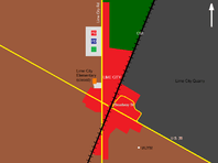
General vicinity of Lime City, Ohio.
Notes
- ↑ http://ohio.hometownlocator.com/oh/wood/lime-city.cfm
- ↑ https://www.google.com/search?q=43551+zip+code+map&oq=43551+zip+code+map&aqs=chrome.0.57j62.3199j0&sourceid=chrome&ie=UTF-8
- ↑ Leeson, Michael A. (1897). Commemorative Historical and Biographical Record of Wood County, Ohio: Its Past and Present, Early Settlement and Development. J.H. Beers & Company. pp. 364–365.
- ↑ "Wood County". Jim Forte Postal History. Retrieved 12 January 2016.
- ↑ Braatz, George (August 11, 1967). "Wood County Watching School Districts Vanish". Toledo Blade. Retrieved February 7, 2013.
- ↑ "Rossford Schools Study Elimination Of 20 Jobs". Toledo Blade. March 23, 1982. Retrieved February 7, 2013.
- ↑ "Students To Go To New Schools". Toledo Blade. August 24, 1982. Retrieved May 10, 2013.
- ↑ "Meeting Called On Revision Of School Districts". Toledo Blade. February 12, 1985. Retrieved May 10, 2013.
- ↑ "Schools Feeling Pinch Of Crowded Classrooms". Toledo Blade. October 18, 1977. Retrieved May 10, 2013.
Municipalities and communities of Wood County, Ohio, United States | ||
|---|---|---|
| Cities |  | |
| Villages | ||
| Townships | ||
| CDPs | ||
| Other unincorporated communities | ||
| Footnotes | ‡This populated place also has portions in an adjacent county or counties | |
This article is issued from Wikipedia - version of the 9/21/2016. The text is available under the Creative Commons Attribution/Share Alike but additional terms may apply for the media files.