Lawrence Township, Cumberland County, New Jersey
- Not to be confused with Lawrence Township, Mercer County.
| Lawrence Township, New Jersey | |
|---|---|
| Township | |
| Township of Lawrence | |
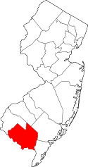
 Lawrence Township highlighted in Cumberland County. Inset map: Cumberland County highlighted in the State of New Jersey. | |
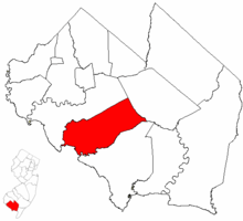
 Census Bureau map of Lawrence Township, Cumberland County, New Jersey | |
| Coordinates: 39°20′06″N 75°11′04″W / 39.334878°N 75.184579°WCoordinates: 39°20′06″N 75°11′04″W / 39.334878°N 75.184579°W[1][2] | |
| Country |
|
| State |
|
| County | Cumberland |
| Incorporated | February 17, 1885 |
| Named for | Capt. James Lawrence |
| Government[3] | |
| • Type | Township |
| • Body | Township Committee |
| • Mayor | Joseph A. Miletta, Jr. (D, term ends December 31, 2016)[4][5] |
| • Clerk | Ruth A. Dawson[6] |
| Area[1] | |
| • Total | 38.332 sq mi (99.279 km2) |
| • Land | 36.917 sq mi (95.614 km2) |
| • Water | 1.415 sq mi (3.665 km2) 3.69% |
| Area rank |
60th of 566 in state 6th of 14 in county[1] |
| Elevation[7] | 39 ft (12 m) |
| Population (2010 Census)[8][9][10] | |
| • Total | 3,290 |
| • Estimate (2015)[11] | 3,227 |
| • Rank |
439th of 566 in state 9th of 14 in county[12] |
| • Density | 89.1/sq mi (34.4/km2) |
| • Density rank |
546th of 566 in state 10th of 14 in county[12] |
| Time zone | Eastern (EST) (UTC-5) |
| • Summer (DST) | Eastern (EDT) (UTC-4) |
| ZIP code | 08311 - Cedarville[13] |
| Area code(s) | 856 exchange: 447[14] |
| FIPS code | 3401139450[1][15][16] |
| GNIS feature ID | 0882060[1][17] |
| Website | Official website |
Lawrence Township is a township in Cumberland County, New Jersey, United States. It is part of the Vineland-Millville-Bridgeton Primary Metropolitan Statistical Area for statistical purposes. As of the 2010 United States Census, the township's population was 3,290,[8][9][10] reflecting an increase of 569 (+20.9%) from the 2,721 counted in the 2000 Census, which had in turn increased by 288 (+11.8%) from the 2,433 counted in the 1990 Census.[18]
Lawrence Township was incorporated as a township by an act of the New Jersey Legislature on February 17, 1885, from portions of Fairfield Township.[19] The township was namedin honor of Captain James Lawrence — commander of the frigate USS Chesapeake and one of the naval heroes of the War of 1812 — best known for his dying command of "Don't Give up the Ship".[20]
Lawrence Township is a dry township where alcohol cannot be sold.[21][22]
Geography
According to the United States Census Bureau, the township had a total area of 38.332 square miles (99.279 km2), including 36.917 square miles (95.614 km2) as land and 1.415 square miles (3.665 km2) of water (3.69%).[1][2]
Cedarville (2010 population of 776[23]) is an unincorporated community and census-designated place (CDP) located within Lawrence Township.[24]
The township borders Fairfield Township, Millville, Downe Township, and the Delaware Bay.
Demographics
| Historical population | |||
|---|---|---|---|
| Census | Pop. | %± | |
| 1890 | 1,729 | — | |
| 1900 | 1,658 | −4.1% | |
| 1910 | 1,746 | 5.3% | |
| 1920 | 1,549 | −11.3% | |
| 1930 | 1,770 | 14.3% | |
| 1940 | 1,754 | −0.9% | |
| 1950 | 2,044 | 16.5% | |
| 1960 | 2,639 | 29.1% | |
| 1970 | 2,329 | −11.7% | |
| 1980 | 2,116 | −9.1% | |
| 1990 | 2,433 | 15.0% | |
| 2000 | 2,721 | 11.8% | |
| 2010 | 3,290 | 20.9% | |
| Est. 2015 | 3,227 | [11][25] | −1.9% |
| Population sources: 1890-2000[26] 1890-1920[27] 1890-1910[28] 1910-1930[29] 1930-1990[30] 2000[31][32] 2010[8] | |||
Census 2010
At the 2010 United States Census, there were 3,290 people, 1,102 households, and 849.6 families residing in the township. The population density was 89.1 per square mile (34.4/km2). There were 1,221 housing units at an average density of 33.1 per square mile (12.8/km2). The racial makeup of the township was 81.03% (2,666) White, 9.24% (304) Black or African American, 1.16% (38) Native American, 0.40% (13) Asian, 0.03% (1) Pacific Islander, 5.02% (165) from other races, and 3.13% (103) from two or more races. Hispanics or Latinos of any race were 11.37% (374) of the population.[8]
There were 1,102 households, of which 36.3% had children under the age of 18 living with them, 59.9% were married couples living together, 11.2% had a female householder with no husband present, and 22.9% were non-families. 17.5% of all households were made up of individuals, and 6.7% had someone living alone who was 65 years of age or older. The average household size was 2.95 and the average family size was 3.28.[8]
In the township, 26.2% of the population were under the age of 18, 8.7% from 18 to 24, 27.1% from 25 to 44, 27.1% from 45 to 64, and 10.9% who were 65 years of age or older. The median age was 37.8 years. For every 100 females there were 99.5 males. For every 100 females age 18 and over, there were 100.1 males.[8]
The Census Bureau's 2006-2010 American Community Survey showed that (in 2010 inflation-adjusted dollars) median household income was $70,948 (with a margin of error of +/- $4,480) and the median family income was $72,014 (+/- $2,843). Males had a median income of $55,208 (+/- $6,323) versus $30,382 (+/- $5,144) for females. The per capita income for the borough was $27,934 (+/- $3,545). About 5.2% of families and 6.1% of the population were below the poverty line, including 7.1% of those under age 18 and 8.6% of those age 65 or over.[33]
Census 2000
As of the 2000 United States Census[15] there were 2,721 people, 920 households, and 712 families residing in the township. The population density was 72.6 people per square mile (28.0/km²). There were 1,023 housing units at an average density of 27.3 per square mile (10.5/km²). The racial makeup of the township was 81.88% White, 10.40% African American, 1.07% Native American, 0.26% Asian, 0.18% Pacific Islander, 3.42% from other races, and 2.79% from two or more races. Hispanic or Latino of any race were 7.02% of the population.[31][32]
There were 920 households out of which 38.4% had children under the age of 18 living with them, 60.8% were married couples living together, 11.6% had a female householder with no husband present, and 22.6% were non-families. 17.8% of all households were made up of individuals and 8.4% had someone living alone who was 65 years of age or older. The average household size was 2.90 and the average family size was 3.27.[31][32]
In the township the population was spread out with 28.5% under the age of 18, 6.7% from 18 to 24, 30.9% from 25 to 44, 23.3% from 45 to 64, and 10.5% who were 65 years of age or older. The median age was 36 years. For every 100 females there were 99.3 males. For every 100 females age 18 and over, there were 98.2 males.[31][32]
The median income for a household in the township was $46,083, and the median income for a family was $48,456. Males had a median income of $36,891 versus $22,188 for females. The per capita income for the township was $17,654. About 6.2% of families and 8.9% of the population were below the poverty line, including 6.3% of those under age 18 and 7.3% of those age 65 or over.[31][32]
Government
Local government
Lawrence Township is governed under the Township form of government. The governing body is a three-member Township Committee, whose members are elected directly by the voters at-large in partisan elections to serve three-year terms of office on a staggered basis, with one seat coming up for election each year as part of the November general election in a three-year cycle.[3][34] At an annual reorganization meeting, the Township Committee selects one of its members to serve as Mayor and another as Deputy Mayor.
As of 2016, members of the Lawrence Township Council are Mayor Joseph Miletta, Jr. (D, term on committee ends December 31, 2018; term as mayor ends 2016), Deputy Mayor Elmer "Skip" Bowman (R, term on committee ends 2017; term as deputy mayor ends 2016) and G. Erwin Sheppard (R, 2016).[4][35][36][37][38][39]
Federal, state and county representation
Lawrence Township is located in the 2nd Congressional District[40] and is part of New Jersey's 1st state legislative district.[9][41][42] Prior to the 2011 reapportionment following the 2010 Census, Lawrence Township had been in the 3rd state legislative district.[43]
New Jersey's Second Congressional District is represented by Frank LoBiondo (R, Ventnor City).[44] New Jersey is represented in the United States Senate by Cory Booker (D, Newark, term ends 2021)[45] and Bob Menendez (D, Paramus, 2019).[46][47]
For the 2016–2017 session (Senate, General Assembly), the 1st Legislative District of the New Jersey Legislature is represented in the State Senate by Jeff Van Drew (D, Dennis Township) and in the General Assembly by Bob Andrzejczak (D, Middle Township) and R. Bruce Land (D, Vineland).[48] The Governor of New Jersey is Chris Christie (R, Mendham Township).[49] The Lieutenant Governor of New Jersey is Kim Guadagno (R, Monmouth Beach).[50]
Cumberland County is governed by a seven-member Board of Chosen Freeholders, who are elected at-large in partisan elections to serve staggered three-year terms in office, with two or three seats coming up for election each year. At an annual reorganization meeting held each January, the freeholders select one member to serve as Freeholder Director and another as Deputy Director.[51][52] As of 2014, Cumberland County's Freeholders (with committee liaison assignments, political party, residence and term-end dates listed in parentheses) are Freeholder Director Joseph Derella (Administration / Public Safety; D, Millville, term ends December 31, 2015),[53] Freeholder Deputy Director Douglas M. Long (NA; D, Upper Deerfield Township, 2015),[54] Darlene Barber (Education; D, 2016, Upper Deerfield Township),[55] Carol Musso (Community Services; D, Deerfield Township, 2014),[56] James Sauro (Agriculture; R, Vineland, 2014),[57] Thomas Sheppard (Health; R, Lawrence Township, 2016)[58] and Tony Surace (Public Works; D, Millville, 2014).[59][60][61][62] The county's constitutional officers are County Clerk Gloria Noto (Vineland, 2014),[63] Sheriff Robert A. Austino (Vineland, 2014)[64] and Surrogate Douglas M. Rainear (Bridgeton, 2018).[65]
Politics
As of March 23, 2011, there were a total of 1,917 registered voters in Lawrence Township, of which 584 (30.5%) were registered as Democrats, 364 (19.0%) were registered as Republicans and 969 (50.5%) were registered as Unaffiliated. There were no voters registered to other parties.[66]
In the 2012 presidential election, Republican Mitt Romney received 52.6% of the vote (618 cast), ahead of Democrat Barack Obama with 45.9% (539 votes), and other candidates with 1.4% (17 votes), among the 1,187 ballots cast by the township's 1,972 registered voters (13 ballots were spoiled), for a turnout of 60.2%.[67][68] In the 2008 presidential election, Republican John McCain received 48.8% of the vote (613 cast), ahead of Democrat Barack Obama, who received 48.3% (607 votes), with 1,256 ballots cast among the township's 1,894 registered voters, for a turnout of 66.3%.[69] In the 2004 presidential election, Republican George W. Bush received 51.8% of the vote (586 ballots cast), outpolling Democrat John Kerry, who received 45.7% (517 votes), with 1,131 ballots cast among the township's 1,683 registered voters, for a turnout percentage of 67.2.[70]
In the 2013 gubernatorial election, Republican Chris Christie received 68.7% of the vote (450 cast), ahead of Democrat Barbara Buono with 30.1% (197 votes), and other candidates with 1.2% (8 votes), among the 663 ballots cast by the township's 1,902 registered voters (8 ballots were spoiled), for a turnout of 34.9%.[71][72] In the 2009 gubernatorial election, Republican Chris Christie received 46.9% of the vote (353 ballots cast), ahead of both Democrat Jon Corzine with 40.7% (306 votes) and Independent Chris Daggett with 7.3% (55 votes), with 752 ballots cast among the township's 1,865 registered voters, yielding a 40.3% turnout.[73]
Education
The Lawrence Township School District serves public school students in pre-Kindergarten through eighth grade at Myron L. Powell School. As of the 2012-13 school year, the district's one school had an enrollment of 504 students and 41.5 classroom teachers (on an FTE basis), for a student–teacher ratio of 12.15:1.[74]
For ninth through twelfth grades, public school students in Lawrence Township are assigned to one of two school districts based on the location of their residence. Students attend high school either in Bridgeton or Millville, based on sending/receiving relationships with the respective school districts, the Bridgeton Public Schools and the Millville Public Schools.[75] Students sent to Bridgeton attend Bridgeton High School.[76] Students sent to Millville join students from Commercial Township, Maurice River Township and Woodbine and attend Memorial High School for ninth grade and half of the tenth grade and Millville Senior High School for half of the tenth grade through the twelfth grade.[77][78]
Transportation
As of May 2010, the township had a total of 54.06 miles (87.00 km) of roadways, of which 26.30 miles (42.33 km) were maintained by the municipality and 27.76 miles (44.68 km) by Cumberland County.[79]
Notable people
People who were born in, residents of, or otherwise closely associated with Lawrence Township include:
- Ephraim Bateman (1780–1829), represented New Jersey in the United States Senate from 1826 to 1829 and in the United States House of Representatives from 1815-1823.[80]
- Benjamin Franklin Howell (1844–1933), represented New Jersey's 3rd congressional district from 1895 to 1911.[81]
References
- 1 2 3 4 5 6 2010 Census Gazetteer Files: New Jersey County Subdivisions, United States Census Bureau. Accessed May 21, 2015.
- 1 2 US Gazetteer files: 2010, 2000, and 1990, United States Census Bureau. Accessed September 4, 2014.
- 1 2 2012 New Jersey Legislative District Data Book, Rutgers University Edward J. Bloustein School of Planning and Public Policy, March 2013, p. 19.
- 1 2 Township Committee, Lawrence Township, Cumberland County. Accessed June 30, 2016.
- ↑ 2016 New Jersey Mayors Directory, New Jersey Department of Community Affairs. Accessed June 14, 2016.
- ↑ Township Clerk, Lawrence Township, Cumberland County, NJ. Accessed June 30, 2016.
- ↑ U.S. Geological Survey Geographic Names Information System: Township of Lawrence, Geographic Names Information System. Accessed March 7, 2013.
- 1 2 3 4 5 6 DP-1 - Profile of General Population and Housing Characteristics: 2010 for Lawrence township, Cumberland County, New Jersey, United States Census Bureau. Accessed October 23, 2012.
- 1 2 3 Municipalities Grouped by 2011-2020 Legislative Districts, New Jersey Department of State, p. 1. Accessed January 6, 2013.
- 1 2 Profile of General Demographic Characteristics: 2010 for Lawrence township, New Jersey Department of Labor and Workforce Development. Accessed October 23, 2012.
- 1 2 PEPANNRES - Annual Estimates of the Resident Population: April 1, 2010 to July 1, 2014 - 2014 Population Estimates for New Jersey municipalities, United States Census Bureau. Accessed May 21, 2015.
- 1 2 GCT-PH1 Population, Housing Units, Area, and Density: 2010 - State -- County Subdivision from the 2010 Census Summary File 1 for New Jersey, United States Census Bureau. Accessed October 23, 2012.
- ↑ Look Up a ZIP Code for Cedarville, NJ, United States Postal Service. Accessed October 23, 2012.
- ↑ Area Code Lookup - NPA NXX for Cedarville, NJ, Area-Codes.com. Accessed September 16, 2013.
- 1 2 American FactFinder, United States Census Bureau. Accessed September 4, 2014.
- ↑ A Cure for the Common Codes: New Jersey, Missouri Census Data Center. Accessed October 23, 2012.
- ↑ US Board on Geographic Names, United States Geological Survey. Accessed September 4, 2014.
- ↑ Table 7. Population for the Counties and Municipalities in New Jersey: 1990, 2000 and 2010, New Jersey Department of Labor and Workforce Development, February 2011. Accessed October 23, 2012.
- ↑ Snyder, John P. The Story of New Jersey's Civil Boundaries: 1606-1968, Bureau of Geology and Topography; Trenton, New Jersey; 1969. p. 121. Accessed October 23, 2012.
- ↑ Hutchinson, Viola L. The Origin of New Jersey Place Names, New Jersey Public Library Commission, May 1945. Accessed September 2, 2015.
- ↑ New Jersey Division of Alcoholic Beverage Control. New Jersey ABC list of dry towns (May 1, 2013)
- ↑ Giordano, Rita. "More towns catching liquor-license buzz; Moorestown considers ending its dry spell", The Philadelphia Inquirer, June 24, 2007. Accessed February 16, 2014.
- ↑ DP-1 - Profile of General Population and Housing Characteristics: 2010 Demographic Profile Data for Cedarville CDP, New Jersey, United States Census Bureau. Accessed October 23, 2012.
- ↑ New Jersey: 2010 - Population and Housing Unit Counts - 2010 Census of Population and Housing (CPH-2-32), United States Census Bureau, August 2012. Accessed October 23, 2012.
- ↑ Census Estimates for New Jersey April 1, 2010 to July 1, 2014, United States Census Bureau. Accessed May 21, 2015.
- ↑ Barnett, Bob. Population Data for Cumberland County Municipalities, 1810 - 2010, WestJersey.org. January 6, 2011. Accessed October 22, 2012.
- ↑ Compendium of censuses 1726-1905: together with the tabulated returns of 1905, New Jersey Department of State, 1906. Accessed September 16, 2013.
- ↑ Thirteenth Census of the United States, 1910: Population by Counties and Minor Civil Divisions, 1910, 1900, 1890, United States Census Bureau, p. 336. Accessed October 22, 2012.
- ↑ Fifteenth Census of the United States : 1930 - Population Volume I, United States Census Bureau, p. 715. Accessed October 22, 2012.
- ↑ New Jersey Resident Population by Municipality: 1930 - 1990, Workforce New Jersey Public Information Network. Accessed June 28, 2015.
- 1 2 3 4 5 Census 2000 Profiles of Demographic / Social / Economic / Housing Characteristics for Lawrence township, Cumberland County, New Jersey, United States Census Bureau. Accessed October 23, 2012.
- 1 2 3 4 5 DP-1: Profile of General Demographic Characteristics: 2000 - Census 2000 Summary File 1 (SF 1) 100-Percent Data for Lawrence township, Cumberland County, New Jersey, United States Census Bureau. Accessed October 23, 2012.
- ↑ DP03: Selected Economic Characteristics from the 2006-2010 American Community Survey 5-Year Estimates for Lawrence township, Cumberland County, New Jersey, United States Census Bureau. Accessed October 23, 2012.
- ↑ "Forms of Municipal Government in New Jersey", p. 7. Rutgers University Center for Government Studies. Accessed June 3, 2015.
- ↑ 2016 Municipal User Friendly Budget, Lawrence Township, Cumberland County. Accessed June 30, 2016.
- ↑ 2016 Directory of Cumberland County, New Jersey, Cumberland County, New Jersey. Accessed June 30, 2016.
- ↑ Cumberland County GENERAL - November 3rd, 2015 Official Results, Cumberland County, New Jersey, updated November 3, 2015. Accessed June 30, 2016.
- ↑ Cumberland County General - November 4, 2014 Official Results, Cumberland County, New Jersey, updated March 17, 2015. Accessed June 30, 2016.
- ↑ Cumberland County General - November 5, 2013 Unofficial Results, Cumberland County, New Jersey, updated November 6, 2013. Accessed June 30, 2016.
- ↑ Plan Components Report, New Jersey Redistricting Commission, December 23, 2011. Accessed January 6, 2013.
- ↑ 2016 New Jersey Citizen's Guide to Government, p. 59, New Jersey League of Women Voters. Accessed July 20, 2016.
- ↑ Districts by Number for 2011-2020, New Jersey Legislature. Accessed January 6, 2013.
- ↑ 2011 New Jersey Citizen's Guide to Government, p. 60, New Jersey League of Women Voters. Accessed May 22, 2015.
- ↑ Directory of Representatives: New Jersey, United States House of Representatives. Accessed January 5, 2012.
- ↑ About Cory Booker, United States Senate. Accessed January 26, 2015. "He now owns a home and lives in Newark's Central Ward community."
- ↑ Biography of Bob Menendez, United States Senate, January 26, 2015. "He currently lives in Paramus and has two children, Alicia and Robert."
- ↑ Senators of the 114th Congress from New Jersey. United States Senate. Accessed January 26, 2015. "Booker, Cory A. - (D - NJ) Class II; Menendez, Robert - (D - NJ) Class I"
- ↑ Legislative Roster 2016-2017 Session, New Jersey Legislature. Accessed January 17, 2016.
- ↑ "About the Governor". State of New Jersey. Retrieved 2010-01-21.
- ↑ "About the Lieutenant Governor". State of New Jersey. Retrieved 2010-01-21.
- ↑ What is a County Freeholder?, Cumberland County, New Jersey. Accessed July 28, 2014. "Freeholders are elected at-large and serve three year staggered terms. Each January, the Board reorganizes and selects its leadership."
- ↑ About Cumberland County Government, Cumberland County, New Jersey. Accessed July 28, 2014. "By law, Cumberland County is allowed 7 freeholders, who serve staggered, overlapping three year terms. Two are elected in two successive years, three in the third year, elected from the county at-large. A Director of the Board is selected by his colleagues for a one year term."
- ↑ Joseph Derella, Cumberland County, New Jersey. Accessed July 28, 2014.
- ↑ Douglas Long, Cumberland County, New Jersey. Accessed July 28, 2014.
- ↑ Darlene Barber, Cumberland County, New Jersey. Accessed July 28, 2014.
- ↑ Carol Musso, Cumberland County, New Jersey. Accessed July 28, 2014.
- ↑ James R. Sauro, Cumberland County, New Jersey. Accessed July 28, 2014.
- ↑ Thomas Sheppard, Cumberland County, New Jersey. Accessed July 28, 2014.
- ↑ Tony Surace, Cumberland County, New Jersey. Accessed July 28, 2014.
- ↑ County Freeholders, Cumberland County, New Jersey. Accessed July 28, 2014.
- ↑ 2014 County Data Sheet, Cumberland County, New Jersey. Accessed July 28, 2014.
- ↑ Marko, Deborah M.; and Kov, Daniel. "GOP keeps two seats on freeholder boardRainear re-elected as surrogate; Mercado ousted", The Daily Journal (New Jersey), November 6, 2013. Accessed July 28, 2014. "GOP candidate Tom Sheppard wins a three-year seat. His running mate, James Sauro, wins a one-year seat. The pair will be the only GOP representatives on the seven-member freeholder board. Darlene Barber, a Democrat in her first race, won the other three-year freeholder seat that was available.... In the surrogate race, incumbent Democrat Douglas Rainear defeated Republican newcomer Timothy Codispoti."
- ↑ Cumberland County Clerk's Office, Cumberland County, New Jersey. Accessed July 28, 2014.
- ↑ Cumberland County Sheriff's Department, Cumberland County, New Jersey. Accessed July 28, 2014.
- ↑ Cumberland County Surrogate Office, Cumberland County, New Jersey. Accessed July 28, 2014. As of date accessed, a 2013 term-end year is listed incorrectly.
- ↑ Voter Registration Summary - Cumberland, New Jersey Department of State Division of Elections, March 23, 2011. Accessed October 23, 2012.
- ↑ "Presidential General Election Results - November 6, 2012 - Cumberland County" (PDF). New Jersey Department of Elections. March 15, 2013. Retrieved December 24, 2014.
- ↑ "Number of Registered Voters and Ballots Cast - November 6, 2012 - General Election Results - Cumberland County" (PDF). New Jersey Department of Elections. March 15, 2013. Retrieved December 24, 2014.
- ↑ 2008 Presidential General Election Results: Cumberland County, New Jersey Department of State Division of Elections, December 23, 2008. Accessed October 23, 2012.
- ↑ 2004 Presidential Election: Cumberland County, New Jersey Department of State Division of Elections, December 13, 2004. Accessed October 23, 2012.
- ↑ "Governor - Cumberland County" (PDF). New Jersey Department of Elections. January 29, 2014. Retrieved December 24, 2014.
- ↑ "Number of Registered Voters and Ballots Cast - November 5, 2013 - General Election Results - Cumberland County" (PDF). New Jersey Department of Elections. January 29, 2014. Retrieved December 24, 2014.
- ↑ 2009 Governor: Cumberland County, New Jersey Department of State Division of Elections, December 31, 2009. Accessed October 23, 2012.
- ↑ District information for Lawrence Township School District, National Center for Education Statistics. Accessed February 24, 2015.
- ↑ Lawrence Township, Cumberland County, New Jersey. Accessed December 8, 2014. "Students in Lawrence Township go on to finish their high school education at Millville High School or Bridgeton High School, depending on their location, under a regional partnership agreement."
- ↑ Staff. "Bridgeton High School", South Jersey Magazine. Accessed December 8, 2014. "Bridgeton High School provides opportunities for students from Bridgeton, Lawrence Township and Downe Township in Cumberland County to become members of society who are thoughtful, informed, involved and committed to life-long learning."
- ↑ Sending District Students, Millville Public Schools. Accessed December 8, 2014. "9TH – 12th grade students who attend Memorial and MSHS from Woodbine, Commercial Township, Lawrence Township, and Maurice River Township will need to establish their proof of residency with their district."
- ↑ Jones, Jean. "Maurice River enlists state help in fighting Millville HS tuition increase", South Jersey Times, January 16, 2008. Accessed December 8, 2014. "He said Millville is unwilling to pass on its need for more funding to its own taxpayers so it is passing the increase on to the sending districts -- Commercial, Maurice River and Lawrence townships and Woodbine."
- ↑ Cumberland County Mileage by Municipality and Jurisdiction, New Jersey Department of Transportation, May 2010. Accessed July 18, 2014.
- ↑ Ephraim Bateman, Biographical Directory of the United States Congress. Accessed August 21, 2007.
- ↑ Benjamin Franklin Howell, Biographical Directory of the United States Congress. Accessed August 29, 2007.