Laurel Fork, Virginia
| Laurel Fork, Virginia | |
|---|---|
| Unincorporated community | |
 Laurel Fork  Laurel Fork | |
| Coordinates: 36°43′03″N 80°31′07″W / 36.71750°N 80.51861°WCoordinates: 36°43′03″N 80°31′07″W / 36.71750°N 80.51861°W | |
| Country | United States |
| State | Virginia |
| County | Carroll |
| Elevation | 2,766 ft (843 m) |
| Time zone | Eastern (EST) (UTC-5) |
| • Summer (DST) | EDT (UTC-4) |
| ZIP code | 24352 |
| Area code(s) | 276 |
| GNIS feature ID | 1477476[1] |
Laurel Fork is an unincorporated community in Carroll County, Virginia, United States. Laurel Fork is located on U.S. Route 58 12.4 miles (20.0 km) east-southeast of Hillsville. Laurel Fork has a post office with ZIP code 24352.[2][3]
References
- ↑ "Laurel Fork". Geographic Names Information System. United States Geological Survey.
- ↑ United States Postal Service (2012). "USPS - Look Up a ZIP Code". Retrieved 2012-02-15.
- ↑ "Postmaster Finder - Post Offices by ZIP Code". United States Postal Service. Retrieved December 26, 2012.
Municipalities and communities of Carroll County, Virginia, United States | ||
|---|---|---|
| Town | 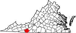 | |
| CDPs | ||
| Unincorporated communities | ||
This article is issued from Wikipedia - version of the 7/27/2016. The text is available under the Creative Commons Attribution/Share Alike but additional terms may apply for the media files.