Laram Q'awa (Pando)
This article is about the mountain in the La Paz Department, Bolivia. For other uses, see Laram Q'awa.
| Laram Q'awa | |
|---|---|
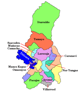
 Laram Q'awa Location in Bolivia | |
| Highest point | |
| Elevation | 4,988 m (16,365 ft) [1] |
| Coordinates | 17°17′03″S 69°24′25″W / 17.28417°S 69.40694°WCoordinates: 17°17′03″S 69°24′25″W / 17.28417°S 69.40694°W |
| Geography | |
| Location |
Bolivia, La Paz Department José Manuel Pando Province |
| Parent range | Andes |
Laram Q'awa (Aymara larama blue, q'awa little river, ditch, crevice, fissure, gap in the earth,[2][3] "blue brook" or "blue ravine", also spelled Laramkahua) is a 4,988-metre-high (16,365 ft) mountain in the Andes of Bolivia. It is situated in the La Paz Department, José Manuel Pando Province, Catacora Municipality. Laram Q'awa lies north-west of the mountains Apachita and Wila Qullu and north-east of Chuqiwa Qullu (Chuquivakkollu).[1][4]
References
- 1 2 Bolivian IGM map 1:50,000 Sinejavi 5742-III
- ↑ Radio San Gabriel, "Instituto Radiofonico de Promoción Aymara" (IRPA) 1993, Republicado por Instituto de las Lenguas y Literaturas Andinas-Amazónicas (ILLLA-A) 2011, Transcripción del Vocabulario de la Lengua Aymara, P. Ludovico Bertonio 1612 (Spanish-Aymara-Aymara-Spanish dictionary)
- ↑ "Diccionario Bilingüe, Castellano - Aymara, Para: Tercera Edición". Félix Layme Pairumani. Retrieved November 7, 2014.
- ↑ "Catacora". INE, Bolivia. Retrieved November 7, 2014. (unnamed)
This article is issued from Wikipedia - version of the 5/12/2016. The text is available under the Creative Commons Attribution/Share Alike but additional terms may apply for the media files.