La Cygne, Kansas
| La Cygne, Kansas | |
|---|---|
| City | |
 Location within Linn County and Kansas | |
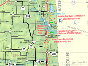 KDOT map of Linn County (legend) | |
| Coordinates: 38°20′49″N 94°45′44″W / 38.34694°N 94.76222°WCoordinates: 38°20′49″N 94°45′44″W / 38.34694°N 94.76222°W | |
| Country | United States |
| State | Kansas |
| County | Linn |
| Incorporated | 1870 |
| Government | |
| • Type | Mayor–Council |
| • Mayor | Terry Weitman |
| Area[1] | |
| • Total | 1.53 sq mi (3.96 km2) |
| • Land | 1.51 sq mi (3.91 km2) |
| • Water | 0.02 sq mi (0.05 km2) |
| Elevation | 837 ft (255 m) |
| Population (2010)[2] | |
| • Total | 1,149 |
| • Estimate (2012[3]) | 1,118 |
| • Density | 760.9/sq mi (293.8/km2) |
| Time zone | CST (UTC-6) |
| • Summer (DST) | CDT (UTC-5) |
| ZIP code | 66040 |
| Area code(s) | 913 |
| FIPS code | 20-37575 |
| GNIS feature ID | 0477688[4] |
| Website | CityOfLaCygne.org |
La Cygne (pronounced luh SEEN) is a city situated along the Marais des Cygnes River in the northeast part of Linn County, located in East Central Kansas, in the Central United States. As of the 2010 census, the city population was 1,149.[5] The city is named after the Marais des Cygnes River which is a French translation of an Osage appellation meaning "marsh of the swans".[6]
History
La Cygne was founded in 1869 as soon as the people were assured of the building of a track for the St. Louis & San Francisco Railroad. A town company was organized and purchased 1,400 acres (5.7 km2) of land, but had only 140 acres (0.57 km2) laid out as a town site. La Cygne was incorporated on January 14, 1870, and a board of trustees was appointed. In the fall of that year the town had grown so that it had inhabitants enough to organize as a city of the third class, and F. A. Foote was elected the first mayor. The first school was taught in 1869 in Cady's hall. It was a private subscription school and was kept open until 1870, when the public school house was built. It was a commodious two-story brick building containing the graded and high schools. The Methodist church organized in 1870 and soon after built a house of worship. The Presbyterian church was organized the same year but had no building for a year afterward.
At an early date La Cygne became a manufacturing point. A flour mill was built in 1870; a bank was started in 1871; the La Cygne organ factory was another early commercial enterprise, but it did not flourish. In 1881 a coal mine was opened, after which it become an important point for the industry. The first newspaper in the town was the Weekly Journal, which first appeared in June 1870.[7]
Geography
La Cygne is located at 38°20′49″N 94°45′44″W / 38.34694°N 94.76222°W (38.346841, -94.762171).[8] The city is situated on the east bank of the Marais des Cygnes River and only a few miles southwest of the city of Linn Valley. It is four miles (6 km) west of U.S. Route 69 on K-152; La Cygne Lake is east of US-69. A track for BNSF Railway passes through the city. According to the United States Census Bureau, the city has a total area of 1.53 square miles (3.96 km2), of which, 1.51 square miles (3.91 km2) is land and 0.02 square miles (0.05 km2) is water.[1]
Climate
The climate in this area is characterized by hot, humid summers and generally mild to cool winters. According to the Köppen Climate Classification system, La Cygne has a humid subtropical climate, abbreviated "Cfa" on climate maps.[9]
Demographics
| Historical population | |||
|---|---|---|---|
| Census | Pop. | %± | |
| 1880 | 835 | — | |
| 1890 | 1,135 | 35.9% | |
| 1900 | 1,037 | −8.6% | |
| 1910 | 957 | −7.7% | |
| 1920 | 1,028 | 7.4% | |
| 1930 | 1,019 | −0.9% | |
| 1940 | 932 | −8.5% | |
| 1950 | 794 | −14.8% | |
| 1960 | 810 | 2.0% | |
| 1970 | 989 | 22.1% | |
| 1980 | 1,025 | 3.6% | |
| 1990 | 1,066 | 4.0% | |
| 2000 | 1,115 | 4.6% | |
| 2010 | 1,149 | 3.0% | |
| Est. 2015 | 1,111 | [10] | −3.3% |
| U.S. Decennial Census[11] 2012 Estimate[12] | |||

2010 census
As of the census[2] of 2010, there were 1,149 people, 454 households, and 303 families residing in the city. The population density was 760.9 inhabitants per square mile (293.8/km2). There were 517 housing units at an average density of 342.4 per square mile (132.2/km2). The racial makeup of the city was 97.3% White, 0.6% African American, 0.9% Native American, 0.2% Asian, 0.1% from other races, and 1.0% from two or more races. Hispanic or Latino of any race were 1.7% of the population.
There were 454 households of which 34.8% had children under the age of 18 living with them, 49.8% were married couples living together, 10.4% had a female householder with no husband present, 6.6% had a male householder with no wife present, and 33.3% were non-families. 29.3% of all households were made up of individuals and 16.7% had someone living alone who was 65 years of age or older. The average household size was 2.53 and the average family size was 3.08.
The median age in the city was 37 years. 28.6% of residents were under the age of 18; 6.4% were between the ages of 18 and 24; 23.5% were from 25 to 44; 24.3% were from 45 to 64; and 17.1% were 65 years of age or older. The gender makeup of the city was 47.3% male and 52.7% female.
2000 census
As of the 2000 census, there were 1,115 people, 459 households, and 294 families residing in the city. The population density was 800.4 people per square mile (309.7/km²). There were 507 housing units at an average density of 363.9 per square mile (140.8/km²). The racial makeup of the city was 96.68% White, 1.43% Native American, 0.27% Black or African American, 0.27% Asian, 0.27% from other races, and 1.08% from two or more races. Hispanic or Latino of any race were 0.72% of the population.
There were 459 households out of which 31.8% had children under the age of 18 living with them, 53.4% were married couples living together, 7.4% had a female householder with no husband present, and 35.9% were non-families. 30.9% of all households were made up of individuals and 18.1% had someone living alone who was 65 years of age or older. The average household size was 2.38 and the average family size was 3.00.
In the city the population was spread out with 26.3% under the age of 18, 6.8% from 18 to 24, 27.7% from 25 to 44, 21.8% from 45 to 64, and 17.4% who were 65 years of age or older. The median age was 37 years. For every 100 females there were 89.0 males. For every 100 females age 18 and over, there were 83.1 males.
The median income for a household in the city was $34,479, and the median income for a family was $44,118. Males had a median income of $30,900 versus $19,803 for females. The per capita income for the city was $15,880. About 5.0% of families and 9.2% of the population were below the poverty line, including 4.9% of those under age 18 and 23.4% of those age 65 or over.
Education
La Cygne is in the Prairie View school district (USD 362), with four schools, serving more than 1,000 students.[13] The four schools located in the school district are:
- La Cygne Elementary School, grades PreK–5
- Prairie View Middle School, grades 6–8
- Prairie View High School, grades 9–12
- Parker Elementary School. grades PreK-5
References
- 1 2 "US Gazetteer files 2010". United States Census Bureau. Retrieved 2012-07-06.
- 1 2 "American FactFinder". United States Census Bureau. Retrieved 2012-07-06.
- ↑ "Population Estimates". United States Census Bureau. Retrieved 2013-05-29.
- ↑ "US Board on Geographic Names". United States Geological Survey. 2007-10-25. Retrieved 2008-01-31.
- ↑ "2010 City Population and Housing Occupancy Status". U.S. Census Bureau. Retrieved May 31, 2011.
- ↑ Penner, Marci (2005). The Kansas Guidebook for Explorers. Inman, Kansas: Kansas Sampler Foundation. p. 230. ISBN 0-9765408-0-0.
- ↑ Frank W. Blackmar, ed. (1912). "La Cygne". Kansas: a cyclopedia of state history, embracing events, institutions, industries, counties, cities, towns, prominent persons, etc ... II. Chicago: Standard Pub Co. p. 91.
- ↑ "US Gazetteer files: 2010, 2000, and 1990". United States Census Bureau. 2011-02-12. Retrieved 2011-04-23.
- ↑ Climate Summary for La Cygne, Kansas
- ↑ "Annual Estimates of the Resident Population for Incorporated Places: April 1, 2010 to July 1, 2015". Retrieved July 2, 2016.
- ↑ United States Census Bureau. "Census of Population and Housing". Retrieved October 23, 2013.
- ↑ "Annual Estimates of the Resident Population: April 1, 2010 to July 1, 2012". Retrieved October 23, 2013.
- ↑ "Prairie View schools". GreatSchools.net. Retrieved 2006-07-04.
External links
| Wikimedia Commons has media related to La Cygne, Kansas. |
- City
- Schools
- USD 362, local school district
- Maps
- La Cygne City Map, KDOT
Municipalities and communities of Linn County, Kansas, United States | ||
|---|---|---|
| Cities | 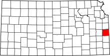 | |
| Unincorporated communities | ||
| Ghost town | ||