Parker, Kansas
| Parker, Kansas | |
|---|---|
| City | |
 Location within Linn County and Kansas | |
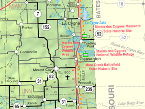 KDOT map of Linn County (legend) | |
| Coordinates: 38°19′44″N 94°59′27″W / 38.32889°N 94.99083°WCoordinates: 38°19′44″N 94°59′27″W / 38.32889°N 94.99083°W | |
| Country | United States |
| State | Kansas |
| County | Linn |
| Area[1] | |
| • Total | 0.27 sq mi (0.70 km2) |
| • Land | 0.27 sq mi (0.70 km2) |
| • Water | 0 sq mi (0 km2) |
| Elevation | 1,004 ft (306 m) |
| Population (2010)[2] | |
| • Total | 277 |
| • Estimate (2012[3]) | 271 |
| • Density | 1,025.9/sq mi (396.1/km2) |
| Time zone | Central (CST) (UTC-6) |
| • Summer (DST) | CDT (UTC-5) |
| ZIP code | 66072 |
| Area code(s) | 913 |
| FIPS code | 20-54500[4] |
| GNIS feature ID | 0477680[5] |
Parker is a city in Linn County, Kansas, United States. As of the 2010 census, the city population was 277.[6]
History
Parker was laid out about 1889. It was named for J. W. Parker, who owned the town site.[7]
The first post office in Parker was established in December 1888.[8]
Geography
Parker is located at 38°19′44″N 94°59′27″W / 38.32889°N 94.99083°W (38.328875, -94.990795).[9] According to the United States Census Bureau, the city has a total area of 0.27 square miles (0.70 km2), all of it land.[1]
Demographics
| Historical population | |||
|---|---|---|---|
| Census | Pop. | %± | |
| 1900 | 306 | — | |
| 1910 | 398 | 30.1% | |
| 1920 | 436 | 9.5% | |
| 1930 | 364 | −16.5% | |
| 1940 | 361 | −0.8% | |
| 1950 | 251 | −30.5% | |
| 1960 | 181 | −27.9% | |
| 1970 | 255 | 40.9% | |
| 1980 | 270 | 5.9% | |
| 1990 | 256 | −5.2% | |
| 2000 | 281 | 9.8% | |
| 2010 | 277 | −1.4% | |
| Est. 2015 | 273 | [10] | −1.4% |
| U.S. Decennial Census | |||
2010 census
As of the census[2] of 2010, there were 277 people, 100 households, and 66 families residing in the city. The population density was 1,025.9 inhabitants per square mile (396.1/km2). There were 115 housing units at an average density of 425.9 per square mile (164.4/km2). The racial makeup of the city was 98.9% White, 0.4% from other races, and 0.7% from two or more races. Hispanic or Latino of any race were 5.4% of the population.
There were 100 households of which 42.0% had children under the age of 18 living with them, 53.0% were married couples living together, 7.0% had a female householder with no husband present, 6.0% had a male householder with no wife present, and 34.0% were non-families. 26.0% of all households were made up of individuals and 10% had someone living alone who was 65 years of age or older. The average household size was 2.77 and the average family size was 3.39.
The median age in the city was 30 years. 33.2% of residents were under the age of 18; 7.8% were between the ages of 18 and 24; 29.7% were from 25 to 44; 18.4% were from 45 to 64; and 10.8% were 65 years of age or older. The gender makeup of the city was 52.3% male and 47.7% female.
2000 census
As of the census[4] of 2000, there were 281 people, 96 households, and 67 families residing in the city. The population density was 1,018.1 people per square mile (387.5/km²). There were 109 housing units at an average density of 394.9 per square mile (150.3/km²). The racial makeup of the city was 97.51% White, 0.36% from other races, and 2.14% from two or more races. Hispanic or Latino of any race were 0.36% of the population.
There were 96 households out of which 43.8% had children under the age of 18 living with them, 59.4% were married couples living together, 8.3% had a female householder with no husband present, and 29.2% were non-families. 24.0% of all households were made up of individuals and 8.3% had someone living alone who was 65 years of age or older. The average household size was 2.93 and the average family size was 3.59.
In the city the population was spread out with 34.9% under the age of 18, 9.6% from 18 to 24, 31.3% from 25 to 44, 11.4% from 45 to 64, and 12.8% who were 65 years of age or older. The median age was 30 years. For every 100 females there were 97.9 males. For every 100 females age 18 and over, there were 92.6 males.
The median income for a household in the city was $24,531, and the median income for a family was $30,625. Males had a median income of $31,250 versus $21,250 for females. The per capita income for the city was $10,110. About 19.2% of families and 23.3% of the population were below the poverty line, including 33.6% of those under the age of eighteen and 21.1% of those sixty five or over.
Notable people
- Sam Brownback - former U.S. Senator and 46th Governor of Kansas.
- Greg Christiansen - author of Raising Meat Goats in a Commercial Operation, ISBN 978-0615584126.
See also
References
- 1 2 "US Gazetteer files 2010". United States Census Bureau. Archived from the original on January 24, 2012. Retrieved 2012-07-06.
- 1 2 "American FactFinder". United States Census Bureau. Retrieved 2012-07-06.
- ↑ "Population Estimates". United States Census Bureau. Archived from the original on June 17, 2013. Retrieved 2013-05-29.
- 1 2 "American FactFinder". United States Census Bureau. Archived from the original on September 11, 2013. Retrieved 2008-01-31.
- ↑ "US Board on Geographic Names". United States Geological Survey. 2007-10-25. Retrieved 2008-01-31.
- ↑ "2010 City Population and Housing Occupancy Status". U.S. Census Bureau. Archived from the original on July 21, 2011. Retrieved April 13, 2011.
- ↑ Kansas State Historical Society (1916). Biennial Report of the Board of Directors of the Kansas State Historical Society. Kansas State Printing Plant. p. 226.
- ↑ "Kansas Post Offices, 1828-1961". Kansas Historical Society. Retrieved 10 June 2014.
- ↑ "US Gazetteer files: 2010, 2000, and 1990". United States Census Bureau. 2011-02-12. Retrieved 2011-04-23.
- ↑ "Annual Estimates of the Resident Population for Incorporated Places: April 1, 2010 to July 1, 2015". Retrieved July 2, 2016.
External links
| Wikimedia Commons has media related to Parker, Kansas. |
- City
- Schools
- USD 362, local school district
- Maps
- Parker City Map, KDOT
Municipalities and communities of Linn County, Kansas, United States | ||
|---|---|---|
| Cities | 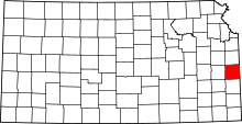 | |
| Unincorporated communities | ||
| Ghost town | ||