Kimberley, Nottinghamshire
| Kimberley | |
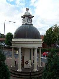 Kimberley War Memorial |
|
 Kimberley |
|
| Population | 6,659 (Cossall and Kimberley ward. 2011) |
|---|---|
| OS grid reference | SK502447 |
| District | Broxtowe |
| Shire county | Nottinghamshire |
| Region | East Midlands |
| Country | England |
| Sovereign state | United Kingdom |
| Post town | NOTTINGHAM |
| Postcode district | NG16 |
| Dialling code | 0115 |
| Police | Nottinghamshire |
| Fire | Nottinghamshire |
| Ambulance | East Midlands |
| EU Parliament | East Midlands |
| UK Parliament | Broxtowe |
|
|
Coordinates: 52°59′51″N 1°15′04″W / 52.9974°N 1.2512°W
Kimberley is a town in Nottinghamshire, England, lying 6 miles northwest of Nottingham along the A610. The town grew as a centre for coal mining, brewing and hosiery manufacturing. Together with the neighbouring villages of Giltbrook, Greasley and Swingate it has a population of around 6,500 people. At the 2011 Census the appropriate ward was Cossall and Kimberley. This had a population of 6,659.[1] There has been no mining or hosiery manufacturing in the town for many years and the local brewery was sold and closed at the end of 2006.
History
Kimberley is referred to as Chinemarelie in William the Conqueror's Domesday Book. With the accession of William to the throne Kimberley came into the possession of William de Peveril.[2] The Peverils lost control when they supported the losing side in the civil war which preceded the accession of Henry II of England in 1154. The King became the owner of the land. King John of England granted land in the area to Ralph de Greasley in 1212 who took up residence at Greasley Castle and also at around this time to Henry de Grey whose son re-built Codnor Castle on the site of an earlier castle established by William Peveril.[3]
Ralph de Greasley's land passed by inheritance and marriage to Nicholas de Cantelupe who took part in Edward III of England's Scottish campaigns and also the Battle of Crécy. Nicholas founded Beauvale Priory using part of his Kimberley holding in 1343. That part of Kimberley which had become the property of Beauvale Priory was claimed by King Henry VIII during the Dissolution of the Monasteries in the 16th century.[3]
The Priory's land was redistributed by the King and came into the possession of Arthur Capell, 1st Baron Capell of Hadham again by inheritance and marriage in 1627. Arthur was beheaded in 1649 having fought for the Royalists in the English Civil War. Arthur's son was created Earl of Essex in 1661.[3]
In 1753 the land was purchased by Sir Matthew Lamb whose grandson William Lamb became Prime Minister in 1834. The Lamb's Kimberley estates passed by marriage to the 5th Earl Cowper in 1805 and on the death of the 7th Earl in 1913 were sold off in pieces.[3]
That part of Kimberley retained by the Cantelupe's passed by inheritance and marriage to John Lord Zouch who died at the Battle of Bosworth with Richard III in 1485. He was posthumously found guilty of high treason with his property forfeited to Henry VII. John Savage (-1491) received this part of Kimberley in gratitude for his efforts on behalf of Henry VII at Bosworth. The Savage family sold this land to the Earl of Rutland in the early 17th century. The Duke of Rutland's Kimberley estates were sold in parcels in the early 19th century.[3]
Airships over Kimberley

Airships have flown over Kimberley on a number of occasions. The R101 flew over Kimberley during a trial flight on 18 October 1929, the year before it crashed with the loss of most of its passengers and crew during a flight to India.[4] During a bombing raid on the Bennerley and Stanton Ironworks during World War One, a German Zeppelin airship, L.20 (LZ 59) overflew Kimberley.[5] The R101 and the L.20 were rigid airships but more recently, in August 1997 a non-rigid airship advertising the RAC flew over Kimberley.[6]
Kimberley today
One of Kimberley's most notable structures is its unusual war memorial, in the form of a rotunda which is used as the emblem of Kimberley School. This secondary school has a catchment area which extends into the neighbouring areas of Nuthall, Eastwood, Watnall, and Hempshill Vale.

On the South side of Kimberley lies Swingate, which has many different walking and cycling routes into the woods and surrounding countryside.
The twin towns of Kimberley are Échirolles in France and Grugliasco in Italy.[7]
Kimberley Brewery was taken over by Greene King in 2006, another major brewer in a multi million pound deal which marked the end of the traditional Kimberley Ales as ale brewing ceased shortly afterwards and only a distribution centre remained there.
The former Kimberley Brewery site has within its boundaries a geological Site of Special Scientific Interest (SSSI). It is listed under the title of "Kimberley Railway Cutting"[8] as an important location for Permian Gymnosperm fossils. The Permian - Carboniferous unconformity can be found in the Kimberley Railway Cutting.
Since 1974, Kimberley has been part of the Borough of Broxtowe. From 1894 to 1974, however, it was part of Basford Rural District Council
Recently there has been speculation that the Nottingham Express Tram (NET) want to extend their Phoenix Park tram stop into Kimberley towards Giltbrook Retail Park[9]
Famous residents
- John Reynolds was British Superbike Champion, 1992, 2001 and 2004[10]
- Sergeant Richard Bolitho was the Rear Gunner on a Lancaster bomber which crashed with the loss of the whole crew during the Dambuster raid in World War II.[11]
Sport

- Kimberley Town F.C. were the main local football team until they folded in 2012.
- Kimberley Miners Welfare F.C.
- Kimberley Institute Cricket Club is the town's cricket team.
- Awsworth - Kimberley & District Rifle Club
See also
References
- ↑ "Broxtowe ward population 2011". Neighbourhood Statistics. Office for National Statistics. Retrieved 11 April 2016.
- ↑ Domesday Book: A Complete Transliteration. London: Penguin, 2003. ISBN 0-14-143994-7 p.772
- 1 2 3 4 5 Lee, J.M.,. A Brief History of Kimberley.
- ↑ Plumb, Arthur. Kimberley in old picture postcards Volume 6.
- ↑ Phyllis Drew. "Chinemarelian (Kimberley) Historical Society Newsletter 32".
- ↑ "RAC Airship". The Independent. London. 12 July 1997. Retrieved 2010-05-07.
- ↑ "Twin Towns".
- ↑ "Kimberley Railway Cutting".
- ↑ http://www.eastmidlandsnews.org.uk/news/tram-extension-supporters-of-line-to-kimberley-walk-route
- ↑ "John Reynolds".
- ↑ "Richard Bolitho".
Further reading
- Domesday Book: A Complete Transliteration. London: Penguin. 2003. ISBN 0-14-143994-7.
- Ottewell, David (2001). Old Kimberley. Stenlake Publishing. ISBN 1-84033-155-0.
- Lee, John.M. (2001). A Brief History of Kimberley (First ed.).
- Plumb, Arthur (1993). Kimberley in old picture postcards. European Library. ISBN 90-288-4669-7.
External links
| Unitary authorities | |
|---|---|
| Boroughs or districts | |
| Major settlements | |
| Topics | |