Kenvir, Kentucky
| Kenvir, Kentucky | |
|---|---|
| Census-designated place (CDP) | |
 Kenvir, Kentucky | |
| Coordinates: 36°51′13″N 83°09′26″W / 36.85361°N 83.15722°WCoordinates: 36°51′13″N 83°09′26″W / 36.85361°N 83.15722°W | |
| Country | United States |
| State | Kentucky |
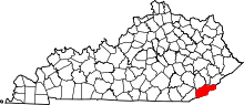
| County | Harlan |
| Area[1] | |
| • Total | 0.292 sq mi (0.76 km2) |
| • Land | 0.292 sq mi (0.76 km2) |
| • Water | 0 sq mi (0 km2) |
| Elevation | 1,457 ft (444 m) |
| Population (2010)[2] | |
| • Total | 297 |
| • Density | 1,000/sq mi (390/km2) |
| Time zone | Eastern (EST) (UTC-5) |
| • Summer (DST) | EDT (UTC-4) |
| Area code(s) | 606 |
| GNIS feature ID | 495684[3] |
Kenvir is a census-designated place and unincorporated community in Harlan County, Kentucky, United States. Its population was 297 as of the 2010 census.[2]
References
- ↑ "US Gazetteer files: 2010, 2000, and 1990". United States Census Bureau. 2011-02-12. Retrieved 2011-04-23.
- 1 2 "American FactFinder". United States Census Bureau. Retrieved 2011-05-14.
- ↑ "Kenvir". Geographic Names Information System. United States Geological Survey.
This article is issued from Wikipedia - version of the 9/18/2014. The text is available under the Creative Commons Attribution/Share Alike but additional terms may apply for the media files.