Harlan, Kentucky
| Harlan, Kentucky | |
|---|---|
| City | |
|
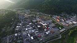
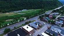
Harlan, Kentucky in 2015. | |
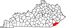
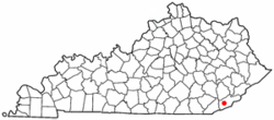 Location of Harlan, Kentucky | |
| Coordinates: 36°50′29″N 83°19′12″W / 36.84139°N 83.32000°WCoordinates: 36°50′29″N 83°19′12″W / 36.84139°N 83.32000°W | |
| Country | United States |
| State | Kentucky |
| County | Harlan |
| Named for | Its county |
| Area | |
| • Total | 1.8 sq mi (4.5 km2) |
| • Land | 1.8 sq mi (4.5 km2) |
| • Water | 0.0 sq mi (0.0 km2) |
| Elevation | 1,191 ft (363 m) |
| Population (2010) | |
| • Total | 1,745 |
| • Density | 969.5/sq mi (387.8/km2) |
| Time zone | Eastern (EST) (UTC-5) |
| • Summer (DST) | EDT (UTC-4) |
| ZIP code | 40831 |
| Area code(s) | 606 |
| FIPS code | 21-34732 |
| GNIS feature ID | 0493746 |
Harlan is a city in and the county seat of Harlan County, Kentucky, United States.[1] The population was 1,745 at the 2010 census.
Harlan is one of three Kentucky county seats to share its name with its county, the others being Greenup and Henderson.
History
Harlan was first settled by Samuel and Chloe Howard in 1796. Upon the founding of Harlan County (named for Kentucky pioneer Silas Harlan) in 1819, the Howards donated 12 acres (49,000 m2) of land to serve as the county seat.[2] The community there was already known as Mount Pleasant, apparently owing to a nearby Indian mound. A post office was established on Sept. 19, 1828, but called Harlan Court House due to another Mt. Pleasant preëmpting that name.[3] During the Civil War, Confederate raiders under Gen. Humphrey Marshall occupied the town; the local postmaster renamed the community Spurlock after himself;[3] and, in October 1863, the courthouse was burnt down in reprisal for the Union destruction of the courthouse in Lee County, Virginia.[2] In 1865, the post office was renamed Harlan and, although the community was formally incorporated by the state assembly as Mount Pleasant in on Apr. 15, 1884,[4] the town was already usually called Harlan Court House or Harlan Town by its inhabitants.[3] The city's terms of incorporation were amended to change the name to Harlan on Mar. 13, 1912. One year before, the L&N had arrived in Harlan and prompted massive growth. The city had initially expanded east along Clover Fork; after World War II, it also expanded south along Martin's Fork.[2]
Harlan is the site of a criminal case in which a man, Condy Dabney, was convicted in 1924 of murdering a person who was later found alive.[5]
A flood in 1977 prompted federal aid that diverted Clover Fork into man-made tunnels under Ivy Hill in 1989.[2] In the 1990s, a flood wall was also completed on the city's west side along the four-lane bypass U.S. Route 421.
Geography
Harlan is located at 36°50′29″N 83°19′12″W / 36.84139°N 83.32000°W (36.841487, -83.320066).[6]
According to the United States Census Bureau, the city has a total area of 1.8 square miles (4.7 km2), all land.
Climate
The climate in this area is characterized by hot, humid summers and generally mild to cool winters. According to the Köppen Climate Classification system, Harlan has a humid subtropical climate, abbreviated "Cfa" on climate maps.[7]
Demographics
| Historical population | |||
|---|---|---|---|
| Census | Pop. | %± | |
| 1890 | 361 | — | |
| 1900 | 557 | 54.3% | |
| 1910 | 657 | 18.0% | |
| 1920 | 2,647 | 302.9% | |
| 1930 | 4,327 | 63.5% | |
| 1940 | 5,122 | 18.4% | |
| 1950 | 4,786 | −6.6% | |
| 1960 | 4,177 | −12.7% | |
| 1970 | 3,318 | −20.6% | |
| 1980 | 3,024 | −8.9% | |
| 1990 | 2,686 | −11.2% | |
| 2000 | 2,081 | −22.5% | |
| 2010 | 1,745 | −16.1% | |
| Est. 2015 | 1,639 | [8] | −6.1% |
As of the census[10] of 2000, there were 2,081 people, 926 households, and 550 families residing in the city. The population density was 1,187.4 people per square mile (459.1/km²). There were 1,060 housing units at an average density of 604.8 per square mile (2.339/km²). The racial makeup of the city was 91.01% White, 7.02% Black or African American, 0.29% Native American, 0.86% Asian, and 0.82% from two or more races. Hispanics or Latinos of any race were 0.62% of the population.
There were 926 households out of which 24.0% had children under the age of 18 living with them, 41.3% were married couples living together, 14.4% had a female householder with no husband present, and 40.6% were non-families. 39.0% of all households were made up of individuals and 19.4% had someone living alone who was 65 years of age or older. The average household size was 2.17 and the average family size was 2.91.
In the city the population was spread out with 21.3% under the age of 18, 8.1% from 18 to 24, 25.8% from 25 to 44, 25.1% from 45 to 64, and 19.7% who were 65 years of age or older. The median age was 42 years. For every 100 females there were 89.4 males. For every 100 females age 18 and over, there were 81.8 males.
The median income for a household in the city was $17,270, and the median income for a family was $29,135. Males had a median income of $37,500 versus $20,852 for females. The per capita income for the city was $15,572. About 23.8% of families and 32.4% of the population were below the poverty line, including 40.0% of those under age 18 and 20.6% of those age 65 or over.
Educational institutions
Two school districts, the Harlan County Public Schools and the Harlan Independent Schools, are based in the city. The independent schools, whose district roughly coincides with the city limits of Harlan, feature Harlan Elementary, Harlan Middle, and Harlan High.
Harlan County High School, which opened in 2008 as the consolidation of the county district's three previous high schools (James A. Cawood, Evarts, and Cumberland), serves all other public high school students in the county. Harlan also features a campus of Southeast Kentucky Community and Technical College.
Media
The Harlan Daily Enterprise newspaper is published Monday through Saturday. Radio stations serving Harlan are WHLN (adult contemporary, 1410 AM), WFSR (gospel, 970 AM) and WTUK (country, 105.1 FM).
Some storylines of the FX Networks drama Justified take place in Harlan, although no scenes have been filmed there. The 2012-13 National Geographic series "Kentucky Justice" which followed the Harlan County Sheriff's Office in their daily duties was filmed in Harlan and Harlan County.
Harlan was also featured in the Darrell Scott song "You'll Never Leave Harlan Alive" (later performed by Brad Paisley), the Steve Earle song "Harlan Man", the Anna McGarrigle song "Goin' Back to Harlan" (notably covered by Emmylou Harris) and the song "Harlan County Line" from Dave Alvin.
Notable people
- Maxine Cheshire - journalist
- Karl Spillman Forester - federal judge for the United States District Court for the Eastern District of Kentucky
- Wallace Jones - NBA player
- James E. Keller - former Justice of the Kentucky Supreme Court
- Nick Lachey - singer
- Cawood Ledford - University of Kentucky basketball and football announcer
- George Ella Lyon - author
- Jordan Smith - musician and winner of Season 9 of The Voice
- Green Wix Unthank - United States District Court judge
- Don Whitehead - two-time Pulitzer Prize-winning reporter and author
External links
| Wikimedia Commons has media related to Harlan, Kentucky. |
References
- ↑ "Find a County". National Association of Counties. Retrieved 2011-06-07.
- 1 2 3 4 Greene, James III. The Kentucky Encyclopedia, p. 408. "Harlan". University Press of Kentucky (Lexington), 1992. Accessed 30 Jul 2013.
- 1 2 3 Rennick, Robert M. (1987). Kentucky Place Names. University Press of Kentucky. p. 131. Retrieved 28 Apr 2013.
- ↑ Commonwealth of Kentucky. Office of the Secretary of State. Land Office. "Harlan, Kentucky". Accessed 29 Jul 2013.
- ↑ Borchard, Edwin M (1932). Convicting the Innocent; Sixty-Five Actual Errors of Criminal Justice. p. 55. ISBN 1-4086-7960-4.
- ↑ "US Gazetteer files: 2010, 2000, and 1990". United States Census Bureau. 2011-02-12. Retrieved 2011-04-23.
- ↑ Climate Summary for Harlan, Kentucky
- ↑ "Annual Estimates of the Resident Population for Incorporated Places: April 1, 2010 to July 1, 2015". Retrieved July 2, 2016.
- ↑ "Census of Population and Housing". Census.gov. Retrieved June 4, 2015.
- ↑ "American FactFinder". United States Census Bureau. Retrieved 2008-01-31.