Karlsborg Municipality
| Karlsborg Municipality Karlsborgs kommun | ||
|---|---|---|
| Municipality | ||
| ||
 | ||
| Country | Sweden | |
| County | Västra Götaland County | |
| Seat | Karlsborg | |
| Area[1] | ||
| • Total | 797.35 km2 (307.86 sq mi) | |
| • Land | 405.87 km2 (156.71 sq mi) | |
| • Water | 391.48 km2 (151.15 sq mi) | |
| Area as of January 1, 2014. | ||
| Population (June 30, 2016)[2] | ||
| • Total | 6,844 | |
| • Density | 8.6/km2 (22/sq mi) | |
| Time zone | CET (UTC+1) | |
| • Summer (DST) | CEST (UTC+2) | |
| ISO 3166 code | SE | |
| Province | Västergötland | |
| Municipal code | 1446 | |
| Website | www.karlsborg.se | |

Karlsborg Municipality (Karlsborgs kommun) is a municipality in Västra Götaland County in western Sweden. Its seat is located in the town of Karlsborg.
The present municipality was formed in 1971 when "old" Karlsborg was amalgamated with Mölltorp and Undenäs.
The area has been dominated by Karlsborg Fortress and military activity throughout the last centuries.
Tiveden National Park is partly situated within the municipality. The Flugebyn airfield, home of the Västergötland Skydiving Club (Västergötlands Fallskärmsklubb) also lies in the municipality.
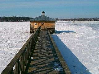
Sauna on Lake Vättern, picture taken in Karlsborg
References
- ↑ "Statistiska centralbyrån, Kommunarealer den 1 januari 2014" (Microsoft Excel) (in Swedish). Statistics Sweden. Retrieved 2014-04-18.
- ↑ "Folkmängd i riket, län och kommuner 30 juni 2016" (in Swedish). Statistics Sweden. August 17, 2016. Retrieved August 17, 2016.
External links
- Karlsborg Municipality - Official site
Coordinates: 58°32′N 14°31′E / 58.533°N 14.517°E
This article is issued from Wikipedia - version of the 1/31/2015. The text is available under the Creative Commons Attribution/Share Alike but additional terms may apply for the media files.