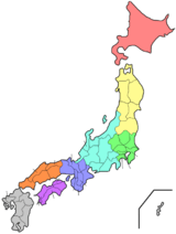
Kanagawa Prefecture
| Kanagawa Prefecture 神奈川県 | |||
|---|---|---|---|
| Prefecture | |||
| Japanese transcription(s) | |||
| • Japanese | 神奈川県 | ||
| • Rōmaji | Kanagawa-ken | ||
| |||
 | |||
| Coordinates: 35°26′51.03″N 139°38′32.44″E / 35.4475083°N 139.6423444°ECoordinates: 35°26′51.03″N 139°38′32.44″E / 35.4475083°N 139.6423444°E | |||
| Country | Japan | ||
| Region | Kantō | ||
| Island | Honshu | ||
| Capital | Yokohama | ||
| Government | |||
| • Governor | Yūji Kuroiwa (since April 2011) | ||
| Area | |||
| • Total | 2,416.04 km2 (932.84 sq mi) | ||
| Area rank | 43rd | ||
| Population (September 1, 2014) | |||
| • Total | 9,098,984 | ||
| • Rank | 2nd | ||
| • Density | 3,770/km2 (9,800/sq mi) | ||
| ISO 3166 code | JP-14 | ||
| Districts | 6 | ||
| Municipalities | 33 | ||
| Flower | Golden-rayed lily (Lilium auratum) | ||
| Tree | Ginkgo (Ginkgo biloba) | ||
| Bird | Common gull (Larus canus) | ||
| Website |
www | ||


Kanagawa Prefecture (神奈川県 Kanagawa-ken) is a prefecture located in southern Kantō region of Japan.[1] The capital of the prefecture is Yokohama.[2] Kanagawa is part of the Greater Tokyo Area. Kanagawa Prefecture is home to Kamakura and Hakone, two highly popular side trip destinations from Tokyo.
History
The prefecture has some archaeological sites going back to the Jomon period (around 400 BCE). About 3,000 years ago, Mount Hakone produced a volcanic explosion which resulted in Lake Ashi on the western area of the prefecture.
It is believed that the Yamato Dynasty ruled this area from the 5th century onwards. In the ancient era, its plains were very sparsely inhabited.
In medieval Japan, Kanagawa was part of the provinces of Sagami and Musashi.[3] Kamakura in central Sagami was the capital of Japan during the Kamakura period (1185–1333).
During the Edo period, the western part of Sagami Province was governed by the daimyo of Odawara Castle, while the eastern part was directly governed by the Tokugawa Shogunate in Edo (Tokyo).
Commodore Matthew Perry landed in Kanagawa in 1853 and 1854 and signed the Convention of Kanagawa to force open Japanese ports to the United States. Yokohama, the largest deep-water port in Tokyo Bay, was opened to foreign traders in 1859 after several more years of foreign pressure, and eventually developed into the largest trading port in Japan. Nearby Yokosuka, closer to the mouth of Tokyo Bay, developed as a naval port and now serves as headquarters for the U.S. 7th Fleet and the fleet operations of the Japan Maritime Self-Defense Force. After the Meiji Period, many foreigners lived in Yokohama City, and visited Hakone. The Meiji Government developed the first railways in Japan, from Shinbashi (in Tokyo) to Yokohama in 1872.
The epicenter of the Great Kantō earthquake in 1923 was deep beneath Izu Ōshima Island in Sagami Bay. It devastated Tokyo, the port city of Yokohama, surrounding prefectures of Chiba, Kanagawa, and Shizuoka, and caused widespread damage throughout the Kantō region.[4] The sea receded as much as 400 metres from the shore at Manazuru Point, and then rushed back towards the shore in a great wall of water which swamped Mitsuishi-shima.[5] At Kamakura, the total death toll from earthquake, tsunami, and fire exceeded 2,000 victims.[6] At Odawara, ninety percent of the buildings collapsed immediately, and subsequent fires burned the rubble along with anything else left standing.[7]
Yokohama, Kawasaki and other major cities were heavily damaged by the U.S. bombing in 1945. Casualties amounted to more than several thousand. After the war, General Douglas MacArthur, the chief commander of Supreme Commander of the Allied Powers for the Occupation of Japan, landed in Kanagawa, before moving to other areas. U.S. military bases still remain in Kanagawa, including Camp Zama (Army), Yokosuka Naval Base, Naval Air Station Atsugi (Navy).
In 1945, Kanagawa was the 15th most populous prefecture in Japan, with the population of about 1.9 million. In the years after the war, the prefecture underwent rapid urbanization as a part of the Greater Tokyo Area. The population as of September 1, 2014 is estimated to be 9.1 million.[8] Kanagawa became the second most populous prefecture in 2006.
Geography
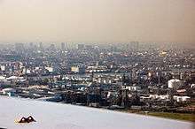
Kanagawa is a relatively small prefecture located at the southeastern corner of the Kantō Plain[9] wedged between Tokyo on the north, the foothills of Mount Fuji on the northwest, and the Sagami Bay[9] and Tokyo Bay on the south and east. The eastern side of the prefecture is relatively flat and heavily urbanized, including the large port cities of Yokohama and Kawasaki.
The southeastern area nearby the Miura Peninsula is less urbanized, with the ancient city of Kamakura drawing tourists to temples and shrines. The western part, bordered by Yamanashi Prefecture and Shizuoka Prefecture on the west,[10] is more mountainous and includes resort areas like Odawara and Hakone. The area, stretching 80 kilometres (50 mi) from west to east and 60 kilometres (37 mi) from north to south, contains 2,400 square kilometres (930 sq mi) of land, accounting for 0.64% of the total land area of Japan.[10]
As of 1 April 2012, 23% of the total land area of the prefecture was designated as Natural Parks, namely the Fuji-Hakone-Izu National Park; Tanzawa-Ōyama Quasi-National Park; and Jinba Sagamiko, Manazuru Hantō, Okuyugawara, and Tanzawa-Ōyama Prefectural Natural Parks.[11]
Topography
Topographically, the prefecture consists of three distinct areas. The mountainous western region features the Tanzawa Mountain Range and Hakone Volcano. The hilly eastern region is characterized by the Tama Hills and Miura Peninsula. The central region, which surrounds the Tama Hills and Miura Peninsula, consists of flat stream terraces and low lands around major rivers including the Sagami River, Sakai River, Tsurumi River, and Tama River.[10]
The Tama River forms much of the boundary between Kanagawa and Tokyo. The Sagami River flows through the middle of the prefecture. In the western region, the Sakawa (river) runs through a small lowland, the Sakawa Lowland, between Hakone Volcano to the west and the Ōiso Hills to the east and flows into Sagami Bay.[9]
The Tanzawa Mountain Range, part of the Kantō Mountain Range, contains Mount Hiru (1,673 m or 5,489 ft), the highest peak in the prefecture. Other mountains measure similar mid-range heights: Mount Hinokiboramaru (1,601 m or 5,253 ft), Mount Tanzawa, (1,567 m or 5,141 ft), Mount Ōmuro (1,588 m or 5,210 ft), Mount Himetsugi (1,433 m or 4,701 ft), and Mount Usu (1,460 m or 4,790 ft). The mountain range is lower in height southward leading to Hadano Basin to the Ōiso Hills. At the eastern foothills of the mountain range lies the Isehara Plateau and across the Sagami River the Sagami Plateau.[9]
Cities

Nineteen cities are located in Kanagawa Prefecture:


Towns and villages

These are the towns and villages in each district:
Mergers
Festivals and events

- Tama River Firework event
- Yokohama Port Anniversary Festival (June)
- Kamakura Festival (April)
- Hiratsuka Tanabata Festival (July)
- Odawara Hōjō Godai Festival (May)
- Yugawara Kifune Festival (July)
Transportation
Kanagawa's transport network is heavily intertwined with that of Tokyo (see: Transportation in Greater Tokyo). Shin-Yokohama and Odawara stations on the Tōkaidō Shinkansen are located in the prefecture, providing high-speed rail service to Tokyo, Nagoya, Osaka, and other major cities.
Railways
- East Japan Railway Company
- Central Japan Railway Company
- Keikyu
- Odakyu
- Sagami Railway
- Tokyu
- Minatomirai Line
- Keio
- Izuhakone Railway
- Enoshima Electric Railway
Subways
- Yokohama Municipal Subway
- Blue Line
- Green Line
Monorail
People movers
Road
Expressway
National highways
- Route 1
- Route 15
- Route 16
- Route 20
- Route 129 (Hiratsuka-Atsugi-Sagamihara)
- Route 132
- Route 133
- Route 134
- Route 135 (Shimoda–Atami-Odawara)
- Route 138
- Route 246 (Chiyoda, Tokyo-Kawasaki-Machida-Atsugi-Isehara-Gotenba–Numazu)
- Route 255
- Route 357 (Chiba–Funabashi–Daiba of Tokyo-Yokohama-Yokosuka)
- Route 409
- Route 412
- Route 413 (Fujiyoshida–Lake Yamanaka-Sagamihara)
- Route 466 (Setagaya, Tokyo-Kawasaki-Yokohama)
- Route 467
Ports
- Yokohama Port – International container hub port
- Misaki Port – Ferry Route to Kisarazu
Education
The Kanagawa Prefectural Board of Education manages and oversees individual municipal school districts. The board of education also directly operates most of the public high schools in the prefecture.
University facilities
- Kawasaki
- Keio University – Shin Kawasaki Campus
- Meiji University – Ikuta Campus
- Senshu University – Ikuta Campus
- Japan Women's University
- Showa University of Music
- Den-en Chofu University – Aso Ward
- Nippon Medical School
- St. Marianna University, School of Medicine – Miyamae
- Japan Cinema School
- Tokyo City University – Aso Ward
- Yokohama
- Tokyo Institute of Technology – Suzukakedai
- Tokyo University of the Arts – Naka Ward
- Yokohama National University – Hodogaya
- Yokohama City University – Kanazawa Ward
- Kanagawa University – Kanagawa Ward
- Kanto Gakuin University – Kanazawa Ward
- Toin University of Yokohama – Aoba Ward
- Tsurumi University – Tsurumi Ward
- Yokohama College of Commerce – Tsurumi Ward
- Yokohama College of Pharmacy – Totsuka Ward
- Keio University – Hiyoshi Campus
- Tokyo City University – Tsuzuki Ward
- Meiji Gakuin University – Totsuka Ward
- Nippon Sport Science University – Aoba Ward
- Toyo Eiwa University – Midori Ward
- Kokugakuin University – Tama Plaza
- Senzoku Gakuen College of Music
- Sagamihara
- Aoyama Gakuin University
- Azabu University
- Kitasato University
- Sagami Women's University
- Obirin University
- Joshi University of Art and Design
- Teikyo University
- Yokosuka
- Hiratsuka
- Tokai University – Hiratsuka Campus
- Shoin University – Hiratsuka Campus
- Kanagawa University
- Isehara
- Tokai University – Isehara Campus
- Sanno University
- Odawara
- Kanto Gakuin University – Odawara Campus
- International University of Health and Welfare
- Chigasaki
- Bunkyo University – Chigasaki Campus
- Atsugi
- Shoin University
- Tokyo University of Agriculture – Atsugi Campus
- Kanagawa Institute of Technology
- Tokyo Polytechnic University – Atsugi Campus
Sports
Facilities
Football and athletics
- Nissan Stadium (International Stadium Yokohama)—in Yokohama, the final venue of 2002 FIFA World Cup and FIFA Club World Cup in 2005–2007
- Nippatsu Mitsuzawa Stadium (Mitsuzawa Stadium)—in Yokohama, only for football
- Todoroki Athletics Stadium—in Kawasaki, the final venue of 2007 IFAF World Cup (American football).
- Hiratsuka Athletics Stadium
Baseball
- Yokohama Stadium—for baseball (Yokohama DeNA BayStars) and hosted Australian rules football
- Kawasaki Stadium—former homeground of Taiyo Whales (now Yokohama BayStars) and Lotte Orions (now Chiba Lotte Marines).
- Yokosuka Stadium—home field of Shonan Searex, minor league team of Yokohama BayStars
Indoor
- Yokohama Arena—also for music concert
- Yokohama Cultural Gymnasium—a volleyball venue of 1964 Summer Olympics in Tokyo
- Todoroki Arena—in Kawasaki and multi-purpose venue (including baseketball)
- Odawara Arena—2020 Kanagawa Pre-Games training facilities
Other
- Enoshima Yacht Course—used for 1964 Summer Olympics.
- Hakone Ekiden Course—from Tokyo to Hakone, 108.0 km, mostly on Japan National Route 1 and Route 15. Runners run on the divided route for ten parts on January 2 (to Hakone) and January 3 (to Tokyo) every year.
- Lake Sagami—hosted canoeing and rowing for the 1964 Summer Olympics.
Teams
Soccer (football)
- Kawasaki Frontale (Kawasaki)—Todoroki Athletics
- Yokohama F. Marinos (Yokohama, Yokosuka)—Nissan Stadium
- Yokohama F.C. (Yokohama)—Mitsuzawa Ballpark
- Shonan Bellmare (Hiratsuka, Odawara and some cities and towns in central and western area of Kanagawa)—Hiratsuka Athletic Stadium (football) and Odawara Arena (futsal)
Baseball
- Yokohama BayStars (Yokohama)—Yokohama Stadium, and Yokosuka Stadium (for its farm team, "Shonan Searex").
Basketball
Volleyball
- NEC Red Rockets (Kawasaki)—Todoroki Arena
Visitors attractions and places of interest
Sister areas
Kanagawa Prefecture has sister relationships with these places: [12]
 Maryland, United States (1981)
 Liaoning Province, China (1983)
 Odessa Oblast, Ukraine (1986)
 Baden-Württemberg, Germany (1989)
 Gyeonggi Province, Republic of Korea (1990)
 City of Gold Coast, Australia (1990)
 Penang, Malaysia (1991)
 Västra Götaland County, Sweden (1998)
In popular culture
- Stephen Sondheim's stage musical Pacific Overtures, about the "opening" of Japan to Western influence by Commodore Perry, contains the song "Welcome to Kanagawa".
- The main team in the Japanese manga and anime series Slam Dunk, Shohoku, is from Kanagawa.
- The Hinata Inn and surrounding town from the manga and anime series Love Hina are located in Kanagawa.
- The Japanese manga series Elfen Lied takes place in Kanagawa, mainly in Kamakura and Enoshima (Fujisawa).
- The Japanese anime series S-CRY-ED takes place in Kanagawa Prefecture, after a seismic event raises it from the ground.
- The Japanese manga and anime series Kenkō Zenrakei Suieibu Umishō takes place in the fictional Kanagawa city of Umineko.
- The Japanese anime series Gundam Wing's early episodes feature Kanagawa prominently, mainly Yokohama and Yokosuka.
- The Japanese anime and manga series Area no Kishi takes place in Kanagawa, mostly Kamakura.
- The Japanese anime and manga series Hamatora takes place in Kanagawa, mainly in Yokohama.
- The Japanese anime and manga series His and Her Circumstances takes place in Kanagawa Prefecture, mainly in Kawasaki city and Yokohama.
- The Japanese anime and manga series Neon Genesis Evangelion takes place in Tokyo-3, which is located in the village of Hakone, in the Ashigarashimo District
- A team from the Japanese anime and manga series Kuroko's Basketball, Kaijo, is from Kanagawa.
- The manga Shonan Junai Gumi, along with its prequel bad company, and the Great Teacher Onizuka's (sequel to Shonan Junai Gumi) spin off "shonan 14 days", are set in Shonan, in Kanagawa
See also
Notes
- ↑ Nussbaum, Louis-Frédéric. (2005). "Kanagawa" in Japan Encyclopedia, p. 466, p. 466, at Google Books; "Kantō" in p. 479, p. 479, at Google Books.
- ↑ Nussbaum, "Yokohama" in pp. 1054–1055, p. 154, at Google Books.
- ↑ Nussbaum, "Provinces and prefectures" in p. 466, p. 466, at Google Books.
- ↑ Hammer, Joshua. (2006). Yokohama Burning: the Deadly 1923 Earthquake and Fire that Helped Forge the Path to World War II, p. 278, p. 278, at Google Books.
- ↑ Hammer, pp. 114-115, p. 114, at Google Books.
- ↑ Hammer, pp. 115-116, p. 115, at Google Books.
- ↑ Hammer, p. 113, p. 113, at Google Books.
- ↑ 神奈川県人口統計調査公表資料 (Report). 2014.
- 1 2 3 4 Kanagawa terrain (Japanese) (Translate to English: Google, Bing)
- 1 2 3 Overview of the prefectural geography (Japanese) (Translate to English: Google, Bing)
- ↑ "General overview of area figures for Natural Parks by prefecture" (PDF). Ministry of the Environment. Retrieved 16 August 2012.
- ↑ "Friendly/Sister Affiliations of Kanagawa Prefecture and the Municipalities : Kanagawa". Kanagawa Prefectural Government. February 1, 2016. Retrieved July 17, 2016.
References
- Hammer, Joshua. (2006). Yokohama Burning: The Deadly 1923 Earthquake and Fire that Helped Forge the Path to World War II. New York: Simon & Schuster. ISBN 9780743264655; OCLC 67774380
- Nussbaum, Louis-Frédéric and Käthe Roth. (2005). Japan encyclopedia. Cambridge: Harvard University Press. ISBN 978-0-674-01753-5; OCLC 58053128
External links
| Wikimedia Commons has media related to Kanagawa prefecture. |
| Wikivoyage has a travel guide for Kanagawa Prefecture. |
- Official Kanagawa Prefecture website
- Official Kanagawa Living website
- Kanagawa Prefectural Tourist Association website (English)
| Wards of Yokohama | ||
|---|---|---|
| Wards of Kawasaki | ||
| Wards of Sagamihara | ||
| Core city | ||
| Special cities | ||
| Cities | ||
| Aikō District | ||
| Ashigarakami District | ||
| Ashigarashimo District | ||
| Kōza District | ||
| Miura District | ||
| Naka District | ||