Odawara
| Odawara 小田原市 | |||
|---|---|---|---|
| Special city | |||
|
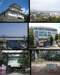
Top left: Odawara Castle, Top right;Panorama view of around Odawara, from Odawara Castle Park, Middle left: Odawara Fishing Port, Middle right: Odawara Station, Bottom left: Sontoku Ninomiya Shrine, Bottom right: Ishigakiyama Castle Park | |||
| |||
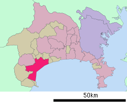 Location of Odawara in Kanagawa Prefecture | |||
 Odawara
| |||
| Coordinates: 35°15′N 139°9′E / 35.250°N 139.150°ECoordinates: 35°15′N 139°9′E / 35.250°N 139.150°E | |||
| Country | Japan | ||
| Region | Kantō | ||
| Prefecture | Kanagawa Prefecture | ||
| Government | |||
| • - Mayor | Kenichi Kato (since May 2008) | ||
| Area | |||
| • Total | 113.79 km2 (43.93 sq mi) | ||
| Population (February 1, 2015) | |||
| • Total | 194,672 | ||
| • Density | 1,710/km2 (4,400/sq mi) | ||
| Time zone | Japan Standard Time (UTC+9) | ||
| City symbols | |||
| • Tree | Japanese black pine | ||
| • Flower | Ume | ||
| • Bird | Little tern | ||
| • Fish | Medaka, Carangidae | ||
| Phone number | 0465-33-1302 | ||
| Address | 300 Ogikubo, Odawara-shi, Kanagawa-ken 250-8555 | ||
| Website |
www | ||


Odawara (小田原市 Odawara-shi) is a city located in western Kanagawa Prefecture, Japan.
As of February 2015, the city had an estimated population of 194,672 and a population density of 1,710 persons per km2. The total area is 113.79 km2.
Geography
Odawara occupies the Ashigara Plains, in the far western portion of Kanagawa Prefecture. It is bordered by the Hakone Mountains to the north and west, the Sakawa River to the east and Sagami Bay of the Pacific Ocean to the south.
Surrounding municipalities
Climate
| Climate data for Odawara (1981 - 2010) | |||||||||||||
|---|---|---|---|---|---|---|---|---|---|---|---|---|---|
| Month | Jan | Feb | Mar | Apr | May | Jun | Jul | Aug | Sep | Oct | Nov | Dec | Year |
| Record high °C (°F) | 18.9 (66) |
26.1 (79) |
24.5 (76.1) |
29.7 (85.5) |
32.3 (90.1) |
35.4 (95.7) |
36.2 (97.2) |
36.6 (97.9) |
35.9 (96.6) |
31.7 (89.1) |
26.2 (79.2) |
24.0 (75.2) |
36.6 (97.9) |
| Average high °C (°F) | 10.5 (50.9) |
10.8 (51.4) |
13.4 (56.1) |
18.5 (65.3) |
22.3 (72.1) |
24.7 (76.5) |
28.4 (83.1) |
30.0 (86) |
26.7 (80.1) |
21.8 (71.2) |
17.2 (63) |
13.1 (55.6) |
19.8 (67.6) |
| Daily mean °C (°F) | 5.3 (41.5) |
5.8 (42.4) |
8.8 (47.8) |
13.8 (56.8) |
17.8 (64) |
20.9 (69.6) |
24.6 (76.3) |
25.9 (78.6) |
22.7 (72.9) |
17.4 (63.3) |
12.4 (54.3) |
7.8 (46) |
15.3 (59.5) |
| Average low °C (°F) | 0.6 (33.1) |
1.0 (33.8) |
4.1 (39.4) |
9.1 (48.4) |
13.6 (56.5) |
17.6 (63.7) |
21.6 (70.9) |
22.7 (72.9) |
19.4 (66.9) |
13.6 (56.5) |
8.1 (46.6) |
3.1 (37.6) |
11.2 (52.2) |
| Record low °C (°F) | −5.7 (21.7) |
−8 (18) |
−4.4 (24.1) |
−0.9 (30.4) |
5.3 (41.5) |
11.7 (53.1) |
14.1 (57.4) |
17.3 (63.1) |
10.4 (50.7) |
4.4 (39.9) |
0.7 (33.3) |
−3.7 (25.3) |
−8 (18) |
| Average precipitation mm (inches) | 80.4 (3.165) |
94.5 (3.72) |
187.5 (7.382) |
190.3 (7.492) |
185.3 (7.295) |
244.3 (9.618) |
198.4 (7.811) |
204.3 (8.043) |
246.6 (9.709) |
205.6 (8.094) |
122.6 (4.827) |
60.2 (2.37) |
2,020 (79.528) |
| Average precipitation days (≥ 1.0 mm) | 6.5 | 7.1 | 12.0 | 10.8 | 11.0 | 13.3 | 12.3 | 9.5 | 12.6 | 11.0 | 8.1 | 5.5 | 119.7 |
| Mean monthly sunshine hours | 164.4 | 150.9 | 152.5 | 177.1 | 171.4 | 133.2 | 158.9 | 199.4 | 134.4 | 133.0 | 142.4 | 165.2 | 1,884.4 |
| Source #1: Japan Meteorological Agency | |||||||||||||
| Source #2: 観測史上1〜10位の値(年間を通じての値) | |||||||||||||
History
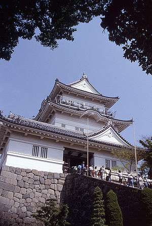
The area around present day Odawara has been settled since prehistoric times, and archaeological evidence indicates that the area had a high population density in the Jomon period. From the Ritsuryō system of the Nara period, the area became part of Ashigarashimo District of Sagami Province. It was divided into shōen during the Heian period, mostly controlled by the Hatano clan and its various branches. During the Gempei War between the Heike clan and Minamoto no Yoritomo, the Battle of Ishibashiyama was fought near present-day Odawara. During the Sengoku period, Odawara developed as a castle town and capital of the domains of the late Hōjō clan, which covered most of the Kantō region. The Hōjō were defeated by Toyotomi Hideyoshi in the Battle of Odawara in 1590, despite the impregnable reputation of Odawara Castle, and the territory came under the control of Tokugawa Ieyasu.
Under the Tokugawa shogunate, Odawara was the center of Odawara Domain, a feudal han ruled by a succession of daimyō. The castle town prospered as Odawara-juku, a post station on the Tōkaidō highway connecting Edo with Kyoto.
After the Meiji Restoration, Odawara Domain briefly became Odawara Prefecture, which was merged with the short-lived Ashigara Prefecture before joining Kanagawa Prefecture in 1876. During this period, the center of economic and political life in Kanagawa shifted to Yokohama, and Odawara suffered a strong decline in population, which was made more severe when the original route of the Tōkaidō Main Line bypassed the city in favor of the more northerly route via Gotemba.
The epicenter of the Great Kantō earthquake in 1923 was deep beneath Izu Ōshima Island in Sagami Bay. It devastated Tokyo, the port city of Yokohama, surrounding prefectures of Chiba, Kanagawa, and Shizuoka Prefectures, and caused widespread damage throughout the Kantō region. Ninety percent of the buildings in Odawara collapsed immediately, and fires burned the rubble along with anything else left standing.[1]
Odawara regained some measure of prosperity with the opening of the Tanna Tunnel in 1934, which brought the main routing of the Tōkaidō Main Line through the city. Odawara was raised from the status of town to city on December 20, 1940. On August 15, 1945, Odawara was the last city in Japan to be bombed by Allied aircraft during World War II. On November 1, 2000 Odawara exceeded 200,000 in population and was proclaimed a special ordinance city with increased autonomy from the central government.
Economy
Odawara is a major commercial center for western Kanagawa Prefecture. Agriculture and commercial fishing play a relatively minor role in the local economy. Manufacturing includes light industry, chemicals, pharmaceuticals, and food processing. Odawara is also a bedroom community for Yokohama and Tokyo.
Companies headquartered in Odawara include:
- Meganesuper Co., Ltd.
- Wako Pure Chemical Industries, Ltd
- Odawara Auto Machine MFG. Co., Ltd.
- Odakyu Sharyo Kogyo Co Ltd
- Odakyu Hakone Holdings Co., Ltd.
- Hakone Tozan Railway
- Sagami Trust Bank
- Nippon Injector Corporation
Transportation
Railway
- JR Central - Tōkaidō Shinkansen
- JR Central - Gotemba Line
- JR East - Tōkaidō Main Line
- Kōzu - Kamonomiya - Odawara - Hayakawa - Nebukawa
- Odakyu Electric Railway - Odakyu Odawara Line
- Hakone Tozan Railway - Hakone Tozan Line
- Izuhakone Railway - Daiyūzan Line
- Odawara - Midorichō - Isaida - Gohyakurakan - Anabe - Iidaoka - Sagami-Numata
Highway
- Odawara-Atsugi Road
- Japan National Route 1, to Tokyo or Kyoto
- Japan National Route 135, to Shimoda
- Japan National Route 138, to Fujiyoshida
- Japan National Route 255, to Hadano
- Japan National Route 271, to Atsugi (toll)
Bus
- Bus service to Izu Peninsula
Area attractions
Besides Odawara Castle, Odawara is a major transit point for the Hakone hot springs resort area and the sightseeing locations of the Fuji-Hakone-Izu National Park. Within the city itself, the Yugawara area is also a well-known hot spring resort.
Enoura, a coastal area of Odawara known for its pristine sea, has an abundance of kumamomi, a type of fish which prefers clear and clean water. Sea turtles are also sometimes present there. Because of the clear water and plentiful undersea life, many people come to Enoura for scuba diving.
Traditionally, Odawara is known for its production of kamaboko processed fish, stockfish, umeboshi salted plums and traditional herbal medicines.
Sister city relations
 - Nikko, Tochigi, since December 19, 1980
- - Kishiwada, Osaka, since June 26, 1968
 - Chula Vista, California, USA, since November 8, 1981
 - Manly, New South Wales, Australia (friendship city), since 1991
 - Shenzhen, Guangdong, China, since February 4, 1993
Notable people from Odawara
- Kai Atō - actor
- Yōhei Kōno - politician
- Ninomiya Sontoku - Edo period economist and philosopher
- Rumina Sato - mixed martial arts fighter
- Kitamura Tokoku - author
- Yoshiyuki Tomino - anime movie director
- Baku Yumemakura - science fiction author
Notes
References
- Hammer, Joshua. (2006). Yokohama Burning: The Deadly 1923 Earthquake and Fire that Helped Forge the Path to World War II. New York: Simon & Schuster. ISBN 978-0-7432-6465-5 (cloth)
External links
| Wikivoyage has a travel guide for Odawara. |
| Wikimedia Commons has media related to Odawara, Kanagawa. |
| Wards of Yokohama | ||
|---|---|---|
| Wards of Kawasaki | ||
| Wards of Sagamihara | ||
| Core city | ||
| Special cities | ||
| Cities | ||
| Aikō District | ||
| Ashigarakami District | ||
| Ashigarashimo District | ||
| Kōza District | ||
| Miura District | ||
| Naka District | ||