Iultinsky District
| Iultinsky District Иультинский район (Russian) Ивылтин район (Chukchi) | |
|---|---|
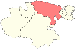 Location of Iultinsky District in Chukotka Autonomous Okrug | |
| Coordinates: 66°40′N 179°00′E / 66.667°N 179.000°ECoordinates: 66°40′N 179°00′E / 66.667°N 179.000°E | |
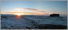
 View of southern Iultinsky District | |
 | |
|
| |
| Location | |
| Country | Russia |
| Federal subject | Chukotka Autonomous Okrug[1] |
| Administrative structure (as of June 2012) | |
| Administrative center | urban-type settlement of Egvekinot[1] |
| Inhabited localities:[2] | |
| Urban-type settlements[3] | 3 |
| Rural localities | 8 |
| Municipal structure (as of October 2010) | |
| Municipally incorporated as | Iultinsky Municipal District[4] |
| Municipal divisions:[4] | |
| Urban settlements | 2 |
| Rural settlements | 5 |
| Local government: | |
| Head of Administration[5] | Alexander Maximov[5] |
| Statistics | |
| Area (municipal district) | 134,600 km2 (52,000 sq mi)[6] |
| Population (2010 Census) | 4,329 inhabitants[7] |
| • Urban | 64.4% |
| • Rural | 35.6% |
| Population (January 2016 est.) | 4,814 inhabitants[8] |
| Density | 0.03/km2 (0.078/sq mi)[9] |
| Time zone | PETT (UTC+12:00)[10] |
| Established | December 2, 1953[6] |
| Official website | |
| Iultinsky District on WikiCommons | |
Iultinsky District (Russian: Иу́льтинский райо́н; Chukchi: Ивылтин район) is an administrative[1] and municipal[4] district (raion), one of the six in Chukotka Autonomous Okrug, Russia. It is located in the northeast of the autonomous okrug and borders with the Chukchi Sea in the north, Providensky District in the east, Gulf of Anadyr in the southeast, and with Anadyrsky District in the southwest. The area of the district is 134,600 square kilometers (52,000 sq mi).[6] Its administrative center is the urban locality (an urban-type settlement) of Egvekinot.[1] Population: 4,329 (2010 Census);[7] 3,974 (2002 Census);[11] 15,689 (1989 Census).[12] The population of Egvekinot accounts for 64.4% of the district's total population.[7]
The territory of the modern district has been populated since the Paleolithic age, though indigenous people are outnumbered by ethnic Russians by over three to one. The district was once a major center for mining tin and tungsten at Iultin, with the infrastructure built by gulag prisoners, but these mines have proved uneconomical in recent years and closed with their associated settlements abandoned.
Geography

Iultinsky District covers the northeastern part of the Chukchi Peninsula, except for its easternmost part, and touches two oceans. In the north, the district borders the Chukchi Sea, a bleak environment that is ice-bound for nine months of the year and where storms can produce waves several meters high lashing the coast.[13] To the south is the administrative center and small port of Egvekinot, located on the Kresta Bay. To the south of the Kresta Bay it reaches almost to the Anadyrsky Liman.
The central part of the district is quite mountainous. The northwest is drained by the Amguema River. This valley is a key resource for the part of the population that does not live by the sea and contains the only significant stretch of road in the district, running from Egvekinot, through the indigenous locality of Amguema, to the now defunct mining settlement of Iultin near the Arctic.[14] Other populated places in the district are only reachable either by sea or by helicopter.
History
Prehistory
It is thought that the area of what is now Iultinsky District was where the first people settled in Chukotka during the Paleolithic Age. Archaeological excavations have uncovered stone age camps and tools along the banks of both the Kymynanonvyaam and Maravaam Rivers.[13]
A greater number of camps has been unearthed dating from the Neolithic Period along almost all the significant rivers in the district.[13] Further excavations around Vankarem, Nutepelmen, and Uelkal indicate that there was a change in hunting practices during the 3rd millennium BCE as the native people began not only to follow migrating animals in the tundra, but also to hunt animals at sea. The locations of the archeological discoveries have established that the sea-fishing communities have been in existence in their current locations for a considerable period of time.[13]
17th–18th centuries
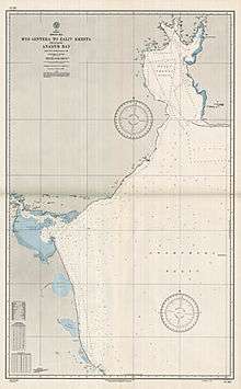
After Semyon Dezhnyov and his Cossack companions had established Anadyrsk in the 17th century, they began to explore the surrounding area and discovered the Kresta Bay in 1660, although it was not mapped properly until it was visited by Vitus Bering seventy years later.[13]
20th century
The district was founded on December 2, 1953.[6] The economy on this territory received a major boost following the discovery in the 1930s of significant deposits of tin and tungsten in Mount Iultin. This discovery resulted in the creation of the settlement of Iultin. Initially the settlement was kept supplied by a convoy of tractors, but it was difficult to make significant progress and so to ensure the settlement could continue to be supplied, a road was built linking Egvekinot, Amguema, and Iultin.[13]
During World War II, the territory played an important role in the Soviet supply chain, providing the eastern end of the Uelkal-Krasnoyarsk air route, used by Russia for the delivery of the Lend-Lease planes provide by the United States.[13]
Following the end of World War II, Dalstroy used forced labor to build a port to help supply the mine, and in 1946, the MV Sovetskaya Latviya, one of a fleet of ships used by Dalstroy to transport prisoners to the Kolyma gulag,[15] landed in the Kresta Bay to begin construction. Extreme conditions meant that, as in the construction of the Road of Bones, many prisoners died working and were buried where they fell and incorporated into the foundations of the port. Such bodies are still discovered during the spring thaw each year.[13]
In order to provide the necessary power to the mines at Iultin, two power stations—one diesel, one steam-powered—were constructed in Ozyorny[13] (now a microdistrict of Egvekinot); however, in recent years, mining in the region has proved impractical and the mines at Iultin were closed and the settlement abandoned, with the population moving to Egvekinot.[13]
Mergers
Before May 2008, Iultinsky Administrative District was municipally incorporated as Iultinsky Municipal District. In May 2008, Iultinsky and Shmidtovsky Municipal Districts were merged, forming an enlarged Vostochny Municipal District.[16] This change, however, did not affect the administrative aspect of these districts. Both Iultinsky and Shmidtovsky Administrative Districts continued to exist separately.
In October 2008, the law mandating the change was amended and the name Vostochny was discarded with the combined municipal district being renamed Iultinsky Municipal District. Shmidtovsky Administrative District was merged into Iultinsky Administrative District effective June 13, 2011.[17]
Demographics
The population consists mainly of Russians, although Chukchi, the dominant native people in the district[14] and other indigenous peoples such as Inuit[13] make up about 24% of the total population. The district is bisected by both the Arctic Circle and the line of the 180° longitude.
Economy

The main center of economic activity is around Egvekinot and its Ozyorny Microdistrict, a former rural locality now abolished and merged with Egvekinot. This settlement contains the main sea port, a hydroelectric power plant, and the district's principal airport, with Chukotavia providing air service to all major airports within the autonomous okrug.
Outside of the main urban area of Egvekinot, the economy is driven mainly by either mineral extraction (the area is rich in pewter and wolframite as well as coal), traditional indigenous reindeer herding or sea-based hunting, with Chukchi farming centers such as Amguema, Vankarem, and Konergino holding nearly 25,000 head of reindeer in 2005. One of the settlements where marine hunting is the main economic driver, Uelkal, is the most westerly Eskimo settlement in the world.
Transportation
In addition to the airports, Iultinsky District also contains the longest road in Chukotka, which goes from Egvekinot to Iultin through indigenous settlements such as Amguema. There are also a number of winter and tractor roads which branch off from the main Iultinskaya Road serving settlements such as Svetly and Vostochny, as well as some of the geological and mining camps in the district.
Administrative and municipal status

Within the framework of administrative divisions, Iultinsky District is one of the six in the autonomous okrug.[1] The urban-type settlement of Egvekinot serves as its administrative center.[1] The district does not have any lower-level administrative divisions and has administrative jurisdiction over three urban-type settlements and eight rural localities, consisting of all seven of the inhabited localities listed below in the "Inhabited localities" section and the rural locality of Billings.
As a municipal division, the district is incorporated as Iultinsky Municipal District and is divided into two urban settlements and five rural settlements.[4] The rural locality of Billings, which is administratively a part of Iultinsky District, is, however, municipally a part of Chaunsky Municipal District.
Inhabited localities
| Urban settlements | Population | Male | Female | Inhabited localities in jurisdiction |
|---|---|---|---|---|
| Egvekinot (Эгвекинот) |
2790 | 1364 (48.9%) | 1426 (51.1%) |
|
| Mys Shmidta (Мыс Шмидта) |
492 | 284 (57.7%) | 208 (42.3%) | |
| Rural settlements | Population | Male | Female | Rural localities in jurisdiction* |
| Amguema (Амгуэма) |
531 | 279 (52.5%) | 252 (47.5%) | |
| Konergino (Конергино) |
424 | 216 (50.9%) | 208 (49.1%) |
|
| Ryrkaypiy (Рыркайпий) |
766 | 388 (50.7%) | 378 (49.3%) |
|
| Uelkal (Уэлькаль) |
243 | 125 (51.4%) | 118 (48.6%) |
|
| Vankarem (Ванкарем) |
184 | 98 (53.3%) | 86 (46.7%) |
|
| Inhabited localities in the inter-settlement territory | ||||
| ||||
| Inhabited localities being liquidated | ||||
| ||||
Divisional source:[4]
Population source:[7]
*Administrative centers are shown in bold
References
Notes
- 1 2 3 4 5 6 Law #33-OZ
- ↑ Directive #517-rp
- ↑ The count of urban-type settlements may include the work settlements, the resort settlements, the suburban (dacha) settlements, as well as urban-type settlements proper.
- 1 2 3 4 5 Law #149-OZ
- 1 2 Official website of Iultinsky District. Head of Administration of Iultinsky District (Russian)
- 1 2 3 4 Official website of Iultinsky District. About the district (Russian)
- 1 2 3 4 Russian Federal State Statistics Service (2011). "Всероссийская перепись населения 2010 года. Том 1" [2010 All-Russian Population Census, vol. 1]. Всероссийская перепись населения 2010 года (2010 All-Russia Population Census) (in Russian). Federal State Statistics Service. Retrieved June 29, 2012.
- ↑ Chukotka Autonomous Okrug Territorial Branch of the Federal State Statistics Service. Численность постоянного населения Чукотского автономного округа по муниципальным образованиям на 1 января 2016 года (Russian)
- ↑ The value of density was calculated automatically by dividing the 2010 Census population by the area specified in the infobox. Please note that this value is only approximate as the area specified in the infobox does not necessarily correspond to the area of the entity proper or is reported for the same year as the population.
- ↑ Правительство Российской Федерации. Федеральный закон №107-ФЗ от 3 июня 2011 г. «Об исчислении времени», в ред. Федерального закона №271-ФЗ от 03 июля 2016 г. «О внесении изменений в Федеральный закон "Об исчислении времени"». Вступил в силу по истечении шестидесяти дней после дня официального опубликования (6 августа 2011 г.). Опубликован: "Российская газета", №120, 6 июня 2011 г. (Government of the Russian Federation. Federal Law #107-FZ of June 31, 2011 On Calculating Time, as amended by the Federal Law #271-FZ of July 03, 2016 On Amending Federal Law "On Calculating Time". Effective as of after sixty days following the day of the official publication.).
- ↑ Russian Federal State Statistics Service (May 21, 2004). "Численность населения России, субъектов Российской Федерации в составе федеральных округов, районов, городских поселений, сельских населённых пунктов – районных центров и сельских населённых пунктов с населением 3 тысячи и более человек" [Population of Russia, Its Federal Districts, Federal Subjects, Districts, Urban Localities, Rural Localities—Administrative Centers, and Rural Localities with Population of Over 3,000] (XLS). Всероссийская перепись населения 2002 года [All-Russia Population Census of 2002] (in Russian). Retrieved August 9, 2014.
- ↑ Demoscope Weekly (1989). "Всесоюзная перепись населения 1989 г. Численность наличного населения союзных и автономных республик, автономных областей и округов, краёв, областей, районов, городских поселений и сёл-райцентров" [All Union Population Census of 1989: Present Population of Union and Autonomous Republics, Autonomous Oblasts and Okrugs, Krais, Oblasts, Districts, Urban Settlements, and Villages Serving as District Administrative Centers]. Всесоюзная перепись населения 1989 года [All-Union Population Census of 1989] (in Russian). Институт демографии Национального исследовательского университета: Высшая школа экономики [Institute of Demography at the National Research University: Higher School of Economics]. Retrieved August 9, 2014.
- 1 2 3 4 5 6 7 8 9 10 11 Fute, pp. 122ff
- 1 2 Norwegian Polar Institute. Indigenous Peoples of the north of the Russian Federation, Map 3.6
- ↑ Bollinger, Martin J., Stalin's Slave Ships: Kolyma, the Gulag fleet, and the role of the West, Praeger, 2003, ISBN 0-275-98100-2
- ↑ Law #40-OZ
- ↑ Law #44-OZ
Sources
- Дума Чукотского автономного округа. Закон №33-ОЗ от 30 июня 1998 г. «Об административно-территориальном устройстве Чукотского автономного округа», в ред. Закона №55-ОЗ от 9 июня 2012 г. «О внесении изменений в Закон Чукотского автономного округа "Об административно-территориальном устройстве Чукотского автономного округа"». Вступил в силу по истечении десяти дней со дня его официального опубликования. Опубликован: "Ведомости", №7 (28), 14 мая 1999 г. (Duma of Chukotka Autonomous Okrug. Law #33-OZ of June 30, 1998 On the Administrative-Territorial Structure of Chukotka Autonomous Okrug, as amended by the Law #55-OZ of June 9, 2012 On Amending the Law of Chukotka Autonomous Okrug "On the Administrative-Territorial Structure of Chukotka Autonomous Okrug". Effective as of after ten days from the day of the official publication.).
- Правительство Чукотского автономного округа. Распоряжение №517-рп от 30 декабря 2008 г. «Об утверждении реестра административно-территориальных и территориальных образований Чукотского автономного округа», в ред. Распоряжения №323-рп от 27 июня 2011 г. «О внесении изменений в Распоряжение Правительства Чукотского автономного округа от 30 декабря 2008 года №517-рп». Опубликован: База данных "Консультант-плюс". (Government of Chukotka Autonomous Okrug. Directive #517-rp of December 30, 2008 On the Adoption of the Registry of the Administrative-Territorial and Territorial Formations of Chukotka Autonomous Okrug, as amended by the Directive #323-rp of June 27, 2011 On Amending the Government of Chukotka Autonomous Okrug Directive No. 517-rp of December 30, 2008. ).
- Дума Чукотского автономного округа. Закон №149-ОЗ от 24 ноября 2008 г. «О статусе, границах и административных центрах муниципальных образований на территории Иультинского муниципального района Чукотского автономного округа», в ред. Закона №85-ОЗ от 20 октября 2010 г «Об упразднении сельского поселения Нутэпэльмен Иультинского муниципального района Чукотского автономного округа и о внесении изменений в отдельные законодательные акты Чукотского автономного округа». Вступил в силу через десять дней со дня официального опубликования. Опубликован: "Ведомости", №46/1 (373/1), 28 ноября 2008 г. (Duma of Chukotka Autonomous Okrug. Law #149-OZ of November 24, 2008 On the Status, Borders, and Administrative Centers of the Municipal Formations on the Territory of Iultinsky Municipal District of Chukotka Autonomous Okrug, as amended by the Law #85-OZ of October 20, 2010 On the Abolition of Nutepelmen Rural Settlement of Iultinsky Municipal District of Chukotka Autonomous Okrug and on Amending Several Legislative Acts of Chukotka Autonomous Okrug. Effective as of the day ten days after the official publication date.).
- Дума Чукотского автономного округа. Закон №40-ОЗ от 30 мая 2008 г. «О преобразовании муниципальных образований Иультинский муниципальный район и Шмидтовский муниципальный район и о внесении изменений в отдельные законодательные акты Чукотского автономного округа», в ред. Закона №85-ОЗ от 20 октября 2010 г «Об упразднении сельского поселения Нутэпэльмен Иультинского муниципального района Чукотского автономного округа и о внесении изменений в отдельные законодательные акты Чукотского автономного округа». Вступил в силу через десять дней со дня официального опубликования. Опубликован: "Ведомости", №22/1 (349/1), 6 июня 2008 г. (Duma of Chukotka Autonomous Okrug. Law #40-OZ of May 30, 2008 On the Transformation of the Municipal Formations of Iultinsky Municipal District and Shmidtovsky Municipal District an on Amending Several Legislative Acts of Chukotka Autonomous Okrug, as amended by the Law #85-OZ of October 20, 2010 On Abolishing of Nutepelmen Rural Settlement of Iultinsky Municipal District of Chukotka Autonomous Okrug and on Amending Several Legislative Acts of Chukotka Autonomous Okrug. Effective as of the day ten days after the official publication date.).
- Дума Чукотского автономного округа. Закон №44-ОЗ от 26 мая 2011 г. «О преобразовании некоторых административно-территориальных образований в Чукотском автономном округе и внесении изменений в Закон Чукотского автономного округа "Об административно-территориальном устройстве Чукотского автономного округа"». Вступил в силу через 10 дней со дня официального опубликования. Опубликован: "Ведомости", №21(502), 3 июня 2011 г. (Duma of Chukotka Autonomous Okrug. Law #44-OZ of May 26, 2011 On the Transformation of Several Administrative-Territorial Entities in Chukotka Autonomous Okrug and on Amending the Law of Chukotka Autonomous Okrug "On the Administrative-Territorial Division of Chukotka Autonomous Okrug". Effective as of the day which is 10 days after the day of the official publication.).
External links
- Official website of Iultinsky District (Russian)
- Short film in abandoned mining settlement of Iultin
- Short film on the transport difficulties faced in Iultinsky District
Administrative center: Anadyr | ||
| Cities and towns | ||
| Urban-type settlements | ||
| Administrative districts (raions) | ||