Shakhtyorsky, Chukotka Autonomous Okrug
| Shakhtyorsky (English) Шахтёрский (Russian) | |
|---|---|
|
- Urban-type settlement[1] - (abolished) | |
|
| |
.svg.png) Location of Chukotka Autonomous Okrug in Russia | |
 Shakhtyorsky | |
|
| |
| Administrative status (as of 6 October 2009) | |
| Country | Russia |
| Federal subject | Chukotka Autonomous Okrug[1] |
| Administrative district | Anadyrsky District[1] |
| Municipal status (as of October 2009) | |
| Municipal district | Anadyrsky District |
| Statistics | |
| Population (2002 Census) | 328 inhabitants[1] |
| Population (June 2005 est.) | 93 inhabitants[2] |
| Time zone | PETT (UTC+12:00)[3] |
| Previous names | Kombinat (until 1950s)[4] |
| Abolished | 1998[5] |
| Postal code(s)[6] | 689520 |
Shakhtyorsky (Russian: Шахтёрский), is an urban-type settlement in Anadyrsky District of Chukotka Autonomous Okrug, Russia. As of 2008, it is in the process of being abolished due to it no longer being considered economically viable to continue mining in the area.[5][7] Population: 328 (2002 Census);[1] 2,968 (1989 Census).[8] As a result of the cessation of mining activities, the population of the settlement has continued to decline. By 2005, an environmental impact report prepared for the Kupol Gold Project indicated that the population of Shakhtyorsky had fallen to just 93 people.[2]
Geography
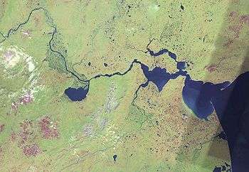
The settlement is located on the northern shores of the Anardyrsky Liman where the waters of the Anadyr, Kanchalan and Velikaya meet creating an estuary. It is located on the northern side of the isthmus, a few miles north west of Ugolnye Kopi and across the water from Anadyr (town), where the three main parts of the estuary, the northern series of lakes, the southern lake and the big lagoon on the east join.
The settlement is served by Ugolny Airport.
History
Shakhtyorsky owes its existence to the presence of both coal and fish in the area and because of that it used to be called Kombinat (lit. Industrial Complex) in the 1950s and 1960s and was the site of the first airport in the District which was constructed in 1930. The settlement used to alternate with Ugolnye Kopi as the administrative centre of the district until 1997 when the centre was finally fixed at Ugolnye Kopi.[4]
The mines were declared unprofitable and that there was no possibility of developing any other form of economy in 1999 and the settlement was closed along with a number of others in Chukotka.[9] The Russian government guaranteed funds to transport non-working pensioners and the unemployed in liquidated settlements including Shakhtyorsky from Chukotka to other parts of Russia.[9] The Ministry of railways was obliged to lease containers for the transportation of the migrants' goods to the Chukotkan administration and ensure that they were delivered to the various settlements.[9]
Transport
Shakltyorsky is connected to Ugolnye Kopi and Anadyr Ugolny Airport by a small road system as well as to the now-abandoned settlements of Chetvertiy, Zolotoy and Vtoroy however, it is separated from Anadyr by the Anadyrsky Liman,[10] which is only accessible by ferry. there is also a small network of roads within the settlement including:[11]
- Улицa Гагарина (Ulitsa Gagarina, lit. Gagarin Street)
- Улицa Геологов (Ulitsa Geologov, lit. Geologists' Street)
- Улицa Елкова (Ulitsa Yelkova)
- Улицa Комсомольская (Ulitsa Komsomolskaya, lit. Komsomol Street)
- Улицa Набережная (Ulitsa Naberezhnaya, lit. Quay Street)
- Улицa Нефтяников (Ulitsa Neftyanikov, lit. Oil Workers' Street)
- Улицa Почтовая (Ulitsa Pochtovaya, lit. Postal Street)
- Улицa Радиоцентр (Ulitsa Radiotsentr, lit. Central Radio Street)
- Улицa Титова (Ulitsa Titova)
- Улицa Тундровая (Ulitsa Tundrovaya, lit. Tundra Street)
- Улицa Центральная (Ulitsa Tsentralnaya, lit. Central Street)
- Улицa Чкалова (Ulitsa Chkalova)
- Улицa Школьная (Ulitsa Shkolnaya, lit. School Street)
Climate
Shakhtyorsky has a Tundra climate (ET)[12] because the warmest month has an average temperature between 0 °C (32 °F) and 10 °C (50 °F).
| Climate data for Shakhtyorsky, Chukotka Autonomous Okrug | |||||||||||||
|---|---|---|---|---|---|---|---|---|---|---|---|---|---|
| Month | Jan | Feb | Mar | Apr | May | Jun | Jul | Aug | Sep | Oct | Nov | Dec | Year |
| Record high °C (°F) | 1.2 (34.2) |
2.2 (36) |
5.1 (41.2) |
5 (41) |
14 (57) |
26 (79) |
28 (82) |
25.6 (78.1) |
23.4 (74.1) |
10.8 (51.4) |
5 (41) |
3.6 (38.5) |
28 (82) |
| Average high °C (°F) | −19.7 (−3.5) |
−17.4 (0.7) |
−14.5 (5.9) |
−8.2 (17.2) |
2 (36) |
11.2 (52.2) |
15.8 (60.4) |
13.7 (56.7) |
7.9 (46.2) |
−1.8 (28.8) |
−8.9 (16) |
−16.6 (2.1) |
−3 (27) |
| Average low °C (°F) | −26.6 (−15.9) |
−24.6 (−12.3) |
−21.8 (−7.2) |
−15.7 (3.7) |
−3.8 (25.2) |
3.8 (38.8) |
8.8 (47.8) |
7.5 (45.5) |
2.1 (35.8) |
−7.1 (19.2) |
−15.7 (3.7) |
−23.4 (−10.1) |
−9.7 (14.5) |
| Record low °C (°F) | −44 (−47) |
−44.1 (−47.4) |
−39 (−38) |
−32.5 (−26.5) |
−22.5 (−8.5) |
−5.7 (21.7) |
−12.1 (10.2) |
−5 (23) |
−10.4 (13.3) |
−25.3 (−13.5) |
−35.8 (−32.4) |
−40 (−40) |
−44.1 (−47.4) |
| Average rainfall mm (inches) | 41.7 (1.642) |
44.8 (1.764) |
32.7 (1.287) |
24.5 (0.965) |
16.1 (0.634) |
24.9 (0.98) |
42.2 (1.661) |
44.9 (1.768) |
37.1 (1.461) |
28.5 (1.122) |
38.7 (1.524) |
32.3 (1.272) |
408.4 (16.079) |
| Average snowy days | 15 | 14 | 13 | 15 | 14 | 1 | 0 | 0 | 3 | 16 | 18 | 15 | 124 |
| Source: [13] | |||||||||||||
See also
References
Notes
- 1 2 3 4 5 Russian Federal State Statistics Service (May 21, 2004). "Численность населения России, субъектов Российской Федерации в составе федеральных округов, районов, городских поселений, сельских населённых пунктов – районных центров и сельских населённых пунктов с населением 3 тысячи и более человек" [Population of Russia, Its Federal Districts, Federal Subjects, Districts, Urban Localities, Rural Localities—Administrative Centers, and Rural Localities with Population of Over 3,000] (XLS). Всероссийская перепись населения 2002 года [All-Russia Population Census of 2002] (in Russian). Retrieved August 9, 2014.
- 1 2 Bema Gold Corporation, p.87
- ↑ Правительство Российской Федерации. Федеральный закон №107-ФЗ от 3 июня 2011 г. «Об исчислении времени», в ред. Федерального закона №271-ФЗ от 03 июля 2016 г. «О внесении изменений в Федеральный закон "Об исчислении времени"». Вступил в силу по истечении шестидесяти дней после дня официального опубликования (6 августа 2011 г.). Опубликован: "Российская газета", №120, 6 июня 2011 г. (Government of the Russian Federation. Federal Law #107-FZ of June 31, 2011 On Calculating Time, as amended by the Federal Law #271-FZ of July 03, 2016 On Amending Federal Law "On Calculating Time". Effective as of after sixty days following the day of the official publication.).
- 1 2 Strogoff, p.89
- 1 2 Shakhtyorsky - www.dead-cities.ru (Russian)
- ↑ Почта России. Информационно-вычислительный центр ОАСУ РПО. (Russian Post). Поиск объектов почтовой связи (Postal Objects Search) (Russian)
- ↑ Law #33 Article 14.2
- ↑ Demoscope Weekly (1989). "Всесоюзная перепись населения 1989 г. Численность наличного населения союзных и автономных республик, автономных областей и округов, краёв, областей, районов, городских поселений и сёл-райцентров" [All Union Population Census of 1989: Present Population of Union and Autonomous Republics, Autonomous Oblasts and Okrugs, Krais, Oblasts, Districts, Urban Settlements, and Villages Serving as District Administrative Centers]. Всесоюзная перепись населения 1989 года [All-Union Population Census of 1989] (in Russian). Институт демографии Национального исследовательского университета: Высшая школа экономики [Institute of Demography at the National Research University: Higher School of Economics]. Retrieved August 9, 2014.
- 1 2 3 Постановление Правительства РФ от 2 февраля 1998 г. N 128 О мерах социальной защиты населения ликвидируемых поселков золотодобытчиков в Чукотском автономном округe (Russian Federation Government resolution dated February 2, 1998 No. 128 on measures of social protection of the population of liquidating estates gold miners in the Chukotka Autonomous Okrug "Russian Federation Government resolution dated February 2, 1998 No. 128 on measures of social protection of the population of liquidating estates gold miners in the Chukotka Autonomous Okrug).
- ↑ Map Q-59-60 at Vlasenko.net
- ↑ Shaktyorsky - Anadyrsky District at Pochtovik Mail Delivery Company
- ↑ McKnight and Hess, pp. 235−7
- ↑ "Weather Averages for Shakhtyorsky, Chuokotka Autonomous Okrug from meoweather.com". meoweather.com. Retrieved October 8, 2012.
Sources
- Bema Gold Corporation, Environmental Impact Assessment, Kupol Gold Project, Far East Russia June 2005.
- Дума Чукотского автономного округа. Закон №33-ОЗ от 30 июня 1998 г. «Об административно-территориальном устройстве Чукотского автономного округа», в ред. Закона №138-ОЗ от 25 октября 2007 г. (Duma of Chukotka Autonomous Okrug. Law #33-OZ of June 30, 1998 On Administrative and Territorial Structure of Chukotka Autonomous Okrug, as amended by the Law #138-OZ of October 25, 2007. ). (Russian)
- McKnight, Tom L; Hess, Darrel (2000). "Climate Zones and Types". Physical Geography: A Landscape Appreciation. Upper Saddle River, NJ: Prentice Hall. ISBN 0-13-020263-0.
- M Strogoff, P-C Brochet, and D. Auzias Petit Futé: Chukotka (2006). "Avant-Garde" Publishing House.
External links
- Shakhtyorsky photo gallery (Russian)
- Panorama of Shakhtyorsky (Russian)
- More photos of Shakhtyorsky (Russian)
Administrative center: Anadyr | ||
| Cities and towns | ||
| Urban-type settlements | ||
| Administrative districts (raions) | ||