Irymple, Victoria
| Irymple Victoria | |||||||||||||
|---|---|---|---|---|---|---|---|---|---|---|---|---|---|
 The Calder Highway, passing through Irymple. Approaching the level crossing on the Mildura Line. | |||||||||||||
 Irymple | |||||||||||||
| Coordinates | 34°14′0″S 142°10′0″E / 34.23333°S 142.16667°ECoordinates: 34°14′0″S 142°10′0″E / 34.23333°S 142.16667°E | ||||||||||||
| Population | 5,740 (2006 census)[1] | ||||||||||||
| Postcode(s) | 3498 | ||||||||||||
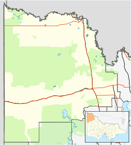
| Location | |||||||||||||
| LGA(s) | Rural City of Mildura | ||||||||||||
| State electorate(s) | Mildura | ||||||||||||
| Federal Division(s) | Mallee | ||||||||||||
| |||||||||||||
Irymple (/ˈaɪərɪmpəl/ EYE-rim-pəl) is a town in the state of Victoria in Australia. Located in the region of Sunraysia in the far North-West Victoria, Irymple is 6 km south of Mildura and 550 km northwest of Melbourne. At the 2006 census, Irymple and the surrounding area had a population of 5,740.[1]
The township was established soon after Mildura, the Post Office opening on 17 February 1892.[2]
Features
The township has one kindergarten (Irymple Kindergarten), two primary schools (Irymple Primary School and Irymple South Primary School), one secondary school (Irymple Secondary College, years 7-10) and two P-10 schools (the Baptist Mildura Christian College and the Adventist Henderson College).
Irymple has a football and netball club competing in the Sunraysia Football Netball League,[3] a soccer club, a lawn bowls club, a bocce club, a swimming club and a basketball association, all of which have home grounds located in the township.
References
- 1 2 Australian Bureau of Statistics (25 October 2007). "Irymple (State Suburb)". 2006 Census QuickStats. Retrieved 4 August 2007.
- ↑ Premier Postal History, Post Office List, retrieved 11 April 2008
- ↑ "Sunraysia Football & Netball League". Fox Sports Pulse. Retrieved 16 August 2016.