Inka Wasi (Bolivia)
This article is about the mountain in the Chuquisaca Department, Bolivia. For other uses, see Inka Wasi.
| Inka Wasi | |
|---|---|
 Inka Wasi Location within Bolivia | |
| Highest point | |
| Elevation | 3,146 m (10,322 ft) [1] |
| Coordinates | 19°44′12″S 64°40′26″W / 19.73667°S 64.67389°WCoordinates: 19°44′12″S 64°40′26″W / 19.73667°S 64.67389°W |
| Geography | |
| Location |
Bolivia, Chuquisaca Department |
| Parent range | Andes |
Inka Wasi (Quechua inka Inca, wasi house,[2] "Inca house", also spelled Inca Huasi) is a 3,146-metre-high (10,322 ft) mountain in the Bolivian Andes. It is located in the Chuquisaca Department, Azurduy Province, Tarvita Municipality. Inka Wasi lies southwest of Muyu Urqu and north of Pukara. The Laqha Mayu ("dark river") originates north of the mountain. Its waters flow to the Pillku Mayu (Quechua for "red river").[1][3]
References
Capital: Sucre | ||
| Provinces | 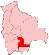 | |
| Municipalities and seats |
| |
This article is issued from Wikipedia - version of the 4/30/2016. The text is available under the Creative Commons Attribution/Share Alike but additional terms may apply for the media files.