Tomina Province
| Tomina Province | |
|---|---|
| Province | |
|
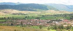
Padilla, the province capital | |
 Location of Tomina Province within Bolivia | |
| Coordinates: 19°30′0″S 64°15′0″W / 19.50000°S 64.25000°W | |
| Country |
|
| Department | Chuquisaca Department |
| Capital | Padilla |
| Government | |
| • Mayor | Constancio Salazar Padilla (2007) |
| Area | |
| • Total | 1,524 sq mi (3,947 km2) |
| Population (2001) | |
| • Total | 37,482 |
| • Density | 25/sq mi (9.5/km2) |
| • Ethnicities | Quechua |
Tomina is a province in the Chuquisaca Department in Bolivia. Its seat is Padilla.
Geography
Some of the highest mountains of the province are listed below:[1][2]
- Atuq Waqana
- Ch'utu Muqu
- Jatun Punta
- Kancha Q'asa
- Liwqiyuq Punta
- Mayu Tinku
- Palta Urqu
- Qallu Urqu
- Saqra Kimray
- Sirkani Punta
- Supay Q'asa
- Wayra Urqu
- Wisk'achayuq
- Yana Qaqa Punta
- Yana Yana
Subdivisions

Tomina Province is divided into five municipalities which are partly further subdivided into cantons.
| Section | Municipality | Inhabitants (2001) [3] | Seat | Inhabitants (2001) |
|---|---|---|---|---|
| 1st | Padilla Municipality | 12,562 | Padilla | 2,714 |
| 2nd | Tomina Municipality | 9,060 | Tomina | 983 |
| 3rd | Sopachuy Municipality | 7,241 | Sopachuy | 1,478 |
| 4th | Villa Alcalá Municipality | 4,034 | Villa Alcalá | 838 |
| 5th | El Villar Municipality | 4,585 | El Villar | 486 |
The people
The people are predominantly indigenous citizens of Quechuan descent.
| Ethnic group | Padilla Municipality (%) | Tomina Municipality (%) | Sopachuy Municipality (%) | Villa Alcalá Municipality (%) | El Villar Municipality (%) |
|---|---|---|---|---|---|
| Quechua | 55.1 | 83.8 | 84.5 | 29.9 | 55.2 |
| Aymara | 0.5 | 0.3 | 0.2 | 0.0 | 0.2 |
| Guaraní, Chiquitos, Moxos | 0.6 | 0.0 | 0.2 | 0.0 | 0.7 |
| Not indigenous | 43.5 | 15.8 | 147 | 68.5 | 43.3 |
| Other indigenous groups | 0.3 | 0.2 | 0.4 | 1.5 | 0.5 |
Ref.: obd.descentralizacion.gov.bo
Languages
The languages spoken in the province are mainly Spanish and Quechua. [4]
| Language | Padilla Municipality | Tomina Municipality | Sopachuy Municipality | Villa Alcalá Municipality | El Villar Municipality |
|---|---|---|---|---|---|
| Quechua | 2,181 | 7,831 | 6,261 | 1,167 | 1,264 |
| Aymara | 29 | 23 | 10 | 7 | 15 |
| Guaraní | 6 | 4 | 3 | 3 | 1 |
| Another native | 2 | 2 | 3 | 1 | 0 |
| Spanish | 11,585 | 4,418 | 3,003 | 3,576 | 4,190 |
| Foreign | 27 | 12 | 9 | 9 | 4 |
| Only native | 250 | 4,036 | 3,791 | 176 | 146 |
| Native and Spanish | 1,951 | 3,803 | 2,478 | 997 | 1,123 |
| Only Spanish | 9,635 | 616 | 526 | 2,579 | 3,067 |
Tourist attractions
Padilla Municipality is situated within the Iñao National Park and Integrated Management Natural Area. [5]
See also
References
- ↑ Bolivian IGM map 1:50,000 Hacienda Chunca Cancha 6635-II
- ↑ "Sopachuy". INE, Bolivia. Retrieved April 22, 2016.
- ↑ www.ine.gov.bo (Spanish)
- ↑ obd.descentralizacion.gov.bo
- ↑ www.lexivox.org
Capital: Sucre | ||
| Provinces | 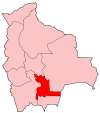 | |
| Municipalities and seats |
| |
Coordinates: 19°30′00″S 64°15′00″W / 19.500°S 64.250°W
This article is issued from Wikipedia - version of the 6/17/2016. The text is available under the Creative Commons Attribution/Share Alike but additional terms may apply for the media files.