Oropeza Province
| Oropeza Province | |
|---|---|
| Province | |
|
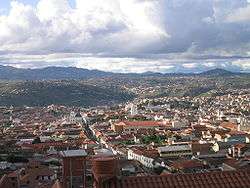
Sucre, the constitutional capital of Bolivia and the capital of the Oropeza Province | |
 Location of Oropeza Province within Bolivia | |
| Coordinates: 18°50′S 65°15′W / 18.833°S 65.250°W | |
| Country |
|
| Department | Chuquisaca Department |
| Capital | Sucre |
| Area | |
| • Total | 1,522 sq mi (3,943 km2) |
| Elevation | 7,000 ft (2,000 m) |
| Population (2001) | |
| • Total | 241,376 |
| • Density | 159/sq mi (61.2/km2) |
| • Ethnicities | Quechuas |
| Time zone | GMT -4 |
Oropeza is a province in the Chuquisaca Department, Bolivia. Its seat is Sucre which is also the constitutional capital of Bolivia and the capital of the Chuquisaca Department.
Geography
Some of the highest mountains of the province are listed below:[1][2][3][4]
- Alisu Punta
- Asna Kancha
- Chawayasqa
- Chullpa Urqu
- Chullpani
- Ch'aki Mayu
- Ch'usiqani
- Illimani
- Inti Rumi
- Jatun Pampa
- Jatun Q'asa
- Jatun Urqu
- Juch'uy Satari
- Katariri
- Kimsa Muqu
- Kimsa Ñuñu
- Kimsa T'ipa
- Misk'a Urqu
- Mulli Punta
- Mulli Urqu
- Parya Punta
- Pukara
- P'aqla Urqu
- Quchayuq
- Satari
- Tawayuq
- Tuqtu Q'asa
- Wallpa Q'asa
- Wayra Pata
- Wayrani Wayu
- Wichhu Qullu
- Wiru Wiru
Subdivision
The province is divided into three municipalities which are further subdivided into cantons.
| Section | Municipality | Inhabitants (2001) [5] | Seat | Inhabitants (2001) |
|---|---|---|---|---|
| Capital Municipality | Sucre Municipality | 214,913 | Sucre | 193,876 |
| 1st | Yotala Municipality | 9,497 | Yotala | 1,538 |
| 2nd | Poroma Municipality | 16,966 | Poroma | 486 |
The people
The people are predominantly indigenous citizens of Quechuan descent.
| Ethnic group | Sucre Municipality (%) | Yotala Municipality (%) | Poroma Municipality (%) |
|---|---|---|---|
| Quechua | 57.3 | 90.4 | 94.7 |
| Aymara | 2.3 | 0.8 | 0.9 |
| Guaraní, Chiquitos, Moxos | 1.4 | 0.2 | 0.1 |
| Not indigenous | 38.6 | 8.3 | 4.2 |
| Other indigenous groups | 0.4 | 0.3 | 0.1 |
Ref.: obd.descentralizacion.gov.bo
Languages
The languages spoken in the province are mainly Spanish and Quechua.
| Language | Sucre Municipality | Yotala Municipality | Poroma Municipality |
|---|---|---|---|
| Quechua | 116,053 | 8,197 | 15,554 |
| Aymara | 3,322 | 68 | 165 |
| Guaraní | 344 | 8 | 4 |
| Another native | 67 | 0 | 4 |
| Spanish | 183,231 | 5,587 | 4,620 |
| Foreign | 8,156 | 41 | 8 |
| Only native | 19,901 | 3,319 | 11,057 |
| Native and Spanish | 97,831 | 4,916 | 4,513 |
| Only Spanish | 85,497 | 673 | 107 |
Ref.: obd.descentralizacion.gov.bo
Places of interest

Cave paintings at Inka Mach'ay
The archaeological sites of Inka Mach'ay and Puma Mach'ay are situated within the province. Inka Mach'ay was declared a National Monument in 1958. [6]
See also
References
- ↑ Bolivia 1:50,000 Tasapampa 6536-III
- ↑ "Yotala". INE, Bolivia. Retrieved April 14, 2016.
- ↑ Bolivian IGM map 1:50,0000 Poroma 6538-III
- ↑ "Poroma". INE, Bolivia. Retrieved April 15, 2016.
- ↑ www.ine.gov.bo (Spanish)
- ↑ Archaeological parks in Bolivia
Capital: Sucre | ||
| Provinces | 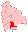 | |
| Municipalities and seats |
| |
This article is issued from Wikipedia - version of the 4/22/2016. The text is available under the Creative Commons Attribution/Share Alike but additional terms may apply for the media files.