IB-12 highway (Serbia)
| ||||
|---|---|---|---|---|
|
Државни пут IБ реда 12 Državni put IB reda 12 | ||||
 | ||||
| Route information | ||||
|
Part of | ||||
| Maintained by JP "Putevi Srbije" | ||||
| Length: | 276.837 km (172.019 mi) | |||
| Major junctions | ||||
| From: |
Subotica | |||
| To: |
Serbia-Romania border at Srpska Crnja | |||
| Location | ||||
| Districts: | North Bačka, West Bačka, South Bačka, Central Banat | |||
| Highway system | ||||
| ||||

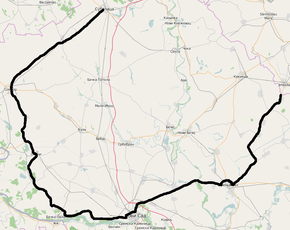
National/State Road 12, is an IB-class road in northern Serbia, connecting Subotica with Romania. It is located in Vojvodina.[1]
Before the new road categorization regulation given in 2013, the route wore the following names: M 17.1, M 18, P 101 and M 7 (before 2012) / 12, 28, 19, 102, 20, 11, and 108 (after 2012).[2][3]
The existing route is a main road with two traffic lanes. By the valid Space Plan of Republic of Serbia the road is not planned for upgrading to motorway, and is expected to be conditioned in its current state.[4]
Road section from Subotica to Sombor is a part of European route E662.
Sections
| Section number | Length (km) | Distance (km) | Section name |
|---|---|---|---|
| 01201 | 19.233 | 19.233 | Subotica (Sombor) - Bajmok |
| 01202 | 21.671 | 40.904 | Bajmok - Svetozar Miletić |
| 01203 | 12.709 | 53.613 | Svetozar Miletić - Sombor (Bezdan) |
| 01204 | 4.215 | 57.828 | Sombor (Bezdan) - Sombor (Apatin) (overlap with |
| 01205 | 2.518/0.099 | 60.346 | Sombor (Apatin) - Sombor (industrial zone) (overlap with |
| 01206 | 24.976/0.721 | 85.322 | Sombor (industrial zone) - Srpski Miletić |
| 01207 | 9.378 | 94.700 | Srpski Miletić - Odžaci (Kula) |
| 01208 | 13.592 | 108.292 | Odžaci (Kula) - Bač |
| 01209 | 22.142 | 130.434 | Bač - Bačka Palanka (bypass) |
| 01210 | 10.846/0.381 | 141.280 | Bačka Palanka (bypass) - Čelarevo |
| 01211 | 28.877/8.921 | 170.157 | Čelarevo - Novi Sad (Rumenka) |
| 01212 | 2.220/2.224 | 172.377 | Novi Sad (Rumenka) - Novi Sad (Sirig) |
| 01213 | 4.228/4.219 | 176.605 | Novi Sad (Sirig) - Novi Sad-east interchange |
| 01214 | 3.742/0.422 | 180.347 | Novi Sad-east interchange - Kać |
| 01215 | 13.330 | 193.677 | Kać - Žabalj (Šajkaš) |
| 01216 | 26.686/2.420 | 220.363 | Žabalj (Šajkaš) - Zrenjanin (Kikinda) |
| 01217 | 1.662/1.671 | 222.025 | Zrenjanin (Kikinda) - Zrenjanin (Ečka) (overlap with |
| 01218 | 2.410/2.108 | 224.435 | Zrenjanin (Ečka) - Zrenjanin (Sečanj) |
| 01219 | 14.636/2.253 | 239.071 | Zrenjanin (Sečanj) - Žitište |
| 01220 | 15.055 | 254.126 | Žitište - Banatsko Karađorđevo |
| 01221 | 8.292 | 262.418 | Banatsko Karađorđevo - Nova Crnja |
| 01222 | 4.414 | 266.832 | Nova Crnja - Vojvoda Stepa |
| 01223 | 10.005 | 276.837 | Vojvoda Stepa - Serbia-Romania border (Srpska Crnja) |
See also
References
- ↑ "Republic of Serbia - national road network" (PDF). Putevi Srbije (in Serbian).
- ↑ "National road categorization regulation - Official Gazette of Republic of Serbia no. 105/2013 and 119/2013" (PDF). Serbian Spatial Planners Association (in Serbian).
- ↑ "Link between actual and previous section and road markings" (PDF). Putevi Srbije (in Serbian).
- ↑ Space plan of Republic of Serbia from 2010 to 2021
External links
- Official website - Roads of Serbia (Putevi Srbije)
- Official website - Corridors of Serbia (Koridori Srbije) (Serbian)
This article is issued from Wikipedia - version of the 9/26/2016. The text is available under the Creative Commons Attribution/Share Alike but additional terms may apply for the media files.