Highway location marker
A highway location marker is the modern-day US equivalent of a milestone. Unlike traditional milestones, however, which (as their name suggests) were originally carved from stone and sited at one-mile intervals, modern highway location markers are made from a variety of materials and are almost invariably spaced at intervals of a kilometre or a fraction thereof (except in the United States, where miles are still used). In other countries they may be known as driver location signs, milestones or kilometre stones.
Route identification
Until the beginning of the twentieth century, highways were usually named rather than numbered.[1] In most cases they had the name of the town or city to which they headed, for example The Old Portsmouth Road. Other ancient highway names include The Pilgrims Way, Watling Street and the Via Appia.
However, with the increase in private traffic after the First World War a simpler way of identifying roads was needed. Different countries adopted different ways of identifying roads. Under the 1966 Local Government Act Great Britain [excluding Northern Ireland] adopted a system of road numbering so that each roads had a unique number across the entire country. The relative importance of the road was identified by a “A” or a “B” prefix.[2]
In France roads that were in the care of the national government were prefixed by “RN” (later just “N”) and had a number that was unique across all of France. Roads that were maintained by departments had a number that was prefixed by “D” and were unique within the department concerned while roads that were maintained by communes had numbers that were prefixed by a “C” were unique within a commune. The advent of motorways meant an extension to both the British and the French methods of roads identification.
Highway location markers often have the route identifier marked on them.
Location identification
Location identification is achieved by the highway location markers having numbers on them – usually the distance from some reference point.
A highway may be divided into more than one sector, with different sector having different numbering sequences (though it is possible, as will be explained later for two sectors to share a sequence). Sector boundaries could be the boundaries of a state (as is the case of the United States Interstate highway system), or could be the middle of a large town or any one of a number of other locations.
Each numbering sequence is defined by its reference point and all the numbers within one sequence having a fixed relationship to the reference point and hence to each other (such as being at 0.1 km intervals). The reference point might be the start of the highway, it might be the start of the sector or it might be some artificial point that is located before the start of the highway. Such artificial points include the Zero Milestone in Washington, D.C. and Charing Cross in London.
In some countries such as Spain or the United States, highway exit numbers are identified using location identifiers.
Rerouting problems
If a highway is rerouted, then invariably its length changes. This can be handled in one of three ways:
- Location identifiers can be adjusted to take the rerouting into account. This is often impractical.
- The new section of road can be given a new identifier. This is often done in Italy.[3]
- The sequence can be broken. Any adjustments in the sequence are recorded using the milepost equation.
Carriageway identification
Until the advent of dual carriageways, it was seldom necessary to identify the actual carriageway. When this was necessary, the carriageway was often identified informally in terms of the town or city to which the carriageway is heading or by using one of the points of the compass. However, the use of highway location markers to pinpoint accidents made it necessary to identify the correct carriageway in an unambiguous manner so that the emergency services could get to the scene of the accident with minimal delay.
Location marker examples
These location marker examples have been chosen because each has a novel feature over and above route and location identification.
California
California uses a postmile[4] system on all of its state highways, including U.S. Routes and Interstate Highways. The postmile markers indicate the distance a route travels through individual counties, as opposed to mile markers that indicate the distance travelled through a state.

New York
New York reference markers are plates 252 mm by 200 mm (10 by 8 in approx) that have three rows of numbers. Since the lettering is small (60 mm, 2.4 in), they are designed for use by highway engineers rather than motorists. The first row displays the route number, the second row the NYSDOT Region, and the third row the control segment and distance from the segment start. The control segment has one digit while the distance from the start of the segment has three digits and is given in units of tenths of a mile.
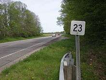
New England
See also
References
- ↑ Chris Marshall. "Road Numbers - How it happened". Retrieved 2009-07-10.
- ↑ "FOI Request - Road numbering" (PDF). Department for Transport. 5 August 2005. Retrieved 2010-08-12.
- ↑ Chris Marshall. "UK vs Italy". Retrieved 2009-07-10.
- ↑ Daniel P. Faigin. "California Highways - Numbering Conventions: Post Miles". Retrieved 2009-07-10.