Charing Cross
| Charing Cross | |
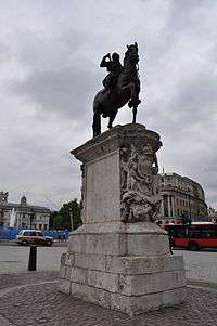 Charing Cross Roundabout, showing the Statue of Charles I, situated on the site of the original Eleanor Cross |
|
 Charing Cross |
|
| OS grid reference | TQ302804 |
|---|---|
| London borough | Westminster |
| Ceremonial county | Greater London |
| Region | London |
| Country | England |
| Sovereign state | United Kingdom |
| Post town | LONDON |
| Postcode district | WC2 |
| Dialling code | 020 |
| Police | Metropolitan |
| Fire | London |
| Ambulance | London |
| EU Parliament | London |
| UK Parliament | Cities of London and Westminster |
| London Assembly | West Central |
Coordinates: 51°30′26″N 0°07′39″W / 51.5073°N 0.12755°W
Charing Cross (/ˌtʃærɪŋ ˈkrɒs/)[1] denotes the junction of Strand, Whitehall and Cockspur Street, just south of Trafalgar Square in central London. It gives its name to several landmarks, including Charing Cross railway station, one of the main London rail terminals.
Charing Cross is named after the Eleanor cross that stood on the site, in what was once the hamlet of Charing. The site of the cross has been occupied since 1675 by an equestrian statue of King Charles I. A loose Victorian replica of the medieval cross, the Queen Eleanor Memorial Cross, was erected a short distance to the east outside the railway station.
Until 1931, "Charing Cross" referred to the part of Whitehall between Great Scotland Yard and Trafalgar Square.[2] At least one property retains a "Charing Cross" postal address: Drummonds Bank, on the corner of Whitehall and The Mall, which is designated "49 Charing Cross" (not to be confused with Charing Cross Road).[3]
Since the early 19th century, Charing Cross has often been regarded as the notional "centre of London", and is now the point used to measure distances from London.
History
Location and etymology
"Erect a rich and stately carved cross,Whereon her statue shall with glory shine;
And henceforth see you call it Charing Cross." George Peele The Famous Chronicle of King Edward the First (1593)
The name of the area, Charing, is derived from the Old English word "cierring", referring to a bend in the River Thames.[4][5]
The addition of the name "Cross" to the hamlet's name originates from the Eleanor cross erected in 1291–94 by King Edward I as a memorial to his wife, Eleanor of Castile,[6] and placed between the former hamlet of Charing and the entrance to the Royal Mews of the Palace of Whitehall (today the top of Whitehall on the south side of Trafalgar Square). Folk etymology suggests the name derives from chère reine — "dear queen" in French — but the original name pre-dates Eleanor's death by at least a hundred years.[7]
This wooden sculpted cross was the work of the medieval sculptor, Alexander of Abingdon,.[8] It was destroyed in 1647 on the orders of Parliament during the Civil War.[9] A 70 ft (21 m)-high stone sculpture in front of Charing Cross railway station is a copy of the original cross. Erected in 1865, it is situated a few hundred yards to the east of the original cross, on the Strand. It was designed by the architect E.M.Barry and carved by Thomas Earp of Lambeth out of Portland stone, Mansfield stone (a fine sandstone) and Aberdeen granite. It is not a faithful replica, being more ornate than the original.[10]
A variation on the name appears to be "Charygcrouche", near St Martin in the Fields, in 1396. [11]
Since 1675 the site of the cross has been occupied by a statue of King Charles I mounted on a horse. The site is recognised by modern convention as the centre of London for the purpose of indicating distances by road in favour of other measurement points (such as St Paul's Cathedral which remains as the root of the English and Welsh part of the Great Britain road numbering scheme). Charing Cross is marked on modern maps as a road junction, and was previously a postal address denoting the stretch of road between Great Scotland Yard and Trafalgar Square. Since 1 January 1931 this section of road has been designated part of the Whitehall thoroughfare.[12]
The cross has given its name to a railway station, a tube station, police station, hospital, a hotel, a theatre, and a music hall (which lay beneath the arches of the railway station). Charing Cross Road the main route from the north (which becomes the east side of Trafalgar Square) was named after the railway station, which was a major destination for traffic, rather than for the original cross.[13]
St Mary Rounceval

At some time between 1232 and 1236, the Chapel and Hospital of St Mary Rounceval was founded at Charing. It occupied land at the corner of the modern Whitehall and into the centre of Northumberland Avenue, running down to a wharf by the river. It was an Augustinian house, tied to a mother house at Roncesvalles in the Pyrenees. The house and lands were seized for the king in 1379, under a statute "for the forfeiture of the lands of schismatic aliens". Protracted legal action returned some rights to the prior, but in 1414, Henry V suppressed the 'alien' houses. The priory fell into a long decline due to lack of money and arguments regarding the collection of tithes with the parish church of St Martin-in-the-Fields. In 1541, religious artefacts were removed to St Margaret's, and the chapel was adapted as a private house and its almshouse were sequestered to the Royal Palace.[14]
.JPG)
In 1608–09, the Earl of Northampton built Northumberland House on the eastern portion of the property. In June 1874, the whole of the duke's property at Charing Cross, was purchased by the Metropolitan Board of Works for the formation of Northumberland Avenue.[15]
The frontage of the Rounceval property caused the narrowing at the end of the Whitehall entry to Charing Cross, and formed the section of Whitehall formerly known as Charing Cross, until road widening in the 1930s caused the rebuilding of the south side of the street – creating the current wide thoroughfare.[14]
Battle
In 1554, Charing Cross was the site of the final battle of Wyatt's Rebellion. This was an attempt by Thomas Wyatt and others to overthrow Queen Mary I of England, soon after her accession to the throne and replace her with Lady Jane Grey. Wyatt's army had come from Kent, and with London Bridge barred to them, had crossed the river by what was then the next bridge upstream, at Hampton Court. Their circuitous route brought them down St. Martin's Lane to Whitehall.[10]
The palace was defended by 1,000 men under Sir John Gage at Charing Cross; they retreated within Whitehall after firing their shot, causing consternation within – thinking the force had changed sides. The rebels – themselves, fearful of artillery on the higher ground around St James's – did not press their attack and marched onto Ludgate; where they were met by the Tower Garrison and surrendered.[10]
Civil war removal

The Eleanor Cross was pulled down, by order of Parliament, in 1647, at the time of the English Civil War, becoming the subject of a popular Royalist ballad:
- Methinks the common-council shou'd
- Of it have taken pity,
- 'Cause, good old cross, it always stood
- So firmly in the city.
- Since crosses you so much disdain,
- Faith, if I were you,
- For fear the King should rule again,
- I'd pull down Tiburn too. (extract from "The Downfall of Charing Cross"[16])
At the Restoration eight of the regicides were executed here, including the notable Fifth Monarchist, Colonel Thomas Harrison.[17] A statue of Charles I was later erected on the site. This statue had been made in 1633 by Hubert Le Sueur, in the reign of Charles I, but in 1649 was ordered to be destroyed by Parliament. Subsequently, after being hidden by the man charged with destroying the statue, it resurfaced at the Restoration, and was erected here in 1675.[18]

A prominent pillory, where malefactors were publicly flogged, was situated next to the statue of King Charles.[20] To the south of Charing Cross was the Hungerford Market, established at the end of the 16th century; and to the north was the King's Mews, a royal stable. The area around the pillory was a popular place of street entertainment. Samuel Pepys records in his diaries visiting the surrounding taverns and watching the entertainments and executions that were held there.[21] This whole area was transformed when Trafalgar Square was built on the site in 1832.
A famous inn called the "Golden Cross" – first mentioned in 1643 – stood in the former village of Charing. From here, in the eighteenth and nineteenth centuries, coaches departed by various routes to Dover, Brighton, Bath, Bristol, Cambridge, Holyhead and York. The inn features in Sketches by Boz, David Copperfield and The Pickwick Papers by Charles Dickens. In the last, the dangers to public safety of the low archway between the inn to the street were memorably pointed out by Mr Jingle :
"Heads, heads – take care of your heads", cried the loquacious stranger as they came out under the low archway which in those days formed the entrance to the coachyard. "Terrible place – dangerous work – other day – five children – mother – tall lady, eating sandwiches – forgot the arch – crash – knock – children look round – mother's head off – sandwich in her hand – no mouth to put it in – head of family off"
The inn was demolished for the creation of Trafalgar Square and a new Golden Cross Hotel was built in the 1830s on the triangular site now fronted by South Africa House. Though this hotel is now also gone, the memory is preserved in commercial offices facing the Strand named Golden Cross House.
Replacement

The railway station opened in 1864, fronted on the Strand with the Charing Cross Hotel. In 1865, a replacement cross was commissioned from E. M. Barry by the South Eastern Railway as the centrepiece of the station forecourt. It is not a replica, being of an ornate Victorian Gothic design based on George Gilbert Scott's Oxford Martyrs' Memorial (1838). The Cross rises 70 feet (21 m) in three main stages on an octagonal plan, surmounted by a spire and cross. The shields in the panels of the first stage are copied from the Eleanor Crosses and bear the arms of England, Castile, Leon and Ponthieu; above the 2nd parapet are 8 statues of Queen Eleanor. The Cross was designated a Grade II* monument on 5 February 1970.[22] The month before, the bronze equestrian statue of Charles, on a pedestal of carved Portland stone was given Grade I listed protection.[23]
Fragments of the medieval original remain in the Museum of London.
Official use as central point
By the late 18th century, Charing Cross was increasingly coming to be perceived as the "centre" of the metropolis (supplanting the traditional heartland of the City to the east).[24] From the early 19th century, legislation applicable only to the London metropolis used Charing Cross as a central point to define its geographical scope. Its later use in legislation waned in favour of providing a schedule of local government areas and became mostly obsolete with the official creation of Greater London in 1965.
| Use | Scope |
|---|---|
| Metropolitan Police District | The Metropolitan Police Act 1829 made provision that all parishes within 12 miles of Charing Cross could be added. This was expanded to 15 miles by the Metropolitan Police Act 1839. |
| Metropolitan Buildings Office | The London Building Act 1844 allowed that any place within 12 miles of Charing Cross could be added to the area of responsibility. |
| Hackney carriage licensing & The Knowledge | The London Hackney Carriage Act 1831 and subsequent legislation set the radius within which cab drivers were obliged to take a fare. Streets within a six-mile radius of Charing Cross are still included in taxi driver training. |
| Street Trading | The Metropolitan Streets Act 1856 gave the Commissioner of Metropolitan Police the power to control various activities within a six-mile radius of Charing Cross. Powers to licence shoeblack pitches are still in force but in practice are superseded by individual London boroughs' street trading arrangements. |
.jpg)
Road distances from London continue to be measured from Charing Cross. Prior to its selection as a commonly agreed central datum point, various points were used for this purpose. John Ogilby's Britannia of 1675, of which editions and derivations continued to be published throughout the 18th century, used the "Standard" (a former conduit head) in Cornhill;[25] John Cary's New Itinerary of 1798 used the General Post Office in Lombard Street;[26] while the milestones on the principal turnpike roads were generally measured from the terminus of the individual road, mostly on the perimeter of the metropolitan area: these points included Hyde Park Corner, Whitechapel Church, the southern end of London Bridge, the southern end of Westminster Bridge, Shoreditch Church, Tyburn Turnpike, Holborn Bars, St Giles's Pound, Hicks Hall (the terminus of the Great North Road), and the Stones' End in The Borough.[27][28] Some roads into Surrey and Sussex were measured from St Mary-le-Bow church.[29][30] Some of these objects had been moved or destroyed, but their former locations continued to be used for distances. The result was that "all the Books of Roads ... published, differ in the Situation of Mile Stones, and instead of being a Guide to the Traveller, serve only to confound him".[31] William Camden speculated in 1586 that Roman roads in Britain had been measured from London Stone, a claim that was subsequently widely repeated, but that is unsupported by archaeological or other evidence.[28][32]
Neighbouring locations
 |
Trafalgar Square | Covent Garden | Kingsway | |
| The Mall | |
Strand | ||
| ||||
| | ||||
| Whitehall | London Waterloo via Golden Jubilee Bridges |
South Bank via Waterloo Bridge |
Transport

To the east of the Charing Cross road junction is Charing Cross railway station, situated on the Strand. On the other side of the river, connected by the pedestrian Golden Jubilee Bridges, are Waterloo East station and Waterloo station.
The nearest London Underground stations are Charing Cross and Embankment.
References
- ↑ "Charing Cross" entry in Collins English Dictionary, HarperCollins Publishers, 1998.
- ↑ Local attractions – Charing Cross, londoncountyhall.com
- ↑ http://www.flickr.com/photos/funfilledgeorgie/6350385659/ (note also "Charing Cross" street sign, upper left)
- ↑ "Charing Cross – Britannica Online Encyclopedia". library.eb.co.uk. Retrieved 7 July 2010.
- ↑ Helen Bebbington London Street Names (1972) –
- ↑
 Chisholm, Hugh, ed. (1911). "Charing Cross". Encyclopædia Britannica. 5 (11th ed.). Cambridge University Press. pp. 859–860.
 - ↑ "The Eleanor Crosses". Eleanor of Castille. Museum of London. Retrieved 12 November 2013.
- ↑ Medieval and Renaissance: Past, Present and Future: Charing Cross Stuart Frost (Victoria and Albert Museum) accessed 13 February 2009
- ↑ Where Is The Centre Of London? BBC
- 1 2 3 Charing Cross, the railway stations, and Old Hungerford Market, Old and New London: Volume 3 (1878), pp. 123–134. accessed: 13 February 2009
- ↑ Plea Rolls of the Court of Common Pleas; National Archives. CP 40/541; second entry, where one of the plaintiffs is from Flete Strete; http://aalt.law.uh.edu/AALT6/R2/CP40no541a/bCP40no541adorses/IMG_0876.htm; Charyngcrouche appears split between lines 4 & 5
- ↑ Harold P. Clunn (1970) The Face of London: 254
- ↑ Shaftesbury Avenue and Charing Cross Road, Survey of London: volumes 33 and 34: St Anne Soho (1966), pp. 296–312. Date accessed: 3 March 2009
- 1 2 The chapel and hospital of St. Mary Rounceval, Survey of London: volume 18: St Martin-in-the-Fields II: The Strand (1937), pp. 1–9. Date accessed: 14 February 2009
- ↑ Northumberland House, Survey of London: volume 18: St Martin-in-the-Fields II: The Strand (1937), pp. 10–20. Date accessed: 14 February 2009
- ↑ Alan Brooke and David Brandon (2004). Tyburn: London's Fatal Tree. Stroud, Sutton: 238
- ↑ Ben Weinreb and Christopher Hibbert (1983) The London Encyclopaedia: 138
- ↑ Ben Weinreb and Christopher Hibbert (1983) The London Encyclopaedia: 815
- ↑ A print drawn by Augustus Pugin and Thomas Rowlandson for Rudolph Ackermann's Microcosm of London (1808–11).
- ↑ Arthur Groom (1928) Old London Coaching Inns and Their Successors: 3
- ↑ Pepys Diary – frequent visits between 1660–69. Particularly 13 October 1660 – for his account of the execution of Harrison.
- ↑ Historic England. "Details from image database (427795)". Images of England. Retrieved 13 February 2009.
- ↑ Historic England. "Details from image database (209087)". Images of England. Retrieved 13 February 2009.
- ↑ Barrell, John (2006). The Spirit of Despotism: invasions of privacy in the 1790s. Oxford: Oxford University Press. pp. 20–27, 34. ISBN 978-0-19-928120-6.
- ↑ Ogilby, John (1675). "Preface". Britannia. London.
- ↑ Cary, John (1798). "Advertisement". Cary's New Itinerary. London.
- ↑ Paterson, Daniel. A New and Accurate Description of all the Direct and Principal Cross Roads in Great Britain (12th ed.). London. p. x.
- 1 2 Answers and Returns Made Pursuant to an Act: Passed in the Eleventh Year of the Reign of His Majesty King George IV. Intituled "An Act for Taking an Account of the Population of Great Britain, and of the Increase Or Diminution Thereof". January 1833. p. 498.
- ↑ Hissey, James J. (1910). The Charm of the Road. London: Macmillan. p. 58. OCLC 5071681.
- ↑ Historic England. "Bow Bell Milestone 35 miles from London (1252622)". National Heritage List for England. Retrieved 9 July 2015.
- ↑ The Traveller's Pocket-Book: or, Ogilby and Morgan's Book of the Roads Improved and Amended, in a method never before attempted. London. 1760. p. iv.
- ↑ Clark, John (2007). "Jack Cade at London Stone". Transactions of London and Middlesex Archaeological Society. 58: 169–89 (178).
External links
- Charing Cross Bridge in London from Claude Monet, in YOUR CITY AT THE THYSSEN, a Thyssen Museum project on Flickr
- 'The statue of Charles I and site of the Charing Cross', Survey of London: volume 16: St Martin-in-the-Fields I: Charing Cross (1935), pp. 258–268. URL: http://www.british-history.ac.uk/report.aspx?compid=68141 Date accessed: 6 March 2014.