Hastings, New Zealand
| Hastings Heretaunga (Māori) | |
|---|---|
| City | |
|
From top clockwise: Hastings CBD at night, Hawke's Bay Opera House, Tukituki Valley from Te Mata Peak, Sky Castle at Splash Planet, Saint Matthews Church. | |
|
Nickname(s): Fruit Bowl of New Zealand http://www.cityofhastings.co.nz/ | |
|
Motto: Great things grow here http://greatthingsgrowhere.co.nz/ | |
|
Hastings Hastings | |
| Coordinates: 39°39′0″S 176°50′0″E / 39.65000°S 176.83333°E | |
| Country |
|
| Region | Hawke's Bay |
| Territorial authority | Hastings District |
| Government | |
| • Mayor | Lawrence Yule |
| • Deputy Mayor | Cynthia Bowers |
| Area | |
| • City | 5,229 km2 (2,019 sq mi) |
| Elevation | 11 m (36 ft) |
| Population (June 2016)[1] | |
| • City | 78,600 |
| • Density | 15/km2 (39/sq mi) |
| • Urban | 68,900 |
| Postcode(s) | 4120, 4122 |
| Website | HastingsDC.govt.nz |

Hastings (/ˈheɪstɪŋz/; Māori: Heretaunga) is a New Zealand city and is one of the two major urban areas in Hawke's Bay, on the east coast of the North Island of New Zealand. The population of Hastings is about 68,900 as of the June 2016.[1] Hastings is about 18 kilometres inland of the coastal city of Napier. These two neighbouring cities are often called "The Bay Cities" or "The Twin Cities". The combined population of the Napier-Hastings Urban Area is 131,000 people, which makes it the sixth-largest urban area in New Zealand, closely following Tauranga (134,400).
The city is the administrative centre of the Hastings District. The city of Hastings and its outlying suburbs of Flaxmere and Havelock North are the principal settlements in the Hastings District. These main centres are surrounded by thirty-eight rural settlements, including Clive and Haumoana. Hastings District covers an area of 5,229 square kilometres (2,019 sq mi) and has 1.7 % of the population of New Zealand, ranking it fourteenth in size out of the seventy-four territorial authorities. Since the merger of the surrounding and satellite settlements, Hastings has grown to become the one of the largest urban areas in Hawke's Bay.
Hastings District is a food production region. The fertile Heretaunga Plains surrounding the city produce stone fruits, pome fruit, kiwifruit and vegetables, and the area is one of New Zealand's major red wine producers. Associated business include food processing, agricultural services, rural finance and freight. Hastings is the major service centre for the surrounding inland pastoral communities and tourism.
History
Māori history
Near the fourteenth century CE, Māori arrived in Heretaunga or Hawke's Bay, settling in the river valleys and along the coast where food was plentiful. It is believed that Māori arrived at Heretaunga by canoe, travelling down the coast from the north, landing at Wairoa, Portland Island, the Ahuriri Lagoon at Westshore, and at Waimarama. Their culture flourished, along with gradual deforestation of the land, making this one of the few regions of New Zealand where sheep could be brought in without felling the bush first. In the sixteenth century, Taraia, great-grandson of the great and prolific chief Kahungunu, established the large tribe of Ngāti Kahungunu, which eventually colonised the eastern side of the North Island from Poverty Bay to Wairarapa. They were one of the first Māori tribes to come in contact with European settlers.
European settlers' history

The Māori owners leased approximately seventy square kilometres on the Heretaunga Plains to Thomas Tanner in 1867; Tanner had been trying to purchase the land since 1864. In 1870, twelve people, known as the "12 apostles", formed a syndicate to purchase the land for around £1 10s an acre (£371 per km2). Many local people firmly believe that Hastings was originally named Hicksville, after Francis Hicks, who bought a 100-acre (0.40 km2) block of land, which now contains the centre of Hastings, from Thomas Tanner. However, this story is apocryphal. The original name of the location which was to become the town centre was Karamu.
In 1871, the New Zealand Government decided to route the new railway south of Napier through a notional Karamu junction in the centre of the Heretaunga Plains. This location was on Francis Hicks's land. The decision on the railway route was based largely on two reports by Charles Weber, the provincial engineer and surveyor in charge of the railway. Karamu junction was renamed Hastings in 1873. (On 7 June 1873, the Hawke's Bay Herald reported: "The name of the new town is to be Hastings. We hear it now for the first time.") Exactly who chose the name has been disputed, although Thomas Tanner claimed that it was him (see Hawke's Bay Herald report 1 February 1884) and that the choice was inspired by his reading the trial of Warren Hastings. In any event, the name fitted well with other place names in the district (Napier, Havelock and Clive), which were also named after prominent figures in the history of British India.[2] In 1874, the first train took the twelve-mile (19 km) trip from Napier to Hastings, opening up Hastings as an export centre, through Port Ahuriri. A big jump in the local economy occurred when Edward Newbigin opened a brewery in 1881. By the next year, there were 195 freeholders of land in the town and with around six hundred people, the town was incorporated as a borough on 20 October 1886.
Hastings first received power in 1912,[3] followed by Napier in 1915.[4]
In 1918, nearly 300 people died of a flu epidemic that swept Hawke's Bay.
1931 earthquake
On 3 February 1931, at 10:47 am, most of Hastings (and nearby Napier) was levelled by an earthquake measuring 7.8 on the Richter Scale. In Hastings, the ground subsided roughly 1 metre. The collapse of buildings and the ensuing fires killed 258 people, of which 93 were in Hastings. The centre of Hastings was destroyed in the earthquake, and was subsequently rebuilt in the Art Deco and Spanish Mission styles, which were both popular at that time. Due to quick thinking by residents and the Local Fire Department, Hastings did not suffer the extent of fire damage that Napier did. Most deaths were attributed to collapsing buildings, namely Roaches' Department Store in Heretaunga Street where 17 people died.[5]
1932 to 1999

During World War II, Allied troops were billeted at the Army, Navy and Air Force (ANA) Club, and in private homes. One hundred and fifty members belonging to sixteen different local clubs packed supplies to be sent to Allied soldiers. In 1954, Hastings was the first city in New Zealand to introduce fluoridation of its water supply.[6] The intention was to compare the effect on tooth decay with that in the unfluoridated city of Napier over a ten-year period. The study was criticised for its methodology and results, and remains controversial.[7]
On 10 September 1960, the Hastings Blossom Parade (at the time a significant national event) was cancelled at 11 am for the first time in its history due to rain. Parade attendees drank in bars for several hours and when, subsequently, an 'impromptu' parade began at 2 pm, a riot started as police tried to arrest those intoxicated in public. This was considered a significant event in New Zealand society with modern youth rebellion culture being labelled antisocial, and was subsequently much publicised with the national election later that year.
Hastings grew rapidly throughout the 1960s and 1970s (Hastings at this time was the fastest growing city in New Zealand), and there was a major issue dealing with encroachment of suburban expansion on highly productive land. Flaxmere was established as a satellite suburb to absorb rapid growth and was built upon the stony arid soils of the abandoned course of the Ngaruroro River. Although the land seemed worthless back then, it has subsequently proved highly valued for grape growing, and now is a prized region of red wine varietals in the world-famous Gimblett Gravels wine-growing region. Starting with economic decline nationally in the late 1970s, coupled with agricultural subsidy reforms in the early 1980s, Hastings went into recession with more unemployment and low economic growth. It was not until the mid 1990s that the economy of Hastings began to turn around.
During the 1989 local government reforms Hastings City amalgamated with the Havelock North Borough and Hawke's Bay County to form the modern Hastings District. The County Council offices in Napier were closed in favour of Hastings and the new Hastings District Council offices were built on two sites. The Napier City boundary was expanded to include Bay View and Meeanee. However, unlike largely urban Napier (population density 540.0 per km2), much of the newly formed Hastings District is rural and sparsely populated (population density 14.0 per km2), the Hastings District has approximately 78,600 (June 2016)[1] residents.
Because of their proximity to each other and their relatively small populations, Hastings and Napier are often seen as candidates for further amalgamation. This was attempted with the 1999 Amalgamation Referendum where 75% of Napier residents opposed, and 64% of Hastings residents were in support.
2000 to today
At 11.25 pm on 25 August 2008, the city was hit by an earthquake measuring 5.9 on the Richter scale.[8] The epicentre was based only 10 km south of the city, near Mt Erin at a depth of 32 km. The earthquake caused minor damage to shops, where stock was shaken off shelves. Power outages were also reported. This was the most powerful earthquake to hit the region since the 5.8 Hastings earthquake in October 2001.[9]
In 2010, the city, together with New Plymouth became one of the two walking and cycling "model communities", qualifying for further co-funding by the national government to improve its walking paths and cycleways, and encourage people to use active forms of transport.[10]
In August-September 2016, 5,200 people [11] fall ill with Campylobacter [12] after the local water supply in Havelock North tested positive for E-coli. Two deaths have occurred, both of which were in nursing homes due to Campylobacter that had developed from gastroenteritis.[13] It is suspected that after heavy rain fell on the 6–7 August, water contamination from flooding was cause of the outbreak, although this is still up for discusison. It is the largest outbreak of waterborne disease to ever occur in New Zealand. All schools in Havelock North closed for two weeks, with the Hastings District Council advising an urgent notice to boil water for at least one minute before consumption. This notice was lifted on September the 3rd, with the outbreak officially under control. Chlorination of the Havelock North water supply occurred on Friday the 12th, and 9 water tankers were brought in containing water from the Hastings water supply. One of these trucks again tested positive for E-Coli contamination, prompting the Hastings District Council to chlorinate the water supply of both Hastings and Flaxmere as a precautionary measure.[14][15]
Timeline
- 1867: Māori owners leased 70 sq kilometres of land from the Heretaunga Plains to Thomas Tanner, it was the site of Karamu Junction.
- 1873: The town of Karamu Junction is officially renamed Hastings.
- 1874: Hastings (along with Napier) is connected to the North Island Main Trunk Line.
- 1886: 20 October. Hastings town is incorporated as a Borough.
- 1912: Hastings is connected to electricity, followed by Napier in 1915.
- 1918: Nearly 300 people die of a flu epidemic that swept Hawke's Bay.
- 1931: 3 February. Hastings is rocked by a 7.8 magnitude earthquake, killing 256 people (93 in Hastings).
- 1932: 16 September. Hastings is rocked by a 6.9 magnitude earthquake. It is the final large earthquake in the 1931–1932 earthquake events.
- 1950: The first Blossom Parade was held in Hastings and is now a popular annual event.
- 1951: 10 February. Hastings is rocked by a 6.1 magnitude earthquake at 3:27 pm.
- 1954: Hastings was the first city in New Zealand to introduce fluoridation of its water supply.
- 1960: 10 September. The Hastings Blossom Parade (at the time a significant national event) was cancelled at 11 am for the first time in its history due to rain.
- 1989: Hastings City and the Havelock North Borough amalgamated to form the modern day Hastings District.
- 1993: 11 April. A 6.1 magnitude earthquake strikes 15 km south-west of Hastings and is felt as far south as Christchurch.
- 2008: 25 August. A 5.9 magnitude earthquake centred 10 km south of Hastings caused an estimated $5 million in damage.
- 2010: The city became a walking and cycling "model community".
- 2016: August and September. 5,200 residents fall ill with Campylobacter, prompting a district-wide health crisis. It is the largest outbreak of waterborne disease to ever occur in New Zealand.
Geography and climate
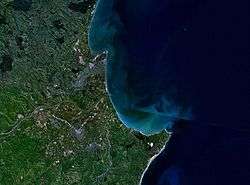
Located on New Zealand's east coast, to the east of the Central Plateau and the rain shadow of the Kaweka Ranges, Hastings is situated on the fertile alluvial Heretaunga Plains. The plains were originally covered in swamp and mangroves, but have since been drained for agriculture. The local area is very productive, with orchards, farms and vineyards, and lies upon New Zealand's most economically valuable aquifer.[16] Hastings lies roughly 250 km north-east of the nation's capital Wellington (294 km by road) and 350 km south east of the largest city, Auckland (429 km by road).
 |
Napier | | ||
| Taihape and Tongariro National Park | |
Cape Kidnappers | ||
| ||||
| | ||||
| Waipukurau | Ocean Beach and Waimarama |
Hastings enjoys an oceanic climate (according to Köppen climate classification). It is a common misconception that it is a Mediterranean climate, mainly due to hot summers and low annual rainfall. However, the driest month, November, has more than one third of the rainfall of the wettest month hence it is not a true Mediterranean climate. Sunshine hours rank over 2200 annually while rainfall averages less than 800 mm (31.5 in). It is one of the country's warmest urban areas annually. Because of its location 15 km (9.3 mi) inland, the sea breeze does not tend to have the same effect on Hastings' climate as it does on Napier. It is not uncommon for the temperature to be in the low30 °C's (90 °F) on summer days, while in winter, days of 15 °C+ (37 °F) are frequent, occasionally exceeding 20 °C (25 °F) with north-west winds. Winters tend to be quite still and crisp with frequent frosts, followed by bright, cold, sunny days.
| Climate data for Hastings | |||||||||||||
|---|---|---|---|---|---|---|---|---|---|---|---|---|---|
| Month | Jan | Feb | Mar | Apr | May | Jun | Jul | Aug | Sep | Oct | Nov | Dec | Year |
| Record high °C (°F) | 35.8 (96.4) |
37.1 (98.8) |
33.4 (92.1) |
28.9 (84) |
27.1 (80.8) |
23.4 (74.1) |
22.5 (72.5) |
22.7 (72.9) |
26.4 (79.5) |
29.0 (84.2) |
31.8 (89.2) |
36.5 (97.7) |
37.1 (98.8) |
| Average high °C (°F) | 25.5 (77.9) |
25.4 (77.7) |
23.6 (74.5) |
20.7 (69.3) |
17.1 (62.8) |
14.4 (57.9) |
13.9 (57) |
14.9 (58.8) |
17.5 (63.5) |
20.0 (68) |
22.3 (72.1) |
24.1 (75.4) |
20.0 (68) |
| Average low °C (°F) | 13.7 (56.7) |
14.0 (57.2) |
12.2 (54) |
9.1 (48.4) |
6.7 (44.1) |
3.9 (39) |
3.6 (38.5) |
4.8 (40.6) |
6.1 (43) |
8.0 (46.4) |
10.4 (50.7) |
12.6 (54.7) |
8.8 (47.8) |
| Record low °C (°F) | 5.4 (41.7) |
5.0 (41) |
2.7 (36.9) |
0.6 (33.1) |
−3.0 (26.6) |
−4.2 (24.4) |
−5.0 (23) |
−3.3 (26.1) |
−2.8 (27) |
−2.0 (28.4) |
1.7 (35.1) |
3.2 (37.8) |
−5.0 (23) |
| Average precipitation mm (inches) | 66 (2.6) |
53 (2.09) |
61 (2.4) |
48 (1.89) |
81 (3.19) |
79 (3.11) |
64 (2.52) |
86 (3.39) |
46 (1.81) |
46 (1.81) |
41 (1.61) |
53 (2.09) |
724 (28.5) |
| Source: NIWA Climate Data[17] | |||||||||||||
Demographics
| Largest groups of overseas-born residents[18][19] | |
| Nationality | Population (2013) |
|---|---|
| | 3,723 |
| | 960 |
| | 939 |
| | 750 |
| | 522 |
| | 399 |
| | 324 |
| | 264 |
| | 213 |
| | 213 |
| Historical population | ||
|---|---|---|
| Year | Pop. | ±% p.a. |
| 1991 | 64,000 | — |
| 1996 | 66,300 | +0.71% |
| 2001 | 67,400 | +0.33% |
| 2006 | 70,800 | +0.99% |
| 2013 | 73,200 | +0.48% |
| Source: [20] | ||
Hastings District encompasses a large area of Hawke's Bay. The population of Hastings District is 77,400 (population density 15.0 per km2). The central urban area however which is specifically the population centre of Hastings, Flaxmere, and Havelock North is around 73,000. Due to restrictions on encroachment of land, satellite suburbs have absorbed the residential expansion of the city. Compared to other cities of similar size, Hastings has grown relatively quick since it was settled in 1864 (over 150 years ago). Hastings is known for its gridiron city planning system, crisscrossed by the railway line running northeast–southwest and the main southeast–northwest artery, Heretaunga Street, which also links the city with its suburban centres of Havelock North and Flaxmere.
Many Hastings residents work in the city, and the area is populated by middle-to-upper income families, particularly in Havelock North and then middle-to-lower income families in other areas, namely Camberley and the north end of Flaxmere.
At the 2013 census, Hastings District had a population of 73,245, an increase of 2,803 people, or 2.9 percent, since the 2006 census. There were 27,042 occupied dwellings, 2,334 unoccupied dwellings, and 123 dwellings under construction.[21] Hastings's ethnicity was made up of (national figure in brackets): 75,2 percent European (75.0 percent), 24.4 percent Māori (14.9 percent), 4.3 percent Asian (11.2 percent), 6.0 percent Pacific Islanders (7.4 percent), 0.5 percent Middle Eastern/Latin American/African (1.2 percent), and 1.8 percent 'New Zealanders'. Hastings had an unemployment rate of 6.9 percent of people 15 years and over, compared to 7.1 percent nationally. The average annual income of all people 15 years and over in Hastings was $26,500, compared to $28,500 nationally. Of those, 39.1 percent earned under $20,000 annually, compared to 38.2 percent nationally, while 22.3 percent earned over $50,000 annually, compared to 26.7 percent nationally.

City suburbs: Anderson Park, Akina, Camberley, Flaxmere East, Frimley, Iona, Hastings CBD, Havelock North Central, Kingsley-Chatham, Lochain, Mahora, Mayfair, Parkvale, Raureka, Saint Leonards, Stortford Lodge, Te Mata, Te Mata Hills, Tomoana, Waipatu, Whakatu, Woolwich.
Outlying communities: Bridge Pa, Karamu, Longlands, Mangateretere, Maraekakaho, Omahu/Fernhill, Pakipaki, Pukahu, Twyford.
Economy

Hastings District, as one of the largest apple, pear and stone fruit producing areas in New Zealand, has an important relationship with the Napier Port. It has also become an important grape growing and wine production area with the fruit passing from the growers around Metropolitan Hastings and then to Napier for exporting. Napier is an important service centre for the agriculture and pastoral output of the predominantly rural Hastings District. Shopping is heavily weighted by large format retail in Hastings City, whereas in contrast, Havelock North, Taradale and central Napier retail areas have a more vibrant boutique flavour.
Redevelopment
By the end of the twentieth century Hastings, along with most of New Zealand was suffering from the recent economic downturn with industries and freezing works closing due to the agricultural subsidy reforms in the early 1980s. However, after multimillion-dollar regeneration projects and the employment of artists, Hastings has seen a change in its aesthetics. A CBD strategy was enforced to revitalise the central retail core, while promoting Havelock North as a 'luxury boutique' destination. The strategy proved extremely successful and Hastings vacancy rates hit an all-time low in 2005. The current goal of the council is to continue developing Hastings CBD to attract additional national chains, while attracting more cafes and entertainment venues is currently active in the eastern blocks of Heretaunga St.
The Hastings District Council has recently relocated and consequently rebuild the Hastings Sports Park at a new facility on the edge of the Hastings urban area to make way for a large megacentre, also known as "large format stores". A comprehensive study was conducted before the sale concluding that retaining big box development within the CBD will help boutique stores prosper as opposed to locating the development on a greenfield site. Charter Hall, the developers behind 'The Park' megacentre, had confirmed as of August 2010, the major anchors of the development will be the relocation of Hawkes Bay's largest 'The Warehouse' and the relocation of the cities' Mitre 10 Mega. The new sports park is proposed as a regional facility and includes a velodrome, all-weather athletics track and sports grounds for most other sporting codes represented in NZ sport. Since its completion, the Hastings sports park now hosts multiple tennis courts, netball courts and an internationally recognised hockey turf.
Tourism

Hastings District is quite historic and is very welcoming of tourists, and features a tourism industry based on 'lifestyle' activities rather than attractions. The majority of tourists are domestic, usually from other regions within New Zealand. Scheduled airline services to Hawke's Bay operate through Hawke's Bay Airport, and the nearby Hastings Aerodrome is available for private planes. Tourism in Hawke's Bay is growing at an extremely rapid rate. In the recent decade, Hawke's Bay Airport's annual passenger numbers have grown from a 2005 count of 297,000 to a count of 476,000 in the year ending 30 June 2015. In the next five years passenger numbers are expected to exceed 550,000, bringing many new people into Hawke's Bay, with Hastings benefiting from the greater tourism.[22]
Hastings' largest draw card is the wine and food trail established around the productive hinterland. There are over 75 wineries in the surrounding area, including New Zealand's oldest winery restaurant (Vidal Estate). Boutique food industries are becoming popular with cheese, fine meats, and locally produced delicacies seen on display at the Hawkes Bay Farmer's Market (New Zealand's oldest and largest weekly farmer's market). Outdoor leisure activities dominate, with beaches, river, mountain biking, tramping, and golf, being popular. In summer, many large scale events attract domestic tourists including the Spring Racing Carnival, The Blossom Parade, Harvest Hawkes Bay Weekend, and various concerts and events. The Blossom Festival was once a large national event in the mid-20th century, with charter trains from Wellington and Auckland coming for the event. This however has slowly declined in popularity.
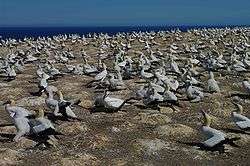
Hastings' specialist attractions include: New Zealand's largest water park, called 'Splash Planet', which replaced 'Fantasyland' near the turn of the millennium, Cape Kidnappers (the world's largest mainland gannet colony), Te Mata Peak, and access to an abundance of nature reserves and mountain treks. Architecturally speaking, Hastings suffered similar to Napier in the 1931 Hawke's Bay earthquake. However, because of the lesser damage by fire, Hastings maintained more pre earthquake buildings. Both towns gained a legacy from the disaster by rebuilding in the then-fashionable and highly distinctive Art Deco style, similar to that of Miami, FL, USA. Hastings also possesses a large amount of Spanish Mission architecture (popular as with Art Deco in the early 1930s). Sadly, Hastings succumbed to rapid redevelopment in the 1960s–70s which saw many 1930s buildings replaced.
Horse of the Year show
Hawkes Bay A&P Showgrounds in Hastings is the home to the annual NZ Horse of the year show, held in March. It is one of the biggest sporting events in the Southern Hemisphere, and attracts 2500 horse and rider combinations competing in 19 disciplines including Dressage, Showhunter, Eventing, Showjumping and polocrosse and many breed classes to name a few. It has a budget of around $NZD3million, and attracts over 70,000 visitors from over NZ and internationally over the 5-day show.
Transport
Road
Hastings is served by State Highway ![]() , which connects Hastings with Napier, Wairoa and Gisborne to the north and (via Dannevirke) Wellington, Masterton and Palmerston North to the south. SH2 jumps over Hastings, as it is not recognised as a State Highway within the urban boundaries of the city. Due to the road layout of Hastings, SH2's northern and southern sections did not meet up. This is the only point in SH2's continuation where there is a gap, and it is not shown on maps. SH2 enters and exits Hastings in a north east and south west direction. Heading north east, it passes through residential Hastings, then follows the Clive River through the towns of Whakatu and Clive, bridges across the Clive, Tutaekuri and Ngaruroro Rivers before following the coast into Napier. Heading south west, it crosses the Heretaunga Plains, passing through Longlands and Pakipaki, then follows the railway south through Poukawa Valley.
, which connects Hastings with Napier, Wairoa and Gisborne to the north and (via Dannevirke) Wellington, Masterton and Palmerston North to the south. SH2 jumps over Hastings, as it is not recognised as a State Highway within the urban boundaries of the city. Due to the road layout of Hastings, SH2's northern and southern sections did not meet up. This is the only point in SH2's continuation where there is a gap, and it is not shown on maps. SH2 enters and exits Hastings in a north east and south west direction. Heading north east, it passes through residential Hastings, then follows the Clive River through the towns of Whakatu and Clive, bridges across the Clive, Tutaekuri and Ngaruroro Rivers before following the coast into Napier. Heading south west, it crosses the Heretaunga Plains, passing through Longlands and Pakipaki, then follows the railway south through Poukawa Valley.
State Highway ![]() , begins at a junction just north of Takapau, and connects Hastings and Hawke's Bay to the Ruataniwha Valley and western Hawke's Bay. It provides an alternative, quieter and (in terms of distance) shorter route into Hawke's Bay. It also connects Hastings to many of Hawke's Bay's wineries, for which the region is known internationally. It makes up part of the Hawke's Bay Wine Trail.
, begins at a junction just north of Takapau, and connects Hastings and Hawke's Bay to the Ruataniwha Valley and western Hawke's Bay. It provides an alternative, quieter and (in terms of distance) shorter route into Hawke's Bay. It also connects Hastings to many of Hawke's Bay's wineries, for which the region is known internationally. It makes up part of the Hawke's Bay Wine Trail.
Hastings is connected to Napier through the Hawke's Bay Expressway, also known as the Napier-Hastings Expressway, and provides a more direct and efficient link between the two cities compared to SH2, and better access to Hawke's Bay Airport. The expressway also provides a more direct and efficient route to the Port of Napier for heavy-vehicle traffic coming from Hastings, as it allows them to avoid travelling through too much of the Hastings urban area. The expressway has connections to many of Hastings's arterial roads that lead to the city centre and outlying suburbs, such as the junctions at Omahu Road, York Road/Flaxmere Ave and Evenden Road.
Rail
The Palmerston North–Gisborne Line (PNGL) is a secondary main line railway in the North Island of New Zealand. The PNGL line runs right through the centre of Hastings (a city planned feature entirely unique to the city) and connects Hastings to the North Island Main Trunk Railway, near Palmerston North. The railway divides Hastings in a South-West to North-East direction and cuts off many of the main streets in the centre of the city, many being labelled as East/West depending on what side of the railway they originate from.
Passenger services ran into Hastings until it was closed in 2001 and the Hastings railway station is now a major centre for freight services along the PNGL line and provides the Port of Napier with many of its freight exports.
Coat of Arms
The city has a Coat of Arms and the Heraldic Blazon is;
- Arms
Per pale Vert and Argent, in dexter a cross-crosslet fitchy Or in sinister, on a cross carved with a Māori pattern Gules, a sun in splendour Or on a chief party per pale Argent and Vert, a lion passant guardant, armed and langued Gules within an orle of fern leaves all counterchanged. An inescutcheon Or charged with a manche Gules.
- Crest
On a wreath of the colours, clouds Argent, rays Or, a sunburst supporting a toothed wheel, perforated of six, centred and rimmed Argent, Gules.
- Supporters
Dexter, a ram, tail couped, horned and hoofed Or, proper, supporting on a staff proper palewise flying to the dexter an ensign Sable, two bars Argent edged and charged with a hawk rising Or. Sinister, a bull, armed and hoofed Or, supporting a staff property palewise flying to the sinister, edged Or, a New Zealand Ensign; all supported by a profusion of apples, pears, peaches, grapes and miro berries with their leaves, surmounting a Māori style carved panel representing Rongomatane and Haumeitikeitikei, all proper.
- Motto
Urbis Et Ruris Concordia (town and country in harmony)
Notable residents
Notable residents of the Hastings metro area have included:
- Donna Awatere Huata – politician convicted of fraud
- Joh Bjelke-Petersen – Premier of Queensland, Australia
- Martin Campbell – TV and film director
- John Cowie – developed and marketed the Jandal, and died in Te Awanga[23]
- Alan Duff – author (Once Were Warriors) and co-founder of Duffy Books in Homes
- Georgina Evers-Swindell – Olympic rowing gold medalist
- Caroline Evers-Swindell – Olympic rowing gold medalist
- Robert Felkin – medical missionary, explorer and ceremonial magician
- Paul Holmes – radio and television broadcaster
- Phil Judd – musician, composer and founding member of Split Enz
- Sam Kelt – businessman and sponsor of the Kelt Capital Stakes
- Josh Kronfeld – All Black rugby player who attended Hastings Boys High
- Alfred Meebold – botanist, writer, and anthroposopher
- Greg Murphy – V8 Supercar racer
- George Nepia – All Black who attended Maori Agricultural College
- Mark Paston – New Zealand representative football goalkeeper
- Abe Phillips - lead singer of Hastings band, The Shadracks
- Bruce Robertson – All Black rugby player who attended Hastings Boys High
- Taine Randell – rugby player who captained the All Blacks and attended Lindisfarne College in Hastings
- Jason Reeves – radio and television host who attended Karamu High School in Hastings
- Ian Smith – New Zealand representative cricketer
- John Timu – rugby player who represented New Zealand in rugby union and rugby league, and attended Lindisfarne College in Hastings
- James Wattie – industrialist/entrepreneur and founder of Wattie's
- Joan Wiffen – amateur palaeontologist who discovered the first dinosaur fossils in New Zealand
- Eric Young – Prime TV news presenter
Sister cities
Hastings' relationship with the Chinese city Guilin started in 1977, after a research scientist, Stuart Falconer, identified a number of common areas of interest between the two cities, including horticulture and their rural-urban mix.
|
Notes
- 1 2 3 "Subnational Population Estimates: At 30 June 2016 (provisional)". Statistics New Zealand. 21 October 2016. Retrieved 21 October 2016. For urban areas, "Subnational population estimates (UA, AU), by age and sex, at 30 June 1996, 2001, 2006-16 (2017 boundary)". Statistics New Zealand. 21 October 2016. Retrieved 21 October 2016.
- ↑ Boyd 1984, pp. 16–21.
- ↑ "Historic HB: Drive to provide electricity". Hawke's Bay Today. 28 August 2012. Retrieved 18 September 2012.
- ↑ "Napier Physical Development History". Napier City Council. 2012. Retrieved 18 September 2012.
- ↑ History Napier and Taradale – Napier City – Hawke's Bay – New Zealand
- ↑ Archived 23 November 2007 at the Wayback Machine.
- ↑ Archived 20 October 2006 at the Wayback Machine.
- ↑ "Quakes". GeoNet. 25 August 2008. Retrieved 29 January 2016.
- ↑ "Quakes". GeoNet. 15 October 2001. Retrieved 29 January 2016.
- ↑ "Bay cycling's 'without equal'". Hawke's Bay Today. 10 November 2010. Retrieved 12 November 2010.
- ↑ https://nz.news.yahoo.com/top-stories/a/32523128/havelock-water-no-longer-needs-boiling/#page1
- ↑ https://nz.news.yahoo.com/top-stories/a/32378798/dead-woman-contracted-campylobacter-coroner-says/#page1
- ↑ https://nz.news.yahoo.com/top-stories/a/32324357/tummy-bug-outbreak-lays-havelock-north-low/#page1
- ↑ https://nz.news.yahoo.com/top-stories/a/32367075/secondary-schools-reopen-in-havelock-north/#page1
- ↑ http://m.nzherald.co.nz/nz-herald-focus/news/article.cfm?c_id=1504018&objectid=11694777
- ↑ "Economic value of groundwater aquifers". Ministry of Economic Development. 2004. Archived from the original on 29 June 2007. Retrieved 21 April 2014.
- ↑ "CLINFO". NIWA. Retrieved 22 April 2009.
- ↑ "2013 Census QuickStats about culture and identity – Birthplace and people born overseas". Statistics New Zealand. Retrieved 29 September 2016.
- ↑ "Birthplace (detailed), for the census usually resident population count, 2001, 2006, and 2013 (RC, TA) – NZ.Stat". Statistics New Zealand. Retrieved 16 August 2014.
- ↑ "Infoshare; Group: Population Estimates – DPE; Table: Estimated Resident Population for Urban Areas, at 30 June (1991+) (Annual-Jun)". Statistics New Zealand. Retrieved 17 June 2015.
- ↑ "QuickStats about a place". Stats.govt.nz. 22 February 2011. Retrieved 29 January 2016.
- ↑ http://www.stuff.co.nz/travel/news/70371985/jetstar-making-return-trip-to-hawkes-bay
- ↑ "How jandals got their handle".
References
- Moss, Maryan. 1999. Historic Outline of the Hastings District.
- Boyd, Mary Beatrice (1984). City of the Plains – A History of Hastings. Victoria University Press for the Hastings City Council.
External links
| Wikivoyage has a travel guide for Hastings (New Zealand). |
- Hastings District Council
- Hawke's Bay Tourism
- Hastings on Google Maps
Coordinates: 39°39′S 176°50′E / 39.650°S 176.833°E