Harpersville, Alabama
| Harpersville, Alabama | |
|---|---|
| Town | |
 Location in Alabama | |
| Coordinates: 33°19′33″N 86°25′34″W / 33.32583°N 86.42611°W | |
| Country | United States |
| State | Alabama |
| County | Shelby |
| Government | |
| • Mayor | Theoangelo Perkins |
| Area | |
| • Total | 15.9 sq mi (41.1 km2) |
| • Land | 15.9 sq mi (41.1 km2) |
| • Water | 0 sq mi (0 km2) |
| Elevation | 456 ft (139 m) |
| Population (2010) | |
| • Total | 1,637 |
| • Density | 102.0/sq mi (39.4/km2) |
| Time zone | CST (UTC-6) |
| • Summer (DST) | CDT (UTC-5) |
| ZIP code | 35078 |
| Area code(s) | 205 |
| FIPS code | 01-33256 |
| GNIS feature ID | 0119777 |
| Website | City Website |
Harpersville is a town in Shelby County, Alabama, United States. According to the 1950 U.S. Census, it formally incorporated in 1943.[1] At the 2010 census, the population was 1,637, up from 1,620 in 2000. It is located southeast of Birmingham metro area.
History
Harpersville was settled just after the War of 1812 ended. It was originally called Big Springs.[2]
Harpersville Municipal Court has been effectively taken over by Circuit Court Judge Hub Harrington[3] as of 13 July 2012 in a case regarding Private probation.[4][5] His order characterizes the municipal court as a debtors' prison and extortion racket condoned by the elected officials of Harpersville and Judicial Correction Services.[6][7][8][9]
Harpersville has two structures which are listed on the National Register of Historic Places, the Chancellor House and the Old Rock House.
Geography
Harpersville is located at 33°19′33″N 86°25′34″W / 33.32583°N 86.42611°W (33.325848, -86.426121).[10] According to the U.S. Census Bureau, the town has a total area of 15.9 square miles (41 km2), of which 15.9 square miles (41 km2) is land and 0.06% is water.
Demographics
| Historical population | |||
|---|---|---|---|
| Census | Pop. | %± | |
| 1880 | 194 | — | |
| 1950 | 348 | — | |
| 1960 | 667 | 91.7% | |
| 1970 | 639 | −4.2% | |
| 1980 | 934 | 46.2% | |
| 1990 | 772 | −17.3% | |
| 2000 | 1,620 | 109.8% | |
| 2010 | 1,637 | 1.0% | |
| Est. 2015 | 1,681 | [11] | 2.7% |
| U.S. Decennial Census[12] 2013 Estimate[13] | |||
2000 Census
As of the census[14] of 2000, there were 1,620 people, 610 households, and 458 families residing in the town. The population density was 102.0 people per square mile (39.4/km²). There were 685 housing units at an average density of 43.1 per square mile (16.7/km²). The racial makeup of the town was 69.57% White, 28.70% Black or African American, 0.49% Native American, 0.68% Asian, 0.25% from other races, and 0.31% from two or more races. 0.62% of the population were Hispanic or Latino of any race.
There were 610 households out of which 33.9% had children under the age of 18 living with them, 57.4% were married couples living together, 14.8% had a female householder with no husband present, and 24.8% were non-families. 21.8% of all households were made up of individuals and 9.2% had someone living alone who was 65 years of age or older. The average household size was 2.66 and the average family size was 3.10.
In the town the population was spread out with 27.3% under the age of 18, 7.5% from 18 to 24, 30.0% from 25 to 44, 23.0% from 45 to 64, and 12.3% who were 65 years of age or older. The median age was 37 years. For every 100 females there were 93.5 males. For every 100 females age 18 and over, there were 87.6 males.
The median income for a household in the town was $31,655, and the median income for a family was $34,632. Males had a median income of $28,839 versus $22,069 for females. The per capita income for the town was $12,783. About 17.4% of families and 19.3% of the population were below the poverty line, including 23.6% of those under age 18 and 24.1% of those age 65 or over.
2010 Census
As of the census[15] of 2010, there were 1,637 people, 620 households, and 456 families residing in the town. The population density was 103.0 people per square mile (39.8/km²). There were 708 housing units at an average density of 44.5 per square mile (17.2/km²). The racial makeup of the town was 73.1% White, 23.5% Black or African American, 0.3% Native American, 0.7% Asian, 1.0% from other races, and 1.3% from two or more races. 2.6% of the population were Hispanic or Latino of any race.
There were 620 households out of which 26.5% had children under the age of 18 living with them, 51.5% were married couples living together, 16.9% had a female householder with no husband present, and 26.5% were non-families. 21.1% of all households were made up of individuals and 9.3% had someone living alone who was 65 years of age or older. The average household size was 2.64 and the average family size was 3.09.
In the town the population was spread out with 23.1% under the age of 18, 8.9% from 18 to 24, 22.9% from 25 to 44, 30.2% from 45 to 64, and 14.8% who were 65 years of age or older. The median age was 41.7 years. For every 100 females there were 91.5 males. For every 100 females age 18 and over, there were 95.0 males.
The median income for a household in the town was $37,768, and the median income for a family was $42,065. Males had a median income of $43,301 versus $32,434 for females. The per capita income for the town was $20,170. About 23.9% of families and 28.4% of the population were below the poverty line, including 55.3% of those under age 18 and 23.4% of those age 65 or over.
Economy
Harpersville is growing due to the growth of big business on Highway 280. The town contains Morgan Creek Vineyards, Baker's Christmas Tree Farm, a historic graveyard, Shelby Sod farm, a drive in movie theater, numerous cotton fields, a public park, two private schools, and numerous subdivisions.
Government
The current mayor, Theoangelo Perkins, is the first African American mayor in Shelby County.[16]
Notable people
- Warren Kidd, NBA Player
- George McGinnis, NBA Player
- William Joseph Simmons, founder of the second Ku Klux Klan
- Henry B. Walthall, Actor - Star on Hollywood Walk of Fame
Gallery
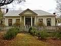 Chancellor House
- Chancellor House from rear
- Old Rock House
- Old Rock House from rear
Citations
- ↑ http://www2.census.gov/prod2/decennial/documents/37778831v2p2ch2.pdf
- ↑ http://www.shelbycountyreporter.com/articles/2007/10/26/lifestyles/life712.txt
- ↑ Circuit Court of Shelby County, Alabama 2012.
- ↑ Judicial Correction Services 2011.
- ↑ Rappleye & Seville 2014.
- ↑ Stillman 2014.
- ↑ Bronner 2012.
- ↑ Bronner 2012a.
- ↑ Huffington Post 2012.
- ↑ "US Gazetteer files: 2010, 2000, and 1990". United States Census Bureau. 2011-02-12. Retrieved 2011-04-23.
- ↑ "Annual Estimates of the Resident Population for Incorporated Places: April 1, 2010 to July 1, 2015". Retrieved July 2, 2016.
- ↑ "U.S. Decennial Census". Census.gov. Retrieved June 6, 2013.
- ↑ "Annual Estimates of the Resident Population: April 1, 2010 to July 1, 2013". Retrieved June 3, 2014.
- ↑ "American FactFinder". United States Census Bureau. Retrieved 2008-01-31.
- ↑ "American FactFinder". United States Census Bureau. Retrieved 2015-08-08.
- ↑ http://www.shelbycountyreporter.com/2004/10/05/first-black-mayor-takes-oath-of-office/
References
- Bronner, Ethan (2 July 2012), "Probation Fees Multiply as Companies Profit", New York Times, Childhildersburg, Alabama, retrieved 3 August 2014
- Bronner, Ethan (13 July 2012a), "Judge in Alabama Halts Private Probation", New York Times, retrieved 3 August 2014
- "Burdette vs Harpersville" (PDF), Circuit Court of Shelby County, Alabama, Civil Action No. CV 2010-900183, Shelby County, Alabama, 11 July 2012, retrieved 4 August 2014
- "Debtors Prison' Run by Harpersville Municipal Court Shut Down", Huffington Post, Columbiana, Alabama, 15 July 2012, retrieved 3 August 2014
- "INC Company Profile", Judicial Correction Services, 2010
- "Judicial Correction Services", Company website retrieved, 2011, retrieved 3 July 2012
- Rappleye, Hannah; Seville, Lisa Riordan (14 April 2014), "The Town That Turned Poverty Into a Prison Sentence", The Nation, retrieved 3 August 2014
- Stillman, Sarah (23 June 2014), "Get out of Jail, INC", The New Yorker, retrieved 3 August 2014
External links
Coordinates: 33°19′33″N 86°25′34″W / 33.325848°N 86.426121°W
Municipalities and communities of Shelby County, Alabama, United States | ||
|---|---|---|
| Cities |  | |
| Towns | ||
| CDPs | ||
| Unincorporated communities | ||
| Footnotes | ‡This populated place also has portions in an adjacent county or counties | |