Hardin, Missouri
| Hardin, Missouri | |
|---|---|
| City | |
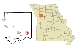 Location of Hardin, Missouri | |
| Coordinates: 39°16′10″N 93°50′0″W / 39.26944°N 93.83333°WCoordinates: 39°16′10″N 93°50′0″W / 39.26944°N 93.83333°W | |
| Country | United States |
| State | Missouri |
| County | Ray |
| Area[1] | |
| • Total | 0.64 sq mi (1.66 km2) |
| • Land | 0.64 sq mi (1.66 km2) |
| • Water | 0 sq mi (0 km2) |
| Elevation | 696 ft (212 m) |
| Population (2010)[2] | |
| • Total | 569 |
| • Estimate (2012[3]) | 555 |
| • Density | 889.1/sq mi (343.3/km2) |
| Time zone | Central (CST) (UTC-6) |
| • Summer (DST) | CDT (UTC-5) |
| ZIP code | 64035 |
| Area code(s) | 660 |
| FIPS code | 29-30322[4] |
| GNIS feature ID | 0730114[5] |
Hardin is a city in Ray County, Missouri, United States. The population was 569 at the 2010 census.[6]
History
Hardin was laid out in 1868.[7] It was named for Charles Henry Hardin, 22nd Governor of Missouri.[8]
Geography
Hardin is located at 39°16′15″N 93°50′4″W / 39.27083°N 93.83444°W (39.2708, -93.8344).[9]
According to the United States Census Bureau, the city has a total area of 0.64 square miles (1.66 km2), all of it land.[1]
Demographics
| Historical population | |||
|---|---|---|---|
| Census | Pop. | %± | |
| 1880 | 247 | — | |
| 1890 | 656 | 165.6% | |
| 1900 | 669 | 2.0% | |
| 1910 | 635 | −5.1% | |
| 1920 | 847 | 33.4% | |
| 1930 | 821 | −3.1% | |
| 1940 | 805 | −1.9% | |
| 1950 | 747 | −7.2% | |
| 1960 | 727 | −2.7% | |
| 1970 | 683 | −6.1% | |
| 1980 | 688 | 0.7% | |
| 1990 | 598 | −13.1% | |
| 2000 | 614 | 2.7% | |
| 2010 | 569 | −7.3% | |
| Est. 2015 | 542 | [10] | −4.7% |
2010 census
As of the census[2] of 2010, there were 569 people, 214 households, and 159 families residing in the city. The population density was 889.1 inhabitants per square mile (343.3/km2). There were 266 housing units at an average density of 415.6 per square mile (160.5/km2). The racial makeup of the city was 98.1% White, 1.1% Native American, 0.2% Asian, and 0.7% from two or more races. Hispanic or Latino of any race were 1.6% of the population.
There were 214 households of which 38.8% had children under the age of 18 living with them, 54.7% were married couples living together, 13.6% had a female householder with no husband present, 6.1% had a male householder with no wife present, and 25.7% were non-families. 21.5% of all households were made up of individuals and 8.8% had someone living alone who was 65 years of age or older. The average household size was 2.66 and the average family size was 3.04.
The median age in the city was 35.8 years. 28.3% of residents were under the age of 18; 8.5% were between the ages of 18 and 24; 25.5% were from 25 to 44; 27.3% were from 45 to 64; and 10.4% were 65 years of age or older. The gender makeup of the city was 49.0% male and 51.0% female.
2000 census
As of the census[4] of 2000, there were 614 people, 247 households, and 170 families residing in the city. The population density was 992.0 people per square mile (382.4/km²). There were 267 housing units at an average density of 431.4 per square mile (166.3/km²). The racial makeup of the city was 97.39% White, 0.16% African American, 1.14% Native American, 0.16% Asian, 0.33% from other races, and 0.81% from two or more races. Hispanic or Latino of any race were 0.33% of the population.
There were 247 households out of which 34.4% had children under the age of 18 living with them, 56.7% were married couples living together, 7.7% had a female householder with no husband present, and 30.8% were non-families. 27.5% of all households were made up of individuals and 17.8% had someone living alone who was 65 years of age or older. The average household size was 2.49 and the average family size was 3.04.
In the city the population was spread out with 28.5% under the age of 18, 8.6% from 18 to 24, 28.0% from 25 to 44, 19.7% from 45 to 64, and 15.1% who were 65 years of age or older. The median age was 36 years. For every 100 females there were 102.0 males. For every 100 females age 18 and over, there were 96.0 males.
The median income for a household in the city was $35,000, and the median income for a family was $40,729. Males had a median income of $30,809 versus $17,500 for females. The per capita income for the city was $14,676. About 7.9% of families and 6.1% of the population were below the poverty line, including 3.5% of those under age 18 and 11.3% of those age 65 or over.
Education
- Hardin-Central School District - preschool, elementary, and high school
References
- 1 2 "US Gazetteer files 2010". United States Census Bureau. Retrieved 2012-07-08.
- 1 2 "American FactFinder". United States Census Bureau. Retrieved 2012-07-08.
- ↑ "Population Estimates". United States Census Bureau. Retrieved 2013-05-30.
- 1 2 "American FactFinder". United States Census Bureau. Retrieved 2008-01-31.
- ↑ "US Board on Geographic Names". United States Geological Survey. 2007-10-25. Retrieved 2008-01-31.
- ↑ "Race, Hispanic or Latino, Age, and Housing Occupancy: 2010 Census Redistricting Data (Public Law 94-171) Summary File (QT-PL), Hardin city, Missouri". U.S. Census Bureau, American FactFinder 2. Retrieved September 6, 2011.
- ↑ Eaton, David Wolfe (1917). How Missouri Counties, Towns and Streams Were Named. The State Historical Society of Missouri. p. 345.
- ↑ Gannett, Henry (1905). The Origin of Certain Place Names in the United States. Govt. Print. Off. p. 149.
- ↑ "Halfway". Geographic Names Information System. United States Geological Survey. Retrieved 2009-05-03.
- ↑ "Annual Estimates of the Resident Population for Incorporated Places: April 1, 2010 to July 1, 2015". Retrieved July 2, 2016.
- ↑ "Census of Population and Housing". Census.gov. Retrieved June 4, 2015.
External links
- Hardin, Missouri is at coordinates 39°16′10″N 93°50′0″W / 39.26944°N 93.83333°W.
- City of Hardin website
- Historic maps of Hardin in the Sanborn Maps of Missouri Collection at the University of Missouri
Municipalities and communities of Ray County, Missouri, United States | ||
|---|---|---|
| Cities | 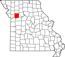 | |
| Villages | ||
| Townships | ||
| CDP | ||
| Other unincorporated communities | ||
| Footnotes | ‡This populated place also has portions in an adjacent county or counties | |