Hahn, Texas
| Hahn, Texas | |
|---|---|
| Unincorporated community | |
 Hahn, Texas Location within the state of Texas | |
| Coordinates: 29°16′53″N 96°23′49″W / 29.28139°N 96.39694°WCoordinates: 29°16′53″N 96°23′49″W / 29.28139°N 96.39694°W | |
| Country | United States |
| State | Texas |
| County | Wharton |
| Elevation | 128 ft (39 m) |
| Time zone | Central (CST) (UTC-6) |
| • Summer (DST) | CDT (UTC-5) |
| ZIP code | 77437 |
| Area code(s) | 979 |
| GNIS feature ID | 1379876[1] |
Hahn or Hahn Prairie is an Unincorporated community in northwest Wharton County, in the U.S. state of Texas. The tiny community is located at the intersection of Farm to Market Road 1160 (FM 1160) and Farm to Market Road 2546 (FM 2546) northwest of El Campo. There are no road signs identifying the site but the nearby Hahn Cemetery is marked and there is a small cluster of homes around the junction. The surrounding farmland is dotted by a number of natural gas wells.
Geography
The 1965 USGS Hahn Quadrangle map placed Hahn at the intersection of north-south FM 1160 and east-west FM 2546. In that year only a handful of buildings were recorded on the map near the town site.[2] Hahn is 12.2 miles (19.6 km) north of Louise and 6.3 miles (10.1 km) southwest of New Taiton on FM 1160. The Hahn crossroads is 4.2 miles (6.8 km) west of State Highway 71 and 3.3 miles (5.3 km) east of Mount Pilgrim Baptist Church on FM 2546. The Hahn Cemetery is 0.7 miles (1.1 km) east on FM 2546. Perhaps a dozen homes are bunched near the junction. West Mustang Creek flows south to the east of Hahn[3] while Porter's Creek flows south to the west of the community.[2] There are no road signs identifying the site but the nearby Hahn Cemetery is marked.[1] There are at least 15 gas leases and one oil lease in the vicinity of Hahn.[4]
History
The Handbook of Texas article writes of Hahn Prairie in the past tense. Hahn Prairie was located on the old Hahn Ranch 16 miles (25.7 km) northwest of Wharton in northwest Wharton County. A post office was established in the settlement in 1897. By 1905 the school reported two teachers and 32 students. Five years later 50 persons lived in Hahn. The post office closed in 1929. By 1933 only 20 souls lived in the community and there was only one store. The community center was abandoned in the 1940s. State highway maps identified Hahn Prairie as late as 1989. By that time only the school, cemetery and a few homes remained.[5]
-

FM 1160 crosses FM 2546 at the site of Hahn. The view is south.
-

Hahn Cemetery is on the south side of FM 2546 east of the crossroads.
-

One of only a few homes near the FM 1160 and FM 2546 crossroads. The view is northeast.
Notes
- 1 2 U.S. Geological Survey Geographic Names Information System: Hahn, Texas
- 1 2 "HAHN, TEX.". USGS. 1965. Retrieved June 22, 2013.
- ↑ Google (June 22, 2013). "Hahn, Texas" (Map). Google Maps. Google. Retrieved June 22, 2013.
- ↑ "Peter H. Hahn et al Gas Lease". Texas Drilling. Retrieved August 6, 2013.
- ↑ Kleiner, Diana J. "Handbook of Texas Online: HAHN PRAIRIE, TX". Texas State Historical Association. Retrieved June 22, 2013.
Municipalities and communities of Wharton County, Texas, United States | ||
|---|---|---|
| Cities | 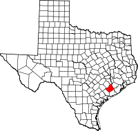 | |
| CDPs | ||
| Other unincorporated communities |
| |
| Ghost towns |
| |