Hackney (parish)

Hackney was a parish in the historic county of Middlesex. The parish church of St John-at-Hackney was built in 1789, replacing the nearby former 16th-century parish church dedicated to St Augustine (pulled down in 1798). The original tower of that church was retained to hold the bells until the new church could be strengthened; the bells were finally removed to the new St John's in 1854. See details of other, more modern, churches within the original parish boundaries below.
Ancient parish
The vestry of the parish, in common with all parishes in England, was entrusted with various administrative functions from the 17th century. The parish vestry administered the Poor Law until 1837, until it became part of the Poor Law Union of Hackney. The ecclesiastical and civil roles of the parish increasingly diverged, and by the early nineteenth century they covered different areas.
Civil parish

A distinct civil parish dates from 1855, with the incorporation of The Vestry of the Parish of Hackney in the County of Middlesex by section 42 of the Metropolis Management Act. With Stoke Newington it formed part of the Hackney District, governed by the Hackney District Board of Works, within the area of the Metropolitan Board of Works.
Under the Metropolis Management Act 1855 any parish that exceeded 2,000 ratepayers was to be divided into wards; as such the parish of St John at Hackney within the Hackney District Boards of Works was divided into seven wards (electing vestrymen): No. 1 or Stamford Hill (15), No. 2 or West (18), No. 3 or De Beauvoir Town (18), No. 4 or Dalston (18), No. 5 or Hackney (18), No. 6 or Homerton (15) and No. 7 or South (18).[1][2]
In 1894, the district and board were dissolved, with the Hackney vestry taking on its duties within the parish. In 1894 as its population had increased the incorporated vestry was re-divided into eight wards (electing vestrymen): Stamford Hill (15), West (18), Kingsland (12), Hackney (12), Mare Street (15), South (15), Clapton (12) and Homerton (21).[3][4]
In 1889 Hackney was included in the new County of London, and in 1900 the vestry was dissolved with the parish becoming the Metropolitan Borough of Hackney. The civil parish was abolished when the borough became part of the London Borough of Hackney in 1965.
The boundaries of the civil parish were identical to the ancient parish, and it covered 3,289 acres (13.3 km2). The populations recorded in National Censuses were:
Hackney St John's Vestry 1801–1899
| Year[5] | 1801 | 1811 | 1821 | 1831 | 1841 | 1851 | 1861 | 1871 | 1881 | 1891 | 1901 |
|---|---|---|---|---|---|---|---|---|---|---|---|
| Population | 12,730 | 16,771 | 22,494 | 31,047 | 37,771 | 53,589 | 76,687 | 115,110 | 163,681 | 198,606 | 219,272 |
Ecclesiastical parish

The ancient parish, was originally dedicated to St Augustine, but by c.1660 it had been rededicated to St John the Baptist and usually referred to as St John at Hackney.[6] It was in the Diocese of London. From 1825, as the population of Hackney increased, a number of new parishes were formed:[7]
- St John of Jerusalem, South Hackney in 1825
- St James, West Hackney aka (West Hackney Church) in 1825
- St Thomas the Apostle, Stamford Hill in 1828
- St Philip, Dalston in 1841
- St Peter, De Beauvoir Town in 1841
- St Barnabas, Homerton in 1846
- St James the Greater, Clapton in 1863
- St Augustine of Canterbury, Hackney Wick in 1867
- St Matthew, Upper Clapton in 1866
- Christ Church, Clapton in 1871
- All Saints, Lower Clapton in 1873
- St Luke, Homerton in 1873
- Holy Trinity, Dalston in 1879
- All Souls, Clapton Park in 1884
- St Michael and All Angels, Stoke Newington Common in 1886
- St Paul, Lower Homerton in 1889
- St Mary of Eton, Hackney Wick in 1893
- St Bartholomew, Dalston in 1897
In addition, as the population of neighbouring areas increased, parts of Hackney parish were included in new parishes:
- St Michael and All Angels, South Hackney London Fields in 1865 with parts of St Jude, Bethnal Green
- Christ Church, South Hackney in 1871 with parts of St James the Less, Bethnal Green, St John, Bethnal Green, and St Stephen, Haggerston
- St Mark, Dalston in 1871 with parts of St Matthias, Stoke Newington
External links
- Hackney Local Government
- Description of Hackney Parish in 1839
- Description of Hackney Parish in 1868
- Hackney Churches
Sources
- Guide to the Local Administrative Units of England, Vol.1, Frederic Youngs, London, 1979
- ↑ The London Gazette Issue: 21802. 20 October 1855. p. 3905-3907. Retrieved 9 April 2015.
- ↑ "H.M.S.O. Boundary Commission Report 1885 Hackney Map". Vision of Britain. Retrieved 9 April 2015.
- ↑ The London Gazette Issue: 26542. 14 August 1894. pp. 4713–4715. Retrieved 9 April 2015.
- ↑ The London Gazette Issue: 26563. 23 October 1894. p. 5937. Retrieved 9 April 2015.
- ↑ Statistical Abstract for London, 1901 (Vol. IV).
- ↑ , 'Hackney: The Parish Church', A History of the County of Middlesex: Volume 10: Hackney (1995), pp. 115-122. Date accessed: 13 March 2014.
- ↑ , 'Hackney: List of Churches', A History of the County of Middlesex: Volume 10: Hackney (1995), pp. 122-128. Date accessed: 13 March 2014.
| Districts |
| 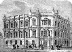 Headquarters at Spring Gardens |
|---|---|---|
| Incorporated vestries | Original vestries (1855)
Later vestries
| |
| Undertakings | ||
| Major works | ||
| Legislation | ||
| People | ||
History of the formation of the London Borough of Hackney | ||
|---|---|---|
| Metropolitan boroughs | 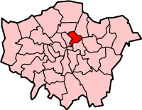 | |
| District boards | ||
| Parishes | ||
Coordinates: 51°32′51.98″N 00°03′17.08″W / 51.5477722°N 0.0547444°W