Granados, Baja Verapaz
| Granados | |
|---|---|
| Municipality of Guatemala | |
|
General Miguel García Granados, president of Guatemala from 1871 to 1873. Granados was named after him. | |
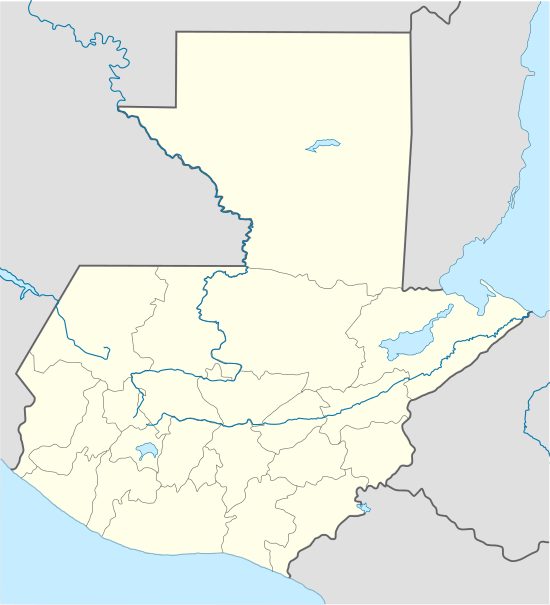 Granados Location in Guatemala | |
| Coordinates: 14°54′50″N 90°31′24″W / 14.91389°N 90.52333°W | |
| Country |
|
| Department |
|
| Government[1] | |
| • Mayor (2016-2020) | Byron Ronaldo Alvarado |
| Climate | Aw |

Granados is a municipality in the Baja Verapaz department of Guatemala. It was named Granandos in honor of former president Miguel García Granados in 1893.[2]
General information
Granados is located at the base of the Chuacus Mountains, in the river Motagua gorge, and is the farthest municipality from Baja Verapaz capital, Salamá It was named after former president general Miguel García Granados, leader of the Liberal Revolution in 1871, by a decree signed on 13 January 1893, by president general José María Reina Barrios.[2]
It has a surface of approximately 248 km2 and is famous in the region for its Rosa de Jamaica and Tamarindo beverages.
Population
Granados has a population of 10,096 according to the 1994 Census of the Statistics National Institute, with 10% being natives and the rest ladinos.
Main religious celebrations
Granados celebrated its main catholic celebration on 29 June, in honor of its former saint patron, Saint Peter from 1960 to 2000, but since the settlesment of the Granados' Black Christ, the latter became its official saint patron, and Granados started celebration on 15 January. However, starting in 2015 Granados decided to have two celebrations: one in June in honor of Saint Peter, saint patron of the town of Granandos and another on January, in honor of the Black Christ of Granados, saint patron of the municipality.[3]
Climate
Granados has a tropical savanna climate (Köppen: Aw).
| Climate data for Granados | |||||||||||||
|---|---|---|---|---|---|---|---|---|---|---|---|---|---|
| Month | Jan | Feb | Mar | Apr | May | Jun | Jul | Aug | Sep | Oct | Nov | Dec | Year |
| Average high °C (°F) | 27.7 (81.9) |
28.7 (83.7) |
30.1 (86.2) |
30.6 (87.1) |
29.9 (85.8) |
28.5 (83.3) |
28.4 (83.1) |
28.6 (83.5) |
28.0 (82.4) |
27.6 (81.7) |
27.6 (81.7) |
27.5 (81.5) |
28.6 (83.49) |
| Daily mean °C (°F) | 21.0 (69.8) |
21.8 (71.2) |
23.1 (73.6) |
24.1 (75.4) |
24.0 (75.2) |
23.5 (74.3) |
23.3 (73.9) |
23.2 (73.8) |
22.8 (73) |
22.3 (72.1) |
21.5 (70.7) |
20.8 (69.4) |
22.62 (72.7) |
| Average low °C (°F) | 14.3 (57.7) |
14.9 (58.8) |
16.2 (61.2) |
17.6 (63.7) |
18.1 (64.6) |
18.5 (65.3) |
18.2 (64.8) |
17.9 (64.2) |
17.7 (63.9) |
17.1 (62.8) |
15.5 (59.9) |
20.8 (69.4) |
17.23 (63.03) |
| Average precipitation mm (inches) | 1 (0.04) |
3 (0.12) |
6 (0.24) |
25 (0.98) |
91 (3.58) |
196 (7.72) |
125 (4.92) |
85 (3.35) |
158 (6.22) |
86 (3.39) |
15 (0.59) |
2 (0.08) |
793 (31.23) |
| Source: Climate-Data.org[4] | |||||||||||||
Geographic location
 |
Cubulco, Rabinal, Baja Verapaz Department municipalities[5] | | ||
| Pachalum and Joyabaj, El Quiché Department municipalities | |
El Chol, Baja Verapaz Department municipality | ||
| ||||
| | ||||
| San Juan Sacatepéquez Guatemala Department municipality San Martín Jilotepeque, Chimaltenango Department municipality |
See also
-
 Guatemala portal
 -
 Geography portal
 - Baja Verapaz
- Miguel García Granados
- List of places in Guatemala
Notes and references
References
- ↑ "Byron Tejeda gana elección a alcalde de Salamá". Prensa Libre (in Spanish). Guatemala. 8 September 2015. Retrieved 8 September 2015.
- 1 2 Escalante Herrera n.d.
- ↑ Monografías n.d.
- ↑ "Climate: Granados". Climate-Data.org. Retrieved 20 August 2015.
- ↑ SEGEPLAN n.d.
Bibliography
- Escalante Herrera, Marco Antonio (n.d.). "Municipios de Guatemala: Granados, Baja Verapaz" (in Spanish). Guatemala. Archived from the original on 17 April 2015. Retrieved 17 April 2015.
- Monografías (n.d.). "Granados". Monografías (in Spanish). Archived from the original on 22 November 2006. Retrieved 29 June 2015.
- SEGEPLAN (n.d.). "Municipios de Baja Verapaz, Guatemala". Secretaría de Planificación y Programación de la Presidencia (in Spanish). Guatemala. Archived from the original on 29 June 2015. Retrieved 29 June 2015.
| Capital | 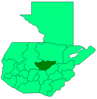 | |
|---|---|---|
| Municipalities | ||