Granada, Minnesota
| Granada, Minnesota | |
|---|---|
| City | |
 Location of Granada, Minnesota | |
| Coordinates: 43°41′43″N 94°20′54″W / 43.69528°N 94.34833°W | |
| Country | United States |
| State | Minnesota |
| County | Martin |
| Area[1] | |
| • Total | 0.59 sq mi (1.53 km2) |
| • Land | 0.59 sq mi (1.53 km2) |
| • Water | 0 sq mi (0 km2) |
| Elevation | 1,122 ft (342 m) |
| Population (2010)[2] | |
| • Total | 303 |
| • Estimate (2012[3]) | 299 |
| • Density | 513.6/sq mi (198.3/km2) |
| Time zone | Central (CST) (UTC-6) |
| • Summer (DST) | CDT (UTC-5) |
| ZIP code | 56039 |
| Area code(s) | 507 |
| FIPS code | 27-24884[4] |
| GNIS feature ID | 0644323[5] |
Granada is a city in Martin County, Minnesota, United States. Continuously populated since the late 19th century, after experiencing a boom during World War II, the population declined significantly - recorded at 303 as of the 2010 census.[6]
History
A post office called Granada has been in operation since 1891.[7] The city was named after Granada, in Spain.[8]
Geography
According to the United States Census Bureau, the city has a total area of 0.59 square miles (1.53 km2), all of it land.[1]
Demographics
| Historical population | |||
|---|---|---|---|
| Census | Pop. | %± | |
| 1900 | 309 | — | |
| 1910 | 333 | 7.8% | |
| 1920 | 387 | 16.2% | |
| 1930 | 397 | 2.6% | |
| 1940 | 431 | 8.6% | |
| 1950 | 403 | −6.5% | |
| 1960 | 418 | 3.7% | |
| 1970 | 381 | −8.9% | |
| 1980 | 377 | −1.0% | |
| 1990 | 374 | −0.8% | |
| 2000 | 317 | −15.2% | |
| 2010 | 303 | −4.4% | |
| Est. 2015 | 293 | [9] | −3.3% |
| U.S. Decennial Census | |||
2010 census
As of the census[2] of 2010, there were 303 people, 129 households, and 83 families residing in the city. The population density was 513.6 inhabitants per square mile (198.3/km2). There were 147 housing units at an average density of 249.2 per square mile (96.2/km2). The racial makeup of the city was 98.7% White, 0.3% African American, 0.7% from other races, and 0.3% from two or more races. Hispanic or Latino of any race were 0.7% of the population.
There were 129 households of which 28.7% had children under the age of 18 living with them, 45.7% were married couples living together, 12.4% had a female householder with no husband present, 6.2% had a male householder with no wife present, and 35.7% were non-families. 34.1% of all households were made up of individuals and 17.9% had someone living alone who was 65 years of age or older. The average household size was 2.35 and the average family size was 2.90.
The median age in the city was 41.6 years. 25.1% of residents were under the age of 18; 7.8% were between the ages of 18 and 24; 18.8% were from 25 to 44; 34.7% were from 45 to 64; and 13.5% were 65 years of age or older. The gender makeup of the city was 53.5% male and 46.5% female.
2000 census
As of the census[4] of 2000, there are 317 people, 131 households, and 75 families residing in the city. The population density is 539.9 people per square mile (207.4/km²). There are 136 housing units at an average density of 231.6 per square mile (89.0/km²). The racial makeup of the city is 99.68% White and 0.32% Native American. 0.32% of the population are Hispanic or Latino of any race.
There are 131 households out of which 32.8% have children under the age of 18 living with them, 52.7% are married couples living together, 4.6% have a female householder with no husband present, and 42.7% are non-families. 38.2% of all households are made up of individuals and 16.0% have someone living alone who is 65 years of age or older. The average household size is 2.42 and the average family size is 3.37.
In the city the population is spread out with 27.1% under the age of 18, 6.6% from 18 to 24, 29.0% from 25 to 44, 22.7% from 45 to 64, and 14.5% who are 65 years of age or older. The median age is 39 years. For every 100 females there are 104.5 males. For every 100 females age 18 and over, there are 90.9 males.
The median income for a household in the city is $31,042, and the median income for a family is $42,917. Males have a median income of $23,750 versus $22,500 for females. The per capita income for the city is $14,506. 6.8% of the population and 8.5% of families are below the poverty line. Out of the total population, 8.1% of those under the age of 18 and 5.0% of those 65 and older are living below the poverty line.
Education
Granada is part of the Granada-Huntley-East Chain School District. The school's boys' basketball team won the MSHSL Class A State Championship in 2009.
References
- 1 2 "US Gazetteer files 2010". United States Census Bureau. Retrieved 2012-11-13.
- 1 2 "American FactFinder". United States Census Bureau. Retrieved 2012-11-13.
- ↑ "Population Estimates". United States Census Bureau. Retrieved 2013-05-28.
- 1 2 "American FactFinder". United States Census Bureau. Retrieved 2008-01-31.
- ↑ "US Board on Geographic Names". United States Geological Survey. 2007-10-25. Retrieved 2008-01-31.
- ↑ "2010 Census Redistricting Data (Public Law 94-171) Summary File". American FactFinder. United States Census Bureau. Retrieved 27 April 2011.
- ↑ "Martin County". Jim Forte Postal History. Retrieved 21 July 2015.
- ↑ Upham, Warren (1920). Minnesota Geographic Names: Their Origin and Historic Significance. Minnesota Historical Society. p. 333.
- ↑ "Annual Estimates of the Resident Population for Incorporated Places: April 1, 2010 to July 1, 2015". Retrieved July 2, 2016.
Municipalities and communities of Martin County, Minnesota, United States | ||
|---|---|---|
| Cities | 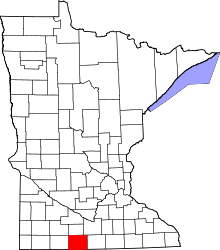 | |
| Townships | ||
| Unincorporated community | ||
| Footnotes | ‡This populated place also has portions in an adjacent county or counties | |
Coordinates: 43°41′44″N 94°20′52″W / 43.69556°N 94.34778°W